Scary Tropical/Subtropical North Atlantic Basin SSTA as The Most Active Part of TC Season Begins
08/06/2023, 11:12 am EDTU.S. JUN/JUL 2023 Verification Using Constructed Analog Forecasts
08/22/2023, 10:12 am EDTHeadline: Marine heat waves remain dominant, likely to influence 2023-24 El Nino. El Nino peak 2023 (falls just short of previous 3 most intense El Nino’s). Back to La Nina middle of next year.
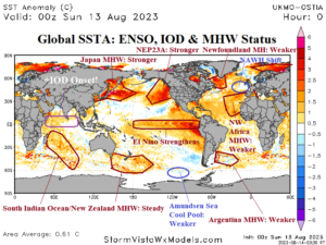
Fig. 1: Daily global SSTA analysis and identification of El Nino, IOD, and marine heat waves and 30-day trend.
Global SSTA observations/trend: As of August 12th, the global SSTA is +0.61C and has warmed slightly (+0.04C) during the past 30 days (Fig. 1). The North Atlantic basin is 1.02C warmer than normal with significant cooling during the past several weeks centered on the Newfoundland MHW while the anomalous warm tropics/subtropics are steady. El Nino has strengthened. Onset of the positive phase of the Indian Ocean dipole (+IOD) has arrived.
In the North Pacific, an immense MHW has strengthened across the northwest basin. Similarly, MHW NEP23A in the northeast Pacific has strengthened and shifted to the northwest coast of North America. In the North Atlantic basin, the North Atlantic warm hole (NAWH) recently shifted to coastal West Europe. However, the rapid development of a MHW off Newfoundland during late spring is now weakening quickly. The MHW off northwest Africa extending to the western Mediterranean Sea has weakened slightly.
In the southern hemisphere, typical of late winter, MHW’s are generally steady or weakened slightly including the South Indian Ocean and New Zealand MHW’s plus the Argentina MHW. The semi-permanent cool pool of SSTA across and northeast of the Amundsen Sea is weaker.
Large MHW’s cause the local atmosphere and areas that are downwind to warm creating stronger than normal high pressure which can accelerate drought risk when ridge areas extend over a land mass. Additionally, when high-pressure areas associated with MHW’s break down, incoming brief encounters with an upper trough cause unusually heavy rain as above normal low-level atmospheric water vapor associated with a warmer than normal ocean surface is entrained into the storm system often producing flooding rains. MHW’s are one catalyst to classic climate change era (weather and climate) regimes: Long-duration drought interrupted by brief heavy (flooding) rains.
El Nino 2023: Oceanic El Nino 2023 is coming on strong. Atmospheric El Nino intensity has lagged but has generated in August. To best identify the evolution of El Nino and project a trend, a review of the upper ocean heat regime from the past 4 months is helpful (Fig. 2). In April, ENSO was neutral although the subsurface was beginning to warm. The subsurface warmth broadened across the entire equatorial Pacific in May reaching the surface in the East Pacific. In June, the subsurface warmth was shifting eastward to begin earnest fueling of El Nino and El Nino 2023 onset was born. During July, subsurface warmth consolidated in the equatorial East Pacific to push ENSO into a stronger El Nino condition. The strengthening should continue.
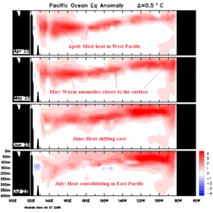
Fig. 2: The upper ocean heat to fuel El Nino has consolidated in the East Pacific which is an ideal location to propel El Nino intensity.
ENSO and PDO: El Nino 2023-24 is forecast to reach high intensity, possibly as strong as historic 1982-83, 1997-98, and 2015-16 episodes (Fig. 3). Contingent on strong intensity of El Nino 2023-24 is weakening and dissipation of the cool phase Pacific decadal oscillation (-PDO). Well documented in research is weaker El Nino climate anomalies when -PDO is present. The MHW in the Northeast Pacific has reached the coast (Fig. 4) and the 30-day trend implies the warmth will continue to spread south (Fig. 5) possibly joining forces with warming El Nino waters of the tropical/subtropical East Pacific. If so, an intense 2015-16-style El Nino will form. However, if global SSTA forecasts are correct (Fig. 6), and weak -PDO lingers, El Nino 2023-24 will reach moderate intensity only.
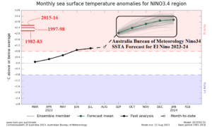
Fig. 3: The Australia Bureau of Meteorology Nino34 SSTA forecast indicates a potential prohibitive El Nino ahead, possibly stronger than previous intense El Nino episodes.
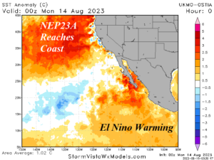
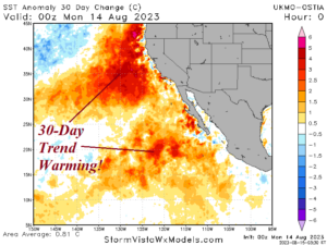
Fig. 4-5: Marine heat wave NEP23A has shifted east and reached the West Coast of the U.S., and the 30-day trend suggests farther southward warming which would erase the cool phase of the Pacific decadal oscillation and cause El Nino 2023 to strengthen.

Fig. 6: IMME global SSTA forecast valid December 2023 indicates an offshore Northeast Pacific MHW, lingering -PDO, and an over-forecast of El Nino intensity. If the MHW stays on the coast and expands southward, El Nino intensity indicated by IMME is more likely.
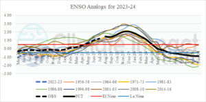
Fig. 7: ENSO analog years (since 1950) to project 2023-24 ENSO phase.
Analog forecast and ENSO 2024: Using all analogs (since 1950) where La Nina was followed by a moderate-to-strong El Nino yields peak of El Nino by December 2023 likely falling just short of the previous 3 most intense El Nino events (since 1950) and followed by a shift to weak La Nina by JUL/AUG 2024 (Fig. 7). The “best” analogs which were strongest with La Nina during initialization (similar in 2023) have a similar forecast (Fig. 8).
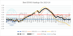
Fig. 8: The “best” analogs and their ENSO phase projection for 2023-24.
Summary: Oceanic El Nino began in June and atmospheric El Nino arrived in August. El Nino will continue to strengthen. Strong El Nino forecasts by several dynamic models, including the Australia Bureau of Meteorology, are dependent on the entire Northeast Pacific warming (ending cool phase Pacific decadal oscillation) and joining forces with ocean warming associated with El Nino in the tropical East Pacific. Observational trends support that regime although most global SSTA forecasts do not agree maintaining weak -PDO. Consequently, the intensity of El Nino 2023-24 remains uncertain. If -PDO continues with El Nino 2023-24, the El Nino climate influence is diminished. El Nino 2023-24 is likely to peak in December and followed by a reversal to La Nina by JUL/AUG 2024.