04/19/2025, 2:47 pm EDT

AI/Operational Models Spot Check Verification

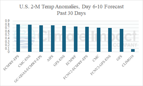
The 2-meter medium range temperature anomaly forecast skill across North America during the past 30 days reveals ECM ENS as the top model for both periods. The AI Graph Cast finished number 2 for the 6-10-day period while the improving CMC ENS reached number 2 in the 11-15-day period. Once again, GFS produced the lowest skill.
04/16/2025, 4:41 pm EDT

April 2025 Climate Impact Company Marine Heat Waves Outlook

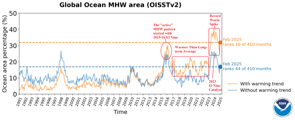
Climate Impact Company monitors marine heatwaves (MHW) due to their recent (past 10 years) increased presence and intensity and influence on climate patterns. Generally, anomalous high pressure extends across and downwind MHW regions, promoting drought risk while also adding low-level moisture to the atmosphere to cause over-achieving precipitation events and intensifying tropical cyclones.
04/15/2025, 5:18 am EDT

Recent Rapid Warming of Nino SSTA Regions Eases

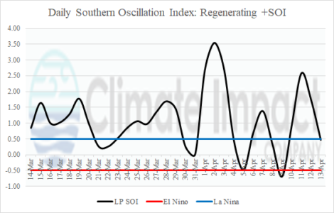
Weak or non-existent trade winds to up-well cool waters are starting to regenerate as the southern oscillation index (SOI) shifts to a mostly positive phase during the past 30 days.
04/15/2025, 4:56 am EDT

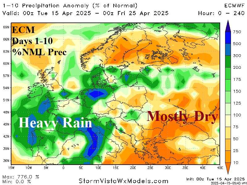
Heavy Rain Ahead Western Europe, Black Sea Turns Warmer

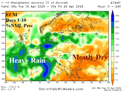
The recent cold wave across Southeast Europe to Turkey was caused by a polar vortex generation likely related to stratospheric warming in the polar region of the past 6 weeks. Another intense trough spins out of that regime and brings heavy rain to Southwest and South Europe through the next 10 days.
04/14/2025, 5:19 am EDT

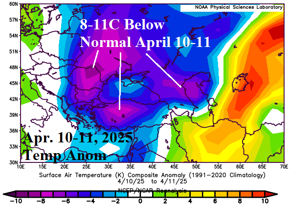
One of The Worst Freezes on Record Southeast Europe, Turkey, and into Black Sea Region

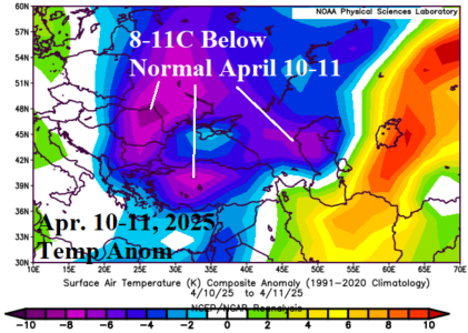
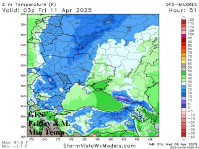
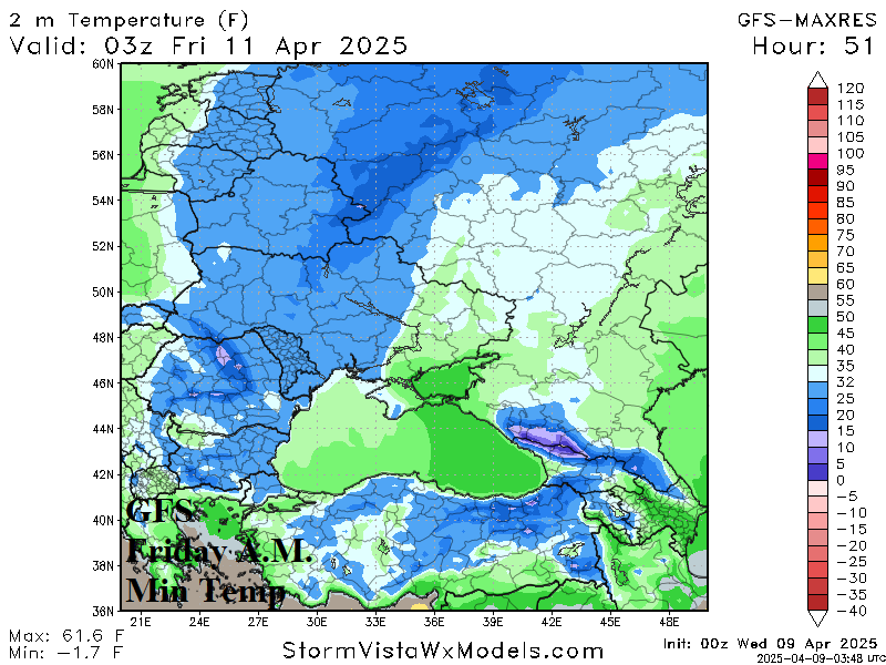
A late season cold wave has produced significant crop damage to the Eastern Europe/Black Sea/Turkey/Southwest Russia region. The farthest east cold spike was April 10-11 causing the worst freeze since 2014 in Turkey. The peak cold during April 7-9 was across Romania and Ukraine. Coldest mornings during the freeze events were in the -10’sC!
04/13/2025, 1:52 pm EDT

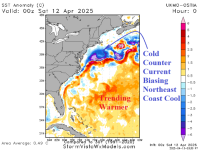
Influence of Cool (and Warm) SSTA on U.S. Climate

A cold north to northeast wind has brought rain and snow to New England this weekend thanks to an offshore storm system made colder by the frigid counter-current to the warm Gulf Stream east and southeast of New England.
04/11/2025, 8:53 am EDT

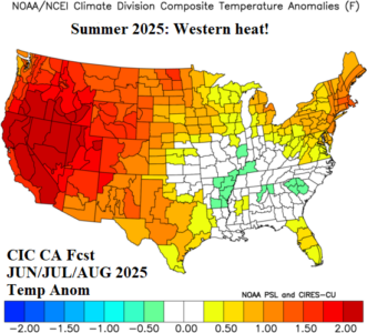
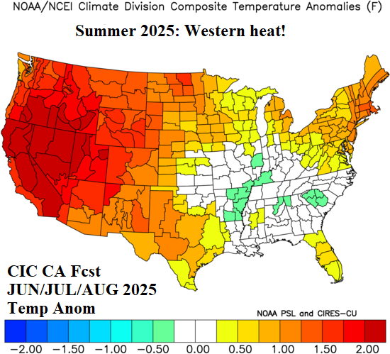
Forecast Confidence for U.S. Summer 2025 Outlooks

Comparing the CIC-CA summer 2025 outlook and the NOAA/CPC probabilistic summer 2025 outlook to establish confidence indicates a high probability of hot to very hot summer climate in the West, heavy rains in the Southeast, and a North-central to Interior Northwest U.S. drought.
04/10/2025, 7:49 pm EDT

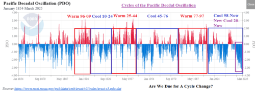
Are We Due for a Cycle Change of the Pacific Decadal Oscillation?

The cool cycle of the Pacific decadal oscillation has strengthened during recent years and will reach 30 years in duration if continued through 2026 as forecast by the Climate Impact Company constructed analog prediction. The 30-year duration matches the previous longest cool cycle observed during the middle 1940’s to middle 1970’s. Are we due for a long-term cycle change of the PDO?
04/10/2025, 4:10 am EDT

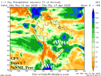
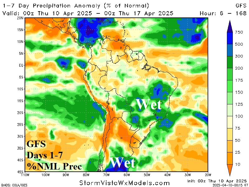
South America 2-Week Rainfall Forecast Trending Wetter!

While the U.S. AG Belt may receive some patchy wet weather during the medium range, the South America forecast is trending wetter. Rainfall increases in both Argentina and Brazil in the 2-week outlook, possibly too wet.
04/09/2025, 11:28 am EDT

Cold Weather into The Black Sea Region

Cold temperatures spread across Eastern Europe, Ukraine, and Southwest Russia this morning forecast to return Thursday morning concentrated on Eastern Ukraine. Another pulse of cold shifts into Romania and Western Ukraine Friday morning. The cold slowly retreats northward this weekend.
04/08/2025, 3:47 pm EDT

March 2025 Was Very Windy, 6th Warmest on Record

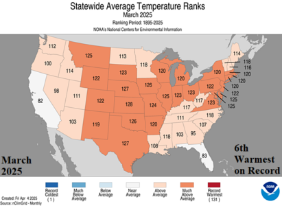
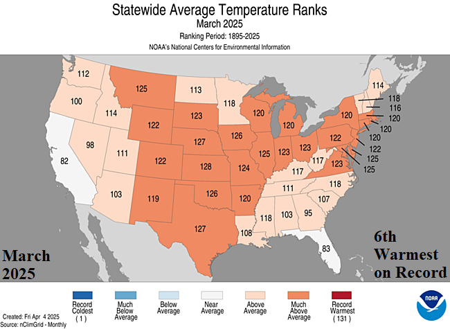
March 2025 was the 6th warmest in the 131-year climatology. MUCH ABOVE normal warmth was observed across much of the Central and Northeast U.S. including top 5 all-time for Kansas and Nebraska. Only Florida and California were near normal in the contiguous 48 states.
04/08/2025, 5:43 am EDT

Most Likely: Neutral ENSO 2025; El Nino 2026

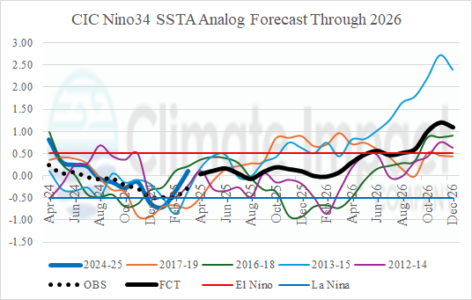
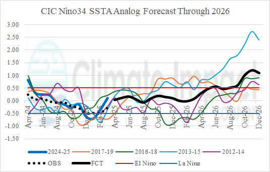
While the potential for El Nino development seems to be developing, the statistical and dynamic forecast models are only partially indicating weak El Nino potential and include a slight risk of weak La Nina returning later in 2025 while the consensus forecast is neutral ENSO through 2025. However, evidence to support El Nino return in 2026 is increasing.