09/10/2026, 5:37 am EDT

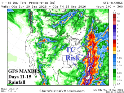
Tropical Trouble Brewing Days 11-15?

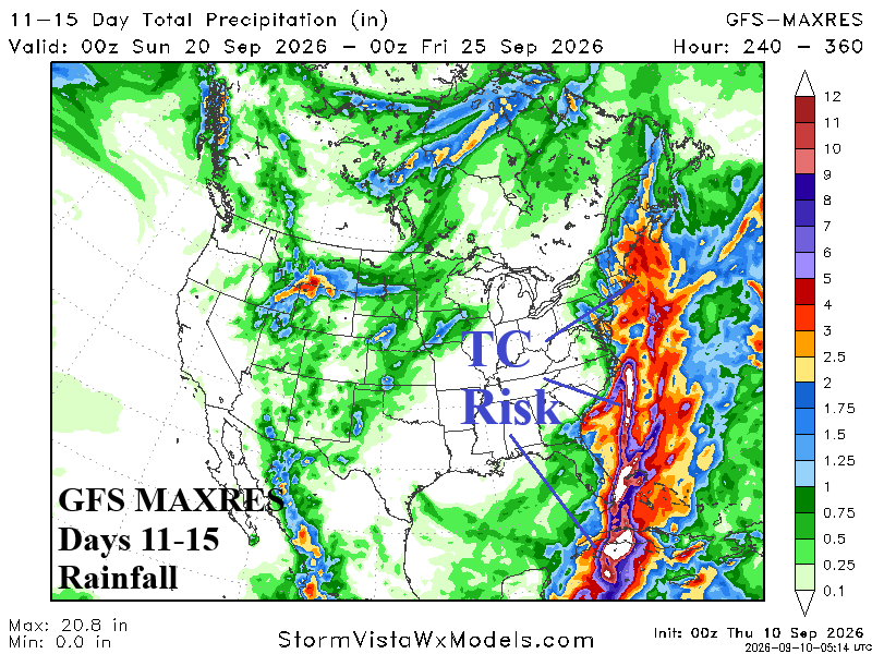
GFS and ECM are interested in generating heavy rain associated with a tropical cyclone during the 11-15-day period in the eastern Gulf of America and the Atlantic Seaboard. The consistency of this longer-range forecast is increasing. Reliability increases substantially if the threat appears in the 6-10-day forecast by early next week. However, for now, as calendar summer ends, an uptick in the dormant North Atlantic tropical cyclone season is expected.
09/09/2026, 4:21 pm EDT

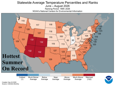
U.S. Daily Report: Summer 2026 is hottest on record.

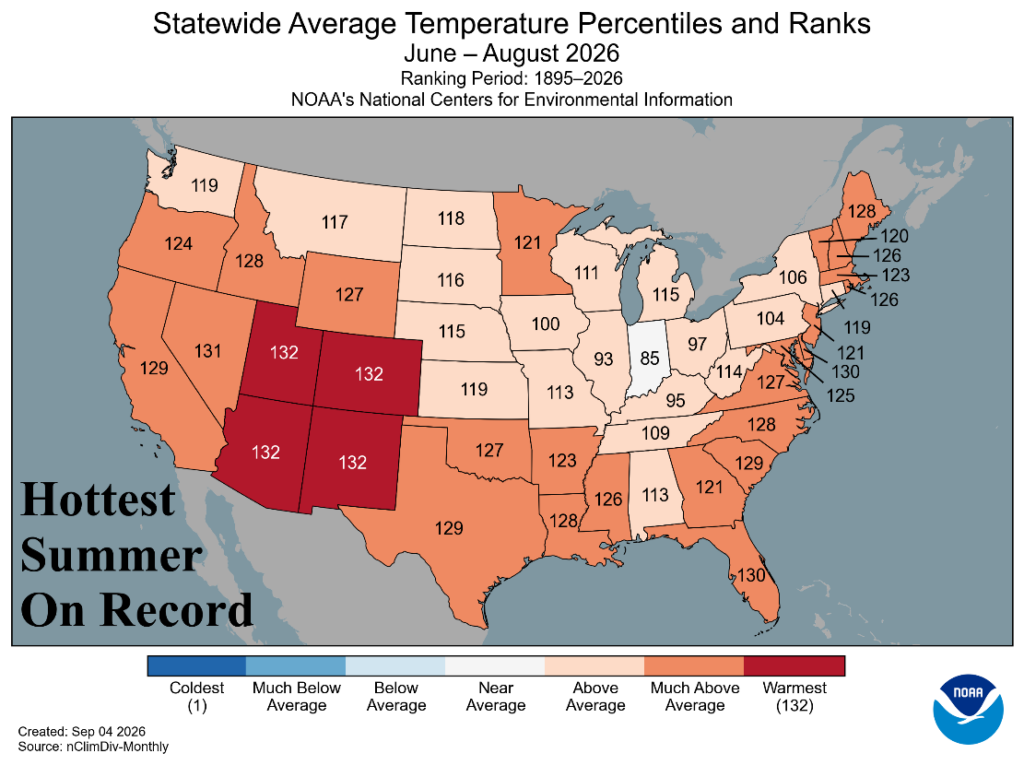
Summer 2026 was the hottest on record in the 1895-2026 U.S. climatology. Included were the hottest summer on record for Utah, Colorado, Arizona, and New Mexico. All 48 contiguous states were warmer than normal except Indiana. MUCH ABOVE normal to RECORD warm was observed in 27 states. The national rainfall ranking was in the driest third during the 132-year history. Regional differences were vast ranking from top ten driest on record in Oregon and California plus South Carolina while the entire Ohio Valley was MUCH WETTER than normal.
09/08/2026, 5:25 am EDT

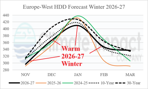
Warm U.S. AND Europe HDD Forecasts Winter 2026-27

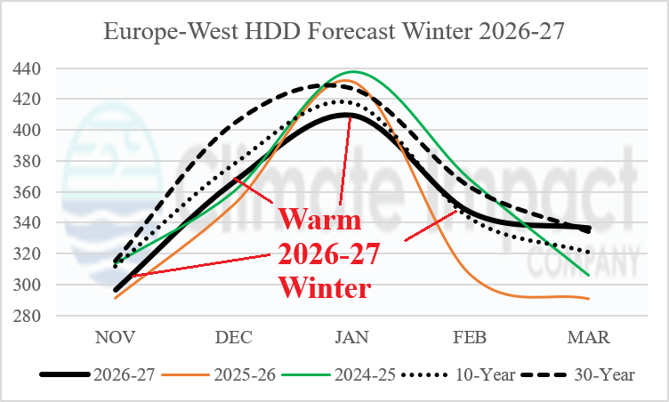
Western Europe observes warmer than normal winter season. A consensus of HDD forecasts for the NOV-MAR cold season reveals that Western Europe is warmer than the 10-year normal for November through January, near the 10-year normal in February, and near the 30-year normal in March.
09/08/2026, 5:14 am EDT

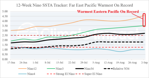
Eastern Equatorial Pacific is Now Record Warm!

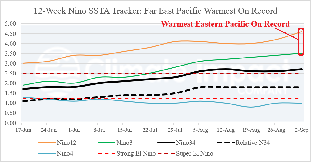
Last week, the Nino12 SSTA warmed to +4.6C and Nino3 SSTA surged to +3.5C combining for the warmest equatorial eastern Pacific Ocean surface temperature anomalies on record. In the Nino34 SSTA region, where ENSO phase is assessed, conventional Nino34 SSTA is +2.7C qualifying as Super El Nino while the new relative Nino34 SSTA index is +1.8C just below the Super El Nino threshold.
09/07/2026, 4:33 pm EDT

Looking Wetter Great Plains Ahead

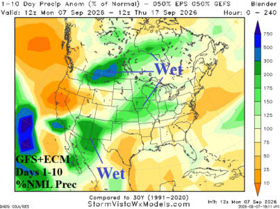
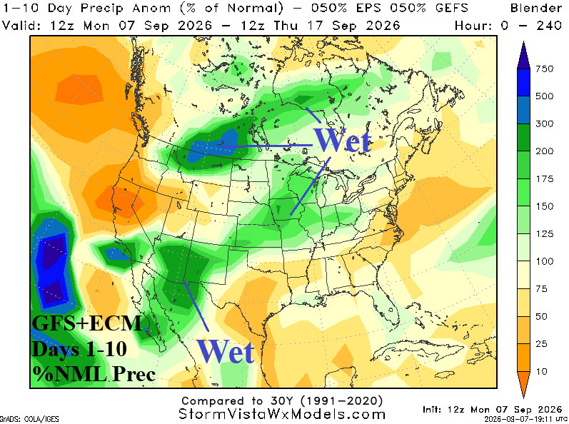
GFS and ECM combined are reasonably similar during the next 10 days. Indicated is a northeastward tilt of wet monsoon weather in the Southwest States toward and across the Great Plains.
09/07/2026, 1:29 pm EDT

East Pacific Tropical Cyclones Affecting North America Upper Air Pattern

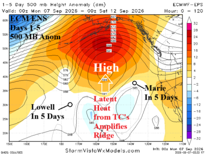
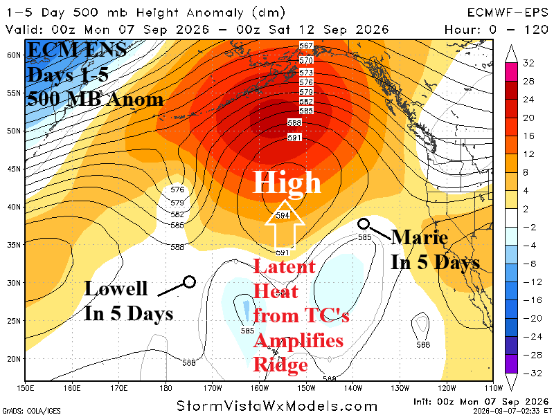
Hurricane Lowell moves north, to just west of Kauai tonight, and weakens slowly to a tropical storm while turning westward later this week while Tropical Storm Marie drifts northwestward staying well west of California. Additional tropical systems are possible in the East Pacific this week. The latent heat release from the attendant convection of each system causes the high-pressure system to the north to amplify this week and shift slightly eastward in the 6-10-day-period maintaining strength as additional latent heat from tropical/subtropical convection to the south continues.
09/04/2026, 5:28 am EDT

PJM-East Heat Spikes Lingering Into September

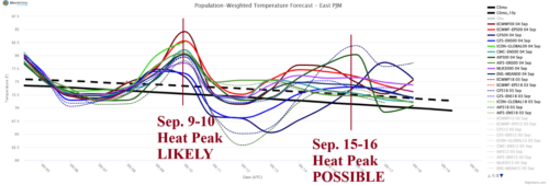
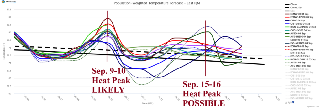
PJM-East (in fact all of PJM) was hit hard, again, by heatwave conditions this week. The amplified heat stress is the 5th event of the summer season in PJM-East. Uncommon (and un-welcomed) peak heat events in September are likely to continue although with less amplitude.
09/04/2026, 4:49 am EDT

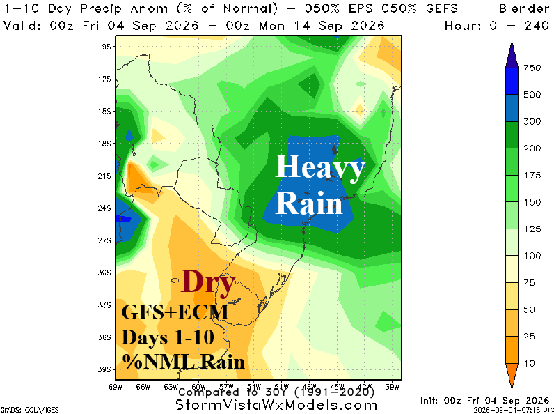
East/Southeast Brazil Forecasts Trend Wetter

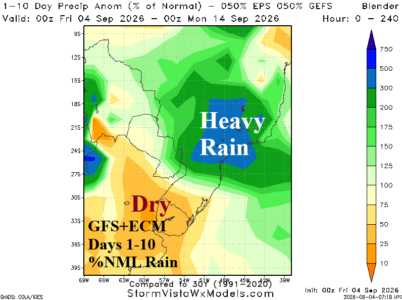
ECMWF is most aggressive with the ongoing rains in Southeast/East Brazil. The outlook is supported by ongoing negative Antarctic oscillation (-AAO) which implies semi-permanent low-pressure troughs in the middle latitudes. ECMWF projects a semi-permanent low-pressure trough east of Argentina located across an area of relative cool SSTA. Meanwhile, east of Brazil, a marine heat wave (MHW) is expected to strengthen. The upper trough entrains increased low-level atmosphere moisture across the MHW driving a wetter Southeast/East Brazil climate likely to last through spring.
09/03/2026, 8:49 am EDT

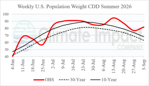
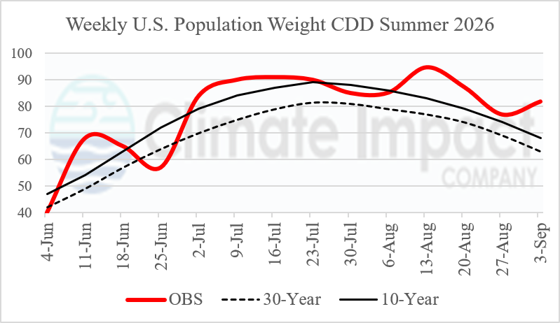
Latest U.S. CDD Forecast Maintain Late Calendar Summer Heat

The late calendar summer U.S. population weight CDD forecast emphasizes excessive cooling demand. Weekly summer 2026 U.S. population weight CDD indicate the majority of weeks were warmer than the 10-year climatology.
09/03/2026, 5:50 am EDT

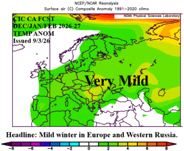
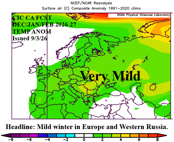
Mild Winter 2026-27 Europe/Western Russia Outlook

The Climate Impact Company winter 2026-27 outlook for Europe and Western Russia is milder than normal with record warmth possible in December. The warm SSTA regimes surrounding Europe, across much of the North Atlantic basin, and combined with Super El Nino are the catalyst to the mild outlook.
09/01/2026, 11:15 am EDT

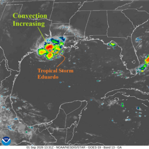
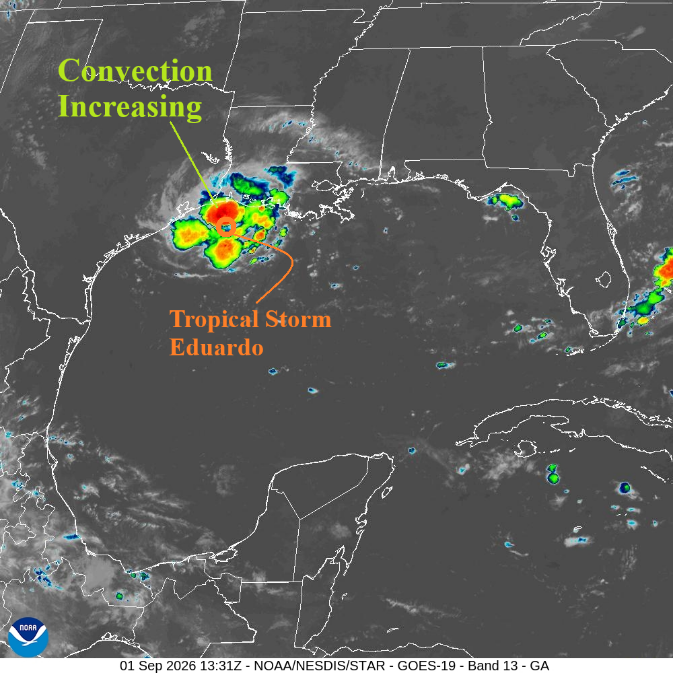
Sneaky Intense Eduardo

Eduardo is shifting over 31C surface water in a light shear environment. Rapid intensification is possible, given the light shear environment. NOAA/NHC issues a Hurricane Watch and Storm Surge Warning for the Upper Texas and Southwest Louisiana Coast.