Incoming Arctic Air Causes Widespread Major Ice Storm South/Southeast U.S. This Weekend
01/20/2026, 5:14 am EST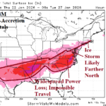
Significant Ice Accretion Forecast Edging Northward for Weekend Storm Especially Mid-Atlantic
01/22/2026, 9:56 am EST
Climate Impact Company Early U.S. Notes
Issued: Wednesday January 21, 2026
Highlight: Forecast confidence and hazards increasing. Texas cold is stronger, major Interior South U.S. ice storm, heavy snows Virginia/Northeast Coast.
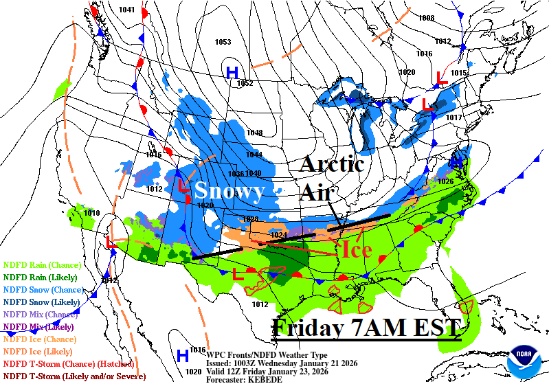
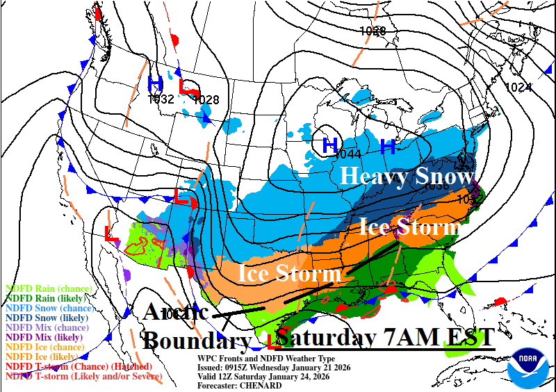
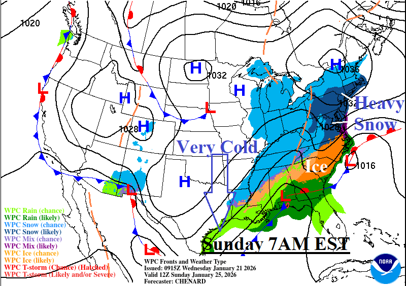
Fig. 1-3: NOAA/WPC frontal positions for incoming arctic air Friday through Sunday morning at 7AM EST.
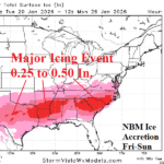
Discussion: Arctic air plows through the Great Plains quickly Thursday night reaching the southern Great Plains by dawn Friday (Fig. 1). At that time, a strip of freezing rain and icing develops along the arctic air boundary. The icing area gradually expands Friday/Friday night stretching from central/northern Texas to The Carolinas by Saturday morning (Fig. 2). Significant accreting ice is occurring causing power outages and major travel difficulties. The snow area expands rapidly eastward and by Friday night heavy snow is blanketing the Tennessee Valley eastward to the Mid-Atlantic States. Snowfall occurs with enough wind to cause blowing and drifting which makes travel difficult. By Saturday morning, the arctic boundary is just northwest of Houston. On Saturday, the icing continues while edging southward into the Houston area and maintaining intensity from Arkansas to the Carolinas. Ice accretion in the 0.5 to 1.0 in. range is possible which will cause widespread power outages. Heavy snow continues Sunday morning (Fig. 3) in the Mid-Atlantic region stretching north to southern New England. Very cold temperatures reach the northwest Gulf Sunday morning as the storm shifts eastward. Snow lingers on the Northeast Coast Monday. NBM forecasts storm snowfall total at 18-21 inches across Virginia to New Jersey with 10-15 inches possible southeast Massachusetts (Fig. 4). A foot or more of snow is expected across a large part of the eastern Tennessee Valley. Arkansas to Oklahoma receives close to a foot of snow. Of course, the deep snow cover allows incoming cold to reach the Gulf Coast (more) effectively, particularly the northwest Gulf Coast. The greatest hazard is ice accretion which is forecast to reach 0.25 to 0.50 inches from central Texas to the Carolinas with high spots possibly exceeding 1.0 inches (Fig. 5). The threshold for most to total loss of power is usually around 0.5 inches of ice. Arctic cold intensity increases especially once the accreting ice ends. The U.S. gas population weight HDD forecast indicates the coldest last week of January this century and is followed by a colder revision for early February. Of note, the extremely negative arctic oscillation (-AO) driving the cold weather historically lingers in February.
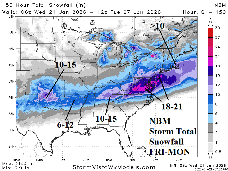
Fig. 4: NBM storm total amount of snowfall forecast.
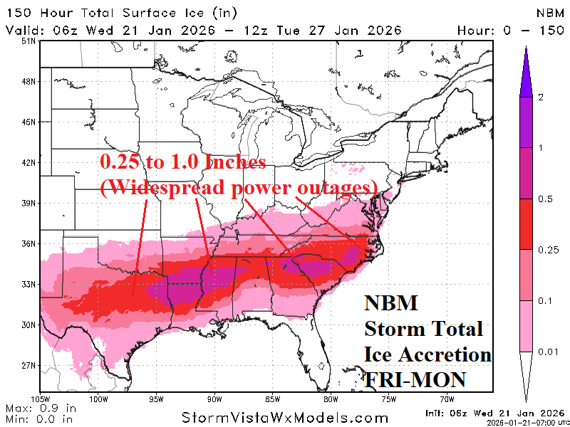
Fig. 5: NBM storm total of ice accretion forecast.

Fig. 6: U.S. gas population weight forecast utilizing all models through early February.