Weak La Nina Continues
11/25/2025, 5:42 am EST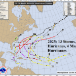
North Atlantic 2025 Tropical Cyclone Season Review, Preliminary 2026 Forecast
12/01/2025, 4:38 pm EST
Climate Impact Company Month 1-4 (Summer 2025-26) Outlook
Australia
Issued: Friday, November 28, 2025
Highlight: Unexpected drier change for Eastern Australia during summer 2025-26.
Executive Summary: The latest Climate Impact Company constructed analog climate forecast for meteorological summer 2025-26 has changed. The outlook is drier across East Australia and hotter across Southeast/South-central Australia. The anomalous heat and dryness in this region indicate expanding drought is likely. The wet zones touch Coastal Queensland and much of northwestern continent. The dry regime in the East is surprising given presence of organizing La Nina. However, La Nina dissipates quickly by late summer. The negative Indian Ocean dipole regime, normally a wet influence on Australia climate, is weakening.
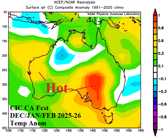
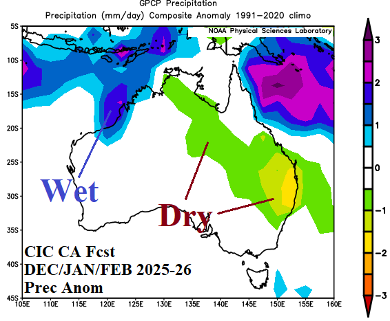
Fig. 1-2: The DEC/JAN/FEB 2025-26 Climate Impact Company temperature and precipitation anomaly climate forecast.
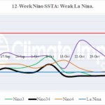
Climate discussion: Wet weather returned to parts of the East Coast during November after an exceptionally dry October (Fig. 3-4). However, coastal New South Wales plus inland areas remained dry. Consequently, NOAA/CPC identifies dry-to-drought conditions in New South Wales and parts of Victoria expanding northeastward (Fig. 5). The NOAA/CPC soil moisture anomaly analysis reveals dry conditions across Western Australia although Australia Bureau of Meteorology does not indicate the dryness. The SSTA regime attached to the prevailing climate across Australia includes a weak but well-defined La Nina (Fig. 6). During recent weeks, the southern oscillation (SOI) is mostly strongly positive indicating La Nina climate has become established. Usually, La Nina brings wetter than normal climate to northern and eastern Australia. The Indian Ocean dipole (IOD), previously in strong negative phase, has weakened considerably. Usually, -IOD propels a wetter than normal climate across western and eastern Australia. Interestingly, neither La Nina or -IOD has produced a consistently wet climate across Australia during mid-to-late spring. A potential reason for the lack of expected rainfall is lingering cold season effects of the polar vortex. The Antarctic oscillation (AAO) also referred to as southern annular mode (SAM) has inspired deep mid-latitude troughs preventing full-throttle influences of the (La Nina/-IOD) tropical regime. The ECMWF JAN/FEB/MAR 2026 global SSTA forecast indicates La Nina weakens to neutral phase and -IOD also ends with a possible trend toward +IOD (Fig. 7). Marine heat waves (MHW) produce significant influence of Australia climate. Strong MHW’s east of Australia now expand southwestward while another MHW southwest of the continent expands and strengthens.

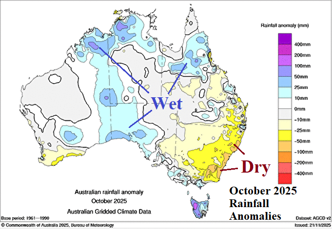
Fig. 3-4: The NOV-25 (so far) rainfall anomalies across Australia compared to the OCT-25 analysis.
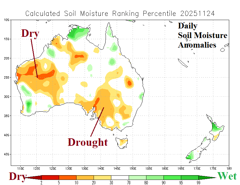

Fig. 5-6: The Australia daily soil moisture anomalies analysis and recent weekly global sea surface temperature anomalies observations.
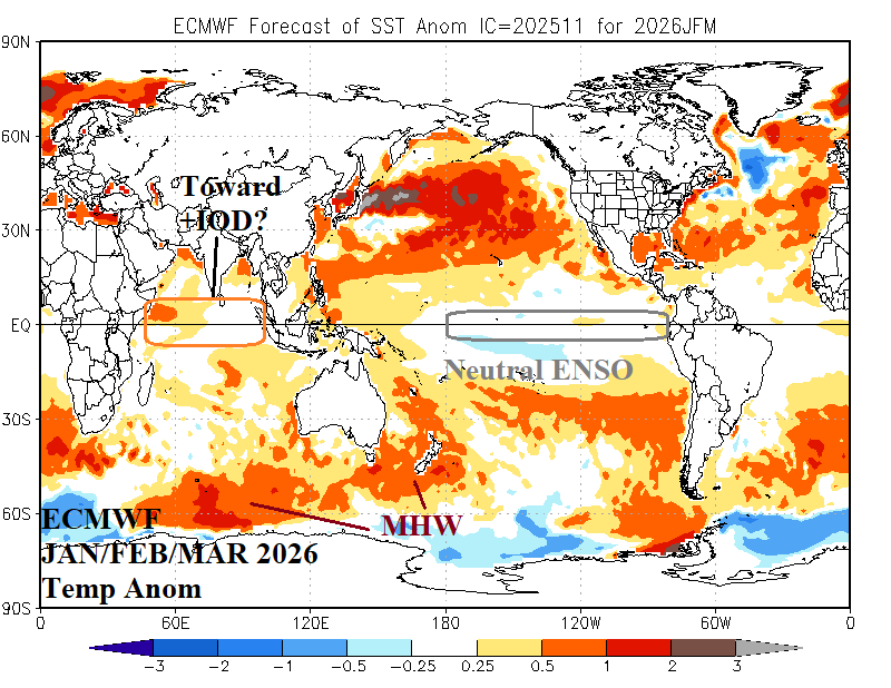
Fig. 7: The ECMWF global SSTA forecast for JAN/FEB/MAR 2026 and regions of influence on Australia climate.
December 2025: The Climate Impact Company constructed analog (CIC-CA) forecast for DEC-25 yields a hotter than normal continental regime with a major forecast change across North and East Australia toward a drier than normal climate. The MHW east of Australia is correlated to stronger subtropical high pressure ridging westward into Eastern Australia to cause the dryness and anomalous heat despite the presence of La Nina which usually causes wet weather in this sector. The drier CIC-CA forecast for Eastern Australia is not agreeable to NCEP CFS V2 or ECMWF (both) favoring wetter than normal climate for Eastern Australia. Operational forecasts through 15 days and well into December indicate a mix of dry and patchy wet weather conditions beneath an upper trough in the East while the ridge pattern is well offshore.
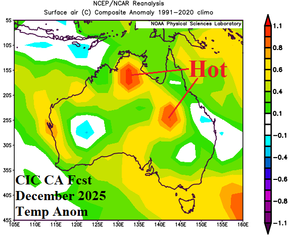
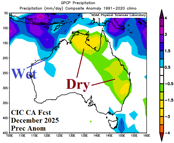
Fig. 8-9: The Climate Impact Company constructed analog temperature and precipitation anomaly forecast for December 2025.
January 2026: The JAN-26 outlook trend is hotter across eastern South Australia, western Victoria, and southwestern New South Wales as drought strengthens in this region. Coastal New South Wales is normally wet and cooler than normal. The drier than normal climate in the East extends from the Queensland/New South Wales border westward across southern and western Queensland. The northwestern coast is wetter than normal while wet anomalies touch Coastal Queensland and the North Coast of Australia.
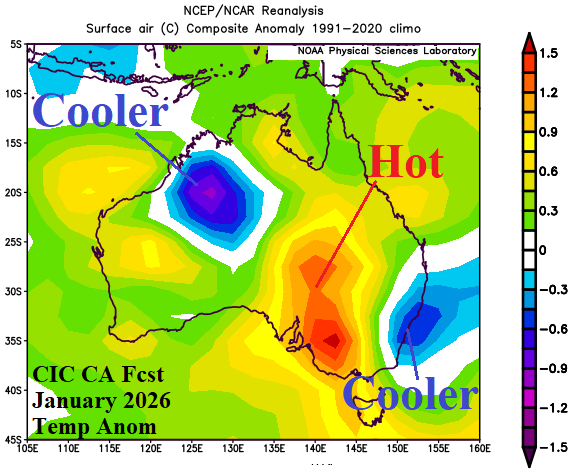
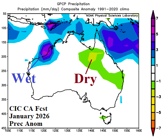
Fig. 10-11: The Climate Impact Company constructed analog temperature and precipitation anomaly forecast for January 2026.
February 2026: Late meteorological summer is dry and hot across much of the southern half of Australia while wet weather risk suppressing late summer heat is forecast for Northern Queensland and westward. The forecast is revised drier in the East and hotter across the South possibly due to rapid dissipation of La Nina and influence on the upper air pattern of strong MHW’s east and southwest of Australia.
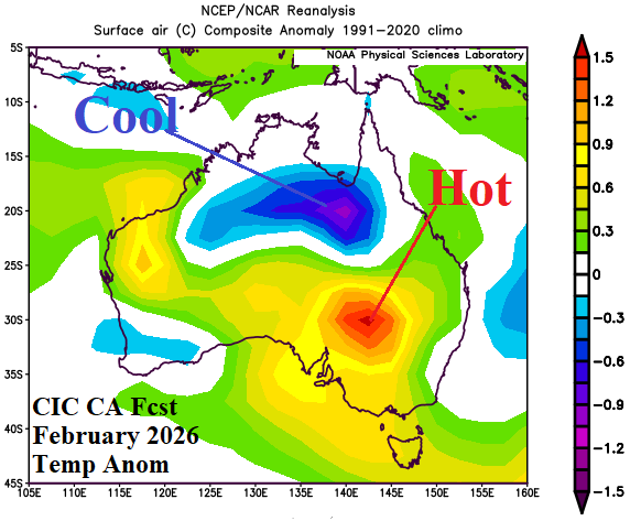
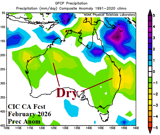
Fig. 12-13: The Climate Impact Company constructed analog temperature and precipitation anomaly forecast for February 2026.
March 2026: Of the 4 months in the updated Australia monthly climate forecast, MAR26 remains remarkably consistent with wet weather in the East and dry climate across the West. Much of the continent is hotter than normal with the exception of North-central Australia where wet weather suppresses anomalous heat risk.

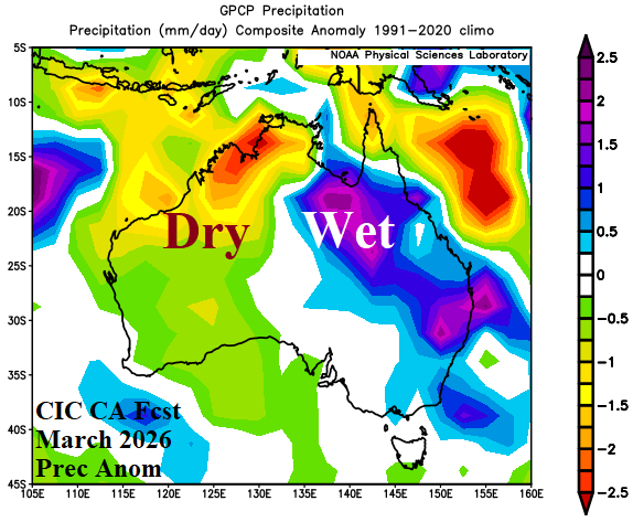
Fig. 14-15: The Climate Impact Company constructed analog temperature and precipitation anomaly forecast for March 2026.