06/23/2026, 1:06 pm EDT

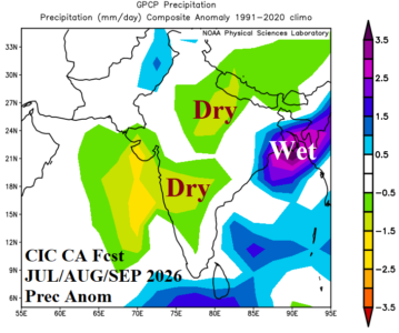
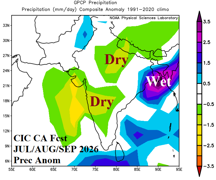
India To Observe Partially Failed Wet Monsoon Next 3 Months; Drought Central India

The Climate Impact Company month 1-4 precipitation outlook for India is updated. The forecast is driven primarily by warm ENSO analog years and partially by marginally positive phase Indian Ocean dipole (+IOD). The outlook does not completely fail the wet monsoon due to impacts of El Nino. However, key crop areas in Central India are likely to encounter developing and strengthening drought during the next several months.
06/23/2026, 9:25 am EDT

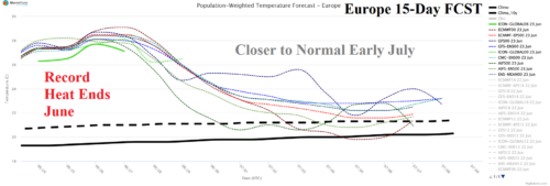
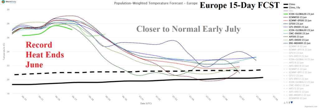
Extreme Heat in Europe Eases by Early July

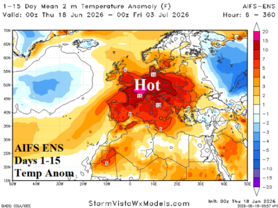
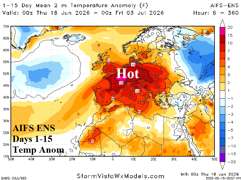
The record heat across Europe, centered on France, roars on this week likely to last through June before a pattern change that shifts temperatures toward normal. The less hot pattern change is driven by a shift in the North Atlantic oscillation (NAO) from positive to negative phase.
06/23/2026, 9:21 am EDT

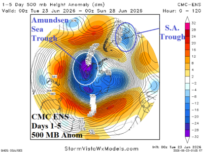
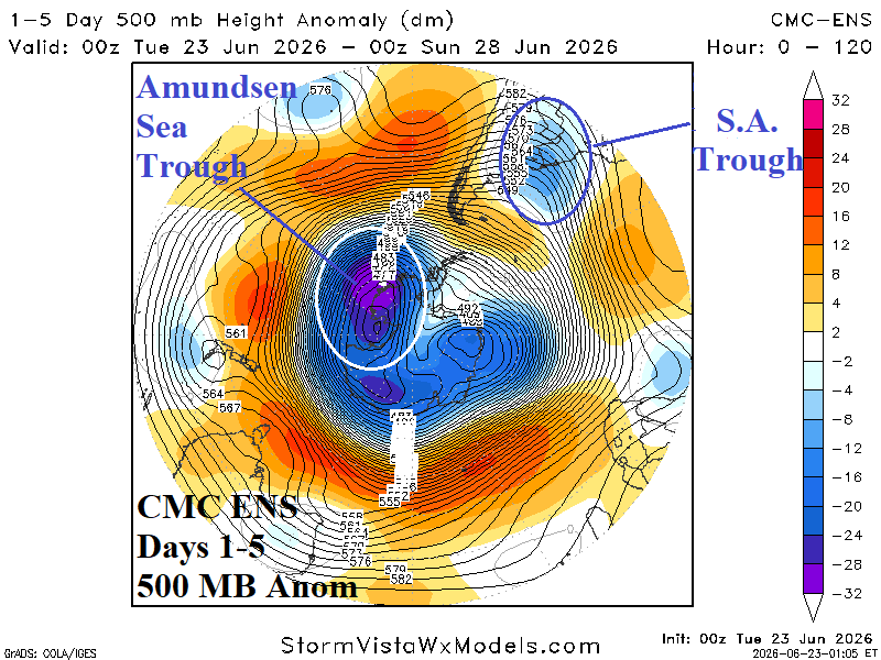
Deep Polar Vortex Over Amundsen Sea and Downstream Trough Eastern South America

Earlier this month, record warm temperatures dominated parts of Antarctic located due south of the southern tip of Argentina. Esperanza Base located on the northern tip of the Trinity Peninsula observed a winter record 15.4C on June 6th. Other research stations observed similar record warmth and for nearly 3 straight weeks, daily maximum temperatures in this region stayed above 32F causing extreme melting leaving the mountain bases of the Collins Glacier with bare ground. However, the real meteorological story across Antarctica is not the record warmth due south of Argentina, but the ferocious cold resting on the remainder of the continent.
06/21/2026, 3:37 pm EDT

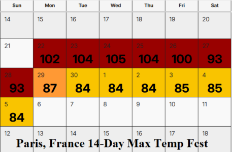
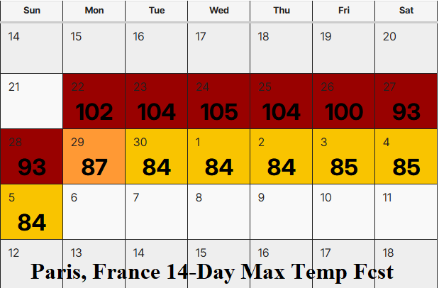
Searing Heat for Europe Next 7-10 Days

Searing heat remains in the forecast for Europe during the last 10 days of June. The hot weather episode is hotter than 2 recent events (6/18 and 5/26). Paris, France is above 100F all week. The 15-day forecasts are very dry and hot accelerating drought concerns. Climate signals indicate the heat should ease in the 11-15-day period.
06/21/2026, 1:31 pm EDT

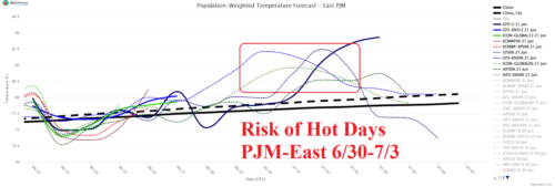
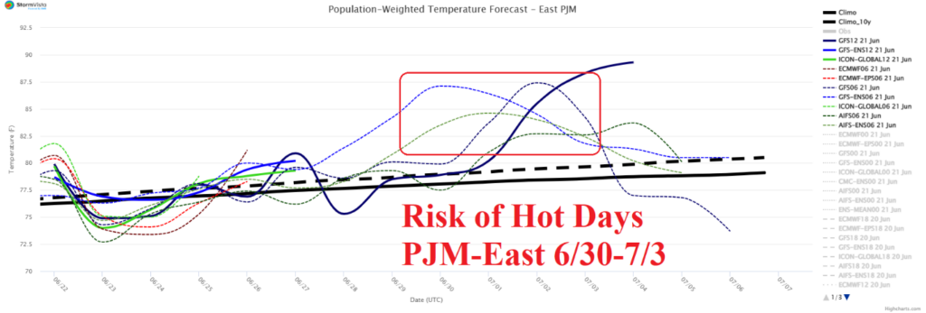
June 30-July 3 PJM-East Heatwave

A lot of market interest on PJM-East heat risk for late June. The latest 15-day forecast reveals most models indicate heatwave potential. ALL MODELS project 93-95 for Washington, DC. GFS ENS is hottest at 98.
06/21/2026, 1:27 pm EDT

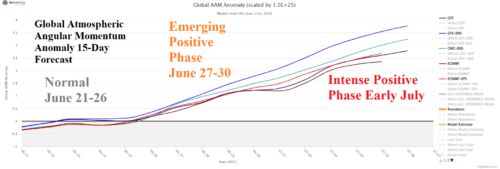
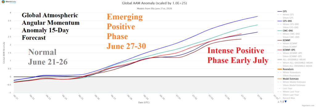
El Nino Climate Ahead! Intense +GLAAM Supports!

Emergence of the strong El Nino climate is seen in the evolution of strong positive phase global atmospheric angular momentum (+GLAAM) by late JUN/early JUL. +GLAAM is characteristic of a strong El Nino climate as westerlies aloft in the middle latitudes increase due to the interaction between increasing El Nino convection in the deep tropics and the dynamic forcing on mid-latitude upper airflow. The global wind oscillation (GWO) forecast indicates most of the forcing is in the eastern hemisphere (phase_5, phase_6, and phase_7).
06/18/2026, 9:48 am EDT

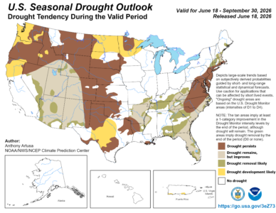
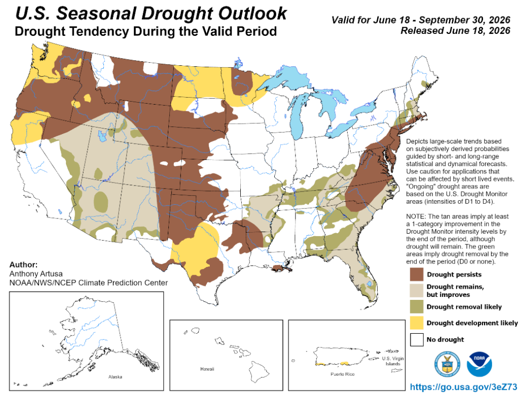
New NOAA Long-lead Climate Forecasts Including Seasonal Drought Outlook

The NOAA/CPC Seasonal Drought Outlook based on the 90-day long-lead climate forecast indicates the Southwest U.S. Drought eases while drought over the Northwest and Western Great Plains expands adding the Coastal Northwest, Upper Midwest, and Interior Texas. Mid-Atlantic States maintain their drought while New England and Florida drought conditions will erode.
06/18/2026, 8:31 am EDT

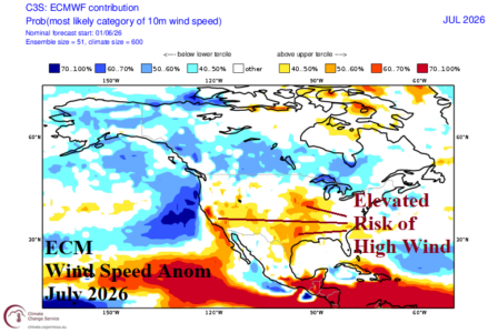
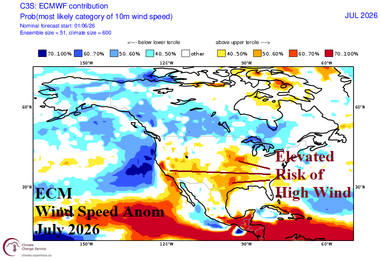
ECMWF Is Windy California and Texas to Midwest U.S. in July 2026

ECMWF is aggressive forecasting above normal windspeeds in Texas to the Midwest States during mid-summer. Additionally, stronger than normal wind speeds are projected in California to the Great Basin region. Below normal windspeeds are projected across much of Canada.
06/18/2026, 6:05 am EDT

Aggressive Hot and Dry Forecasts for Europe

Forecast models continue to make the case for developing and intensifying drought across much of Europe given continued hot and mostly dry 15-day forecasts and 16-30-day projections.
06/17/2026, 8:41 am EDT

Tropical Depression One is a Trouble-maker

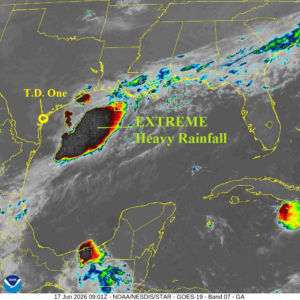
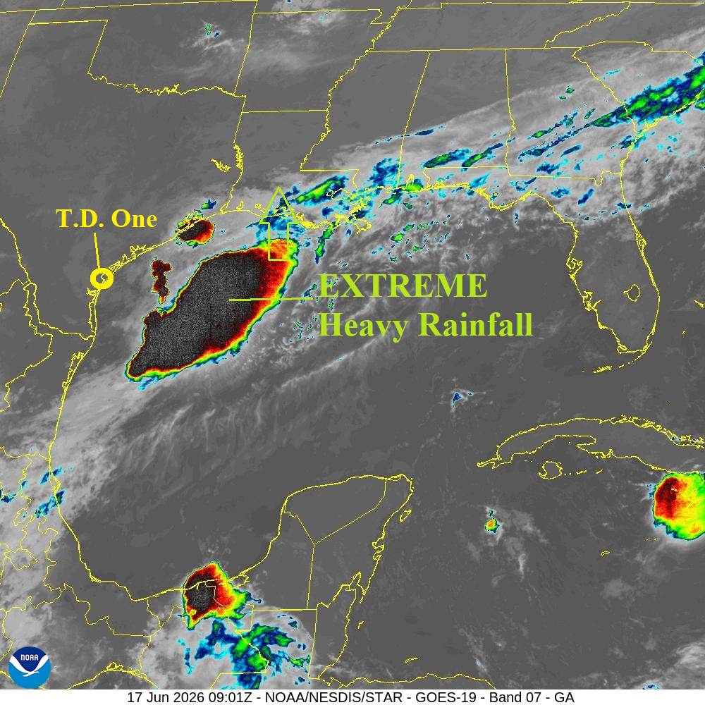
NOAA/NHC indicates a brief upgrade to a tropical storm (Arthur) before moving inland this evening. Tropical cyclone models generally doubt tropical storm intensity. A large area of extreme rain is located east of the depression shifting north and northeast to bring heavy rains to the Gulf States/Southeast U.S. the next 2-3 days.
06/17/2026, 4:17 am EDT

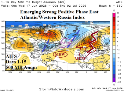
Positive Phase East Atlantic/West Russia Index into Mid-summer Causes Midwest/Northeast U.S. Rain/Europe Drought

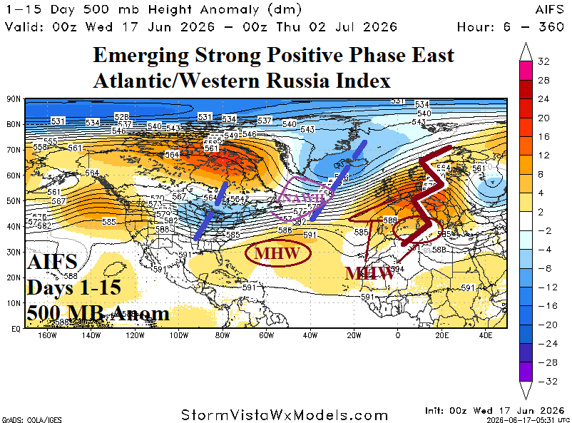
Positive phase of the East Atlantic/Western Russia (+EAWR) index is present when an amplified upper-level high pressure ridge emerges over Europe compensated for by a downstream upper trough near the Caspian Sea while a deep trough resides over the North Atlantic and a second high pressure area forms over Northeast China. Another related trough forms over the Midwest U.S. during the +EAWR regime.
06/16/2026, 8:55 am EDT

Tropical Storm Arthur Possible Off Texas Coast Briefly Tomorrow

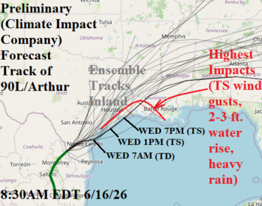
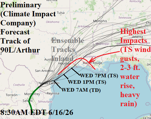
Low pressure area (90L) in Southern Texas will shift northeastward and organize into a center, likely a tropical depression, by 7AM EDT tomorrow of the central Texas Coast. Water temperatures are supportive (83F). Following ECMWF which takes this system northeast-to-north into Galveston Bay tomorrow evening. NOAA/NHC indicates 60% chance of an upgrade to a tropical storm (Arthur) while offshore and prior to reaching Galveston Bay. Forecast models indicate most of the attendant weather, as this system organizes, is east of the storm center.