
Tropical Storm Arthur Possible Off Texas Coast Briefly Tomorrow
06/16/2026, 8:55 am EDT
ECMWF Is Windy California and Texas to Midwest U.S. in July 2026
06/18/2026, 8:31 am EDT
Climate Impact Company North Atlantic Basin 10-Day Monitor
Issued: Wednesday June 17, 2026
Highlight: Tropical Depression One is a trouble-maker.
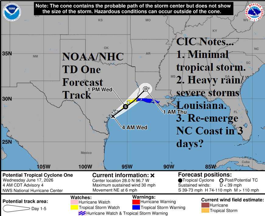
Fig. 1: NOAA/NHC forecast track for Tropical Depression One.
Discussion: At 5AM EDT, Tropical Depression One was located at 28.0N/96.7W or about 35 miles southwest of Port O’Connor, TX. TD 1 is moving northeast at 6 mph. The NOAA/NHC forecast track indicates northeast drift just offshore the immediate Texas Coast today moving inland tonight across the Upper Coast of Texas (Fig. 1). NOAA/NHC indicates a brief upgrade to a tropical storm (Arthur) before moving inland this evening. Tropical cyclone models generally doubt tropical storm intensity. A large area of extreme rain is located east of the depression (Fig. 2) shifting north and northeast to bring heavy rains to the Gulf States/Southeast U.S. the next 2-3 days (Fig. 3). Flash flood risk lingers into Friday across the Southeast U.S. (Fig. 4). Strong thunderstorms strike Louisiana today as TD 1 moves northeastward (Fig. 5). The moisture associated with TD 1 also enhances a tornado outbreak expected later today in the Midwest States. On Thursday, the moisture from TD 1 causes widespread strong to severe thunderstorms in the East U.S. (Fig. 6).
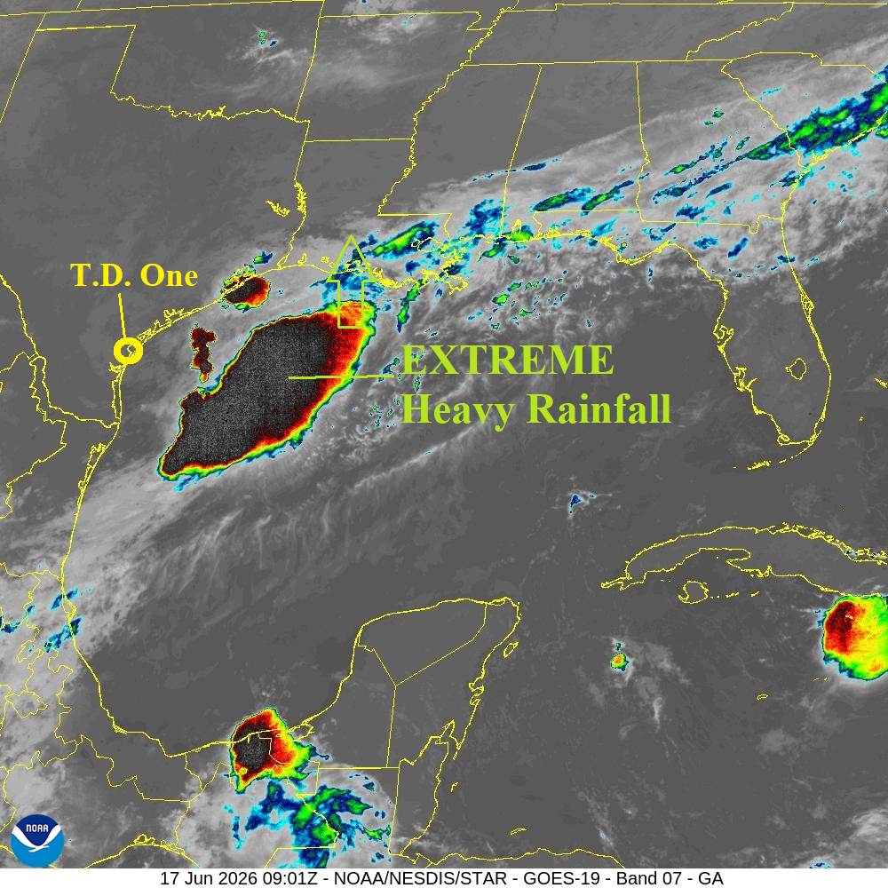
Fig. 2: Recent weather satellite view of the immense heavy rain located east of Tropical Depression One.

Fig. 3: NOAA/NHC rainfall projection associated with Tropical Depression One.
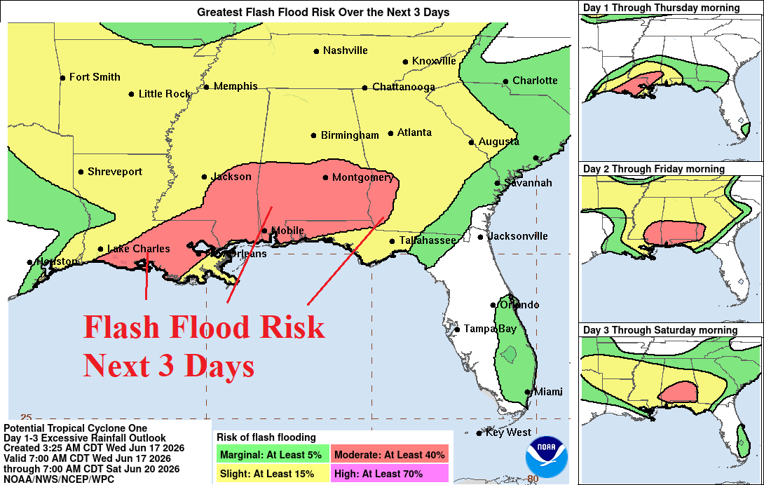
Fig. 4: NOAA/NHC flash flooding risk areas forecast for the next 3 days.
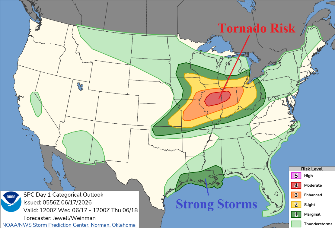
Fig. 5: Today’s severe weather outlook features a Midwest U.S. tornado outbreak risk.

Fig. 6: Tomorrow’s wide aerial coverage of strong to severe thunderstorms.

Climate Impact Company North Atlantic Basin 10-Day Monitor
Issued: Wednesday June 17, 2026
Highlight: Tropical Depression One is a trouble-maker.

Fig. 1: NOAA/NHC forecast track for Tropical Depression One.
Discussion: At 5AM EDT, Tropical Depression One was located at 28.0N/96.7W or about 35 miles southwest of Port O’Connor, TX. TD 1 is moving northeast at 6 mph. The NOAA/NHC forecast track indicates northeast drift just offshore the immediate Texas Coast today moving inland tonight across the Upper Coast of Texas (Fig. 1). NOAA/NHC indicates a brief upgrade to a tropical storm (Arthur) before moving inland this evening. Tropical cyclone models generally doubt tropical storm intensity. A large are of extreme rain is located east of the depression (Fig. 2) shifting north and northeast to bring heavy rains to the Gulf States/Southeast U.S. the next 2-3 days (Fig. 3). Flash flood risk lingers into Friday across the Southeast U.S. (Fig. 4). Strong thunderstorms strike Louisiana today as TD 1 moves northeastward (Fig. 5). The moisture associated with TD 1 also enhances a tornado outbreak expected later today in the Midwest States. On Thursday, the moisture from TD 1 causes widespread strong to severe thunderstorms in the East U.S. (Fig. 6).
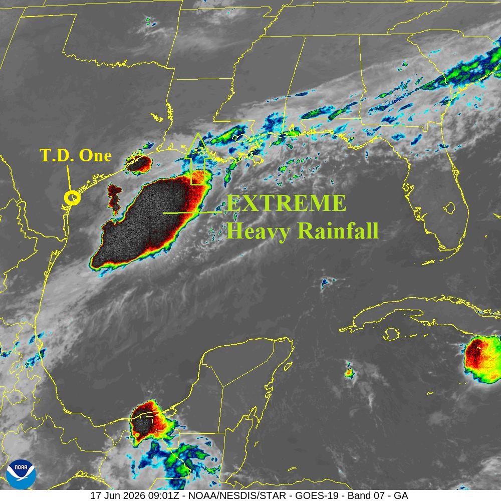
Fig. 2: Recent weather satellite view of the immense heavy rain located east of Tropical Depression One.

Fig. 3: NOAA/NHC rainfall projection associated with Tropical Depression One.
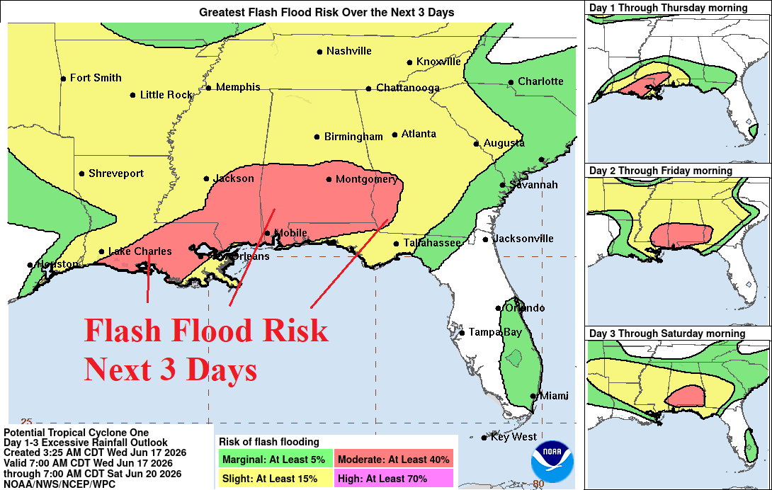
Fig. 4: NOAA/NHC flash flooding risk areas forecast for the next 3 days.
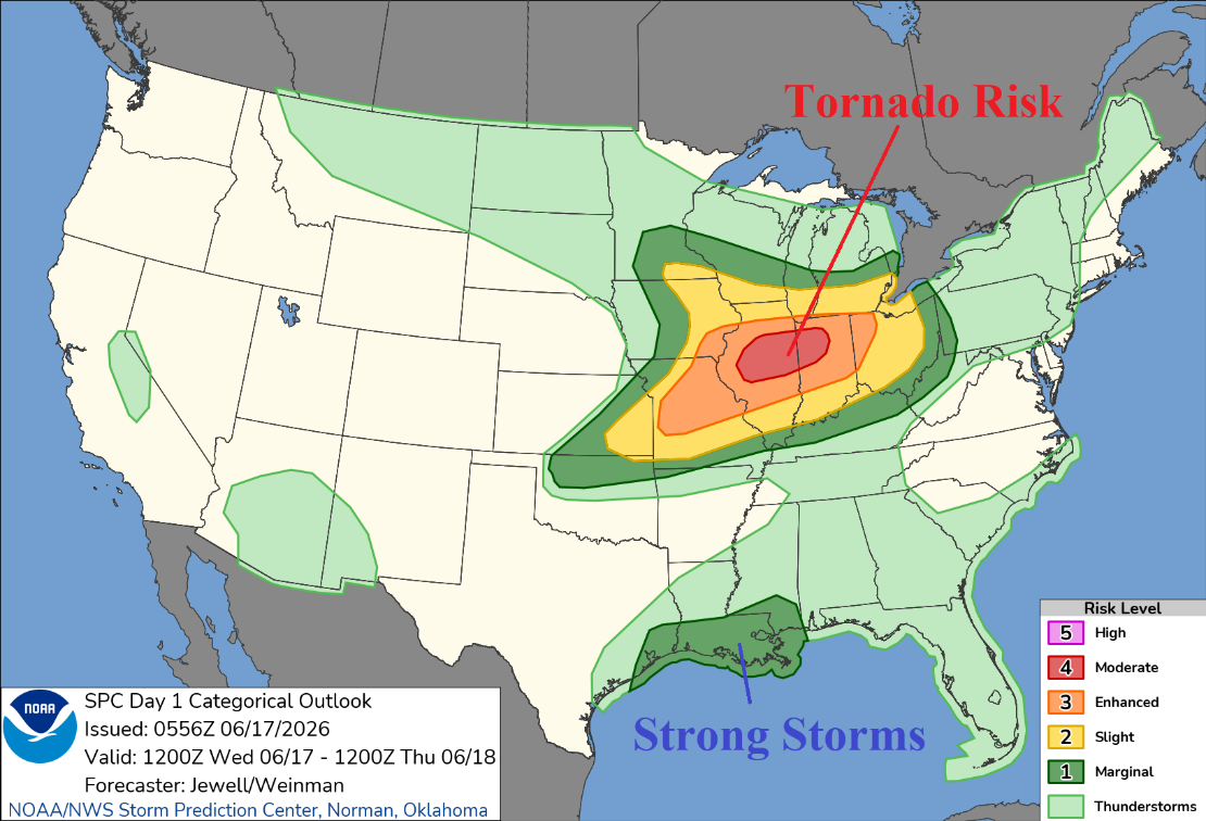
Fig. 5: Today’s severe weather outlook features a Midwest U.S. tornado outbreak risk.
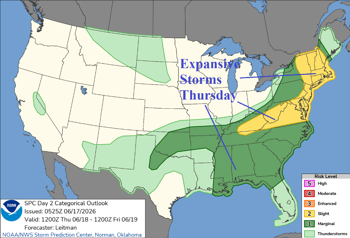
Fig. 6: Tomorrow’s wide aerial coverage of strong to severe thunderstorms.