
ECMWF Is Windy California and Texas to Midwest U.S. in July 2026
06/18/2026, 8:31 am EDT
Extreme Heat in Europe Eases by Early July
06/23/2026, 9:25 am EDT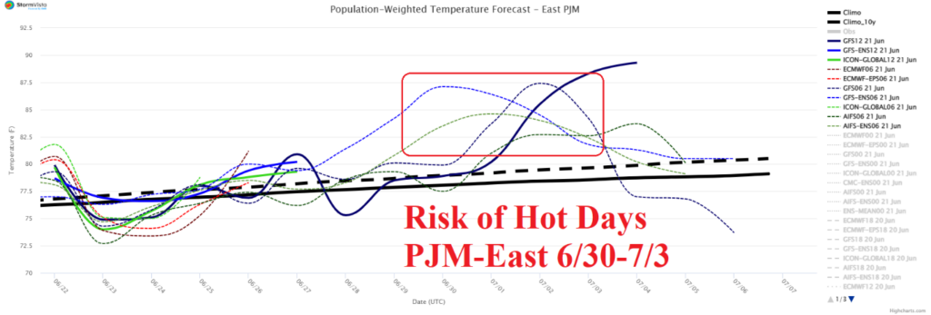


Climate Impact Company U.S. Sunday Report
Issued: Sunday, June 21, 2026
Highlight: PJM-East heatwave 6/30-7/3. AI models break heat extended range. 10-day forecasts bring rain to some drought areas.
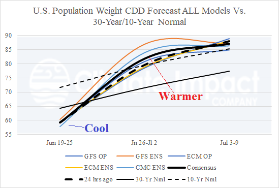
Fig. 1: U.S. population weight CDD forecast utilizing all models, their consensus, and comparing with yesterday’s forecast and 10-year/30-year climatology.
Discussion: The U.S. population weight CDD forecast for the week ending June 25th is somewhat below normal cooling demand, increasing dramatically the following week, and staying near the 10-year normal for the week ending July 9th (Fig. 1). GFS and CMC ensembles were the hottest forecasts for late JUN/early JUL. The estimated week 3-5 CDD forecast comparing ECM and CFS with 3 AI models is similar to late last week when ECM was the hot outlier and AI the cooler forecasts, near the 30-year normal, and CFS in between those solutions (Fig. 2). Climate signals and CIC-CA July 2026 forecast favor cooler solutions.
The U.S. Drought Monitor indicates 72% of the U.S. is affected by dry-to-drought soil conditions, down slightly from recent weeks. The daily U.S. soil moisture anomalies analysis reveals the harshest drought is in Nebraska, Oklahoma, and the Mid-Atlantic region (Fig. 3). The 10-day (ECM ENS) percent of normal rainfall indicates much needed precipitation is ahead for the Great Plains to New England stretch although (generally) missing the Mid-Atlantic States (Fig. 4).
Regarding short-term issues, a severe thunderstorm outbreak is forecast for today across the southern Great Plains to the southern Ohio Valley (Fig. 5). Tornadoes are possible in southern portions of Illinois and Indiana today. On Monday, severe weather risk shifts to the Mid-Atlantic region primarily is potential wind gust damage (Fig. 6). Severe storms are likely across the western Gret Plains later this week.
Finally, a lot of market interest on PJM-East heat risk for late June. The latest 15-day forecast reveals most models indicate heatwave potential (Fig. 7). ALL MODELS projects 93-95 for Washington, DC. GFS ENS is hottest at 98.
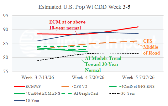
Fig. 2: Climate Impact Company estimated CDD’s utilizing ECM and CFS for week 3-5 ahead and 3 AI models for week 3-4 ahead.
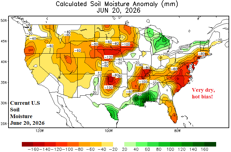
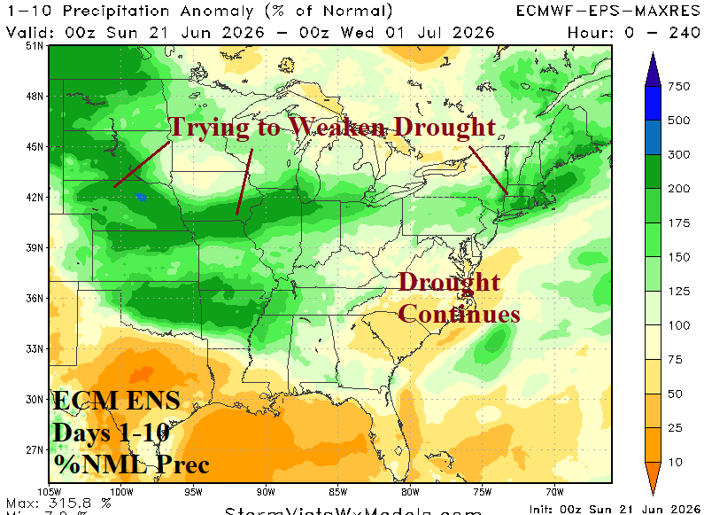
Fig. 3-4: NOAA/WPC U.S. 1-7-day quantitative precipitation forecast.
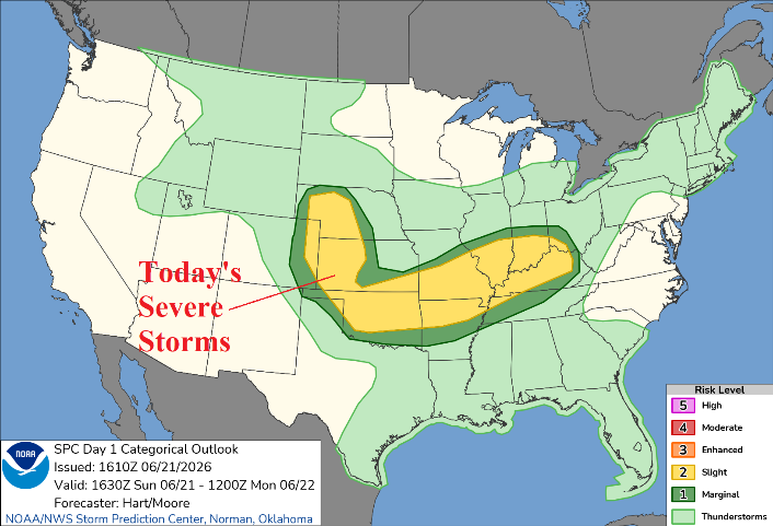
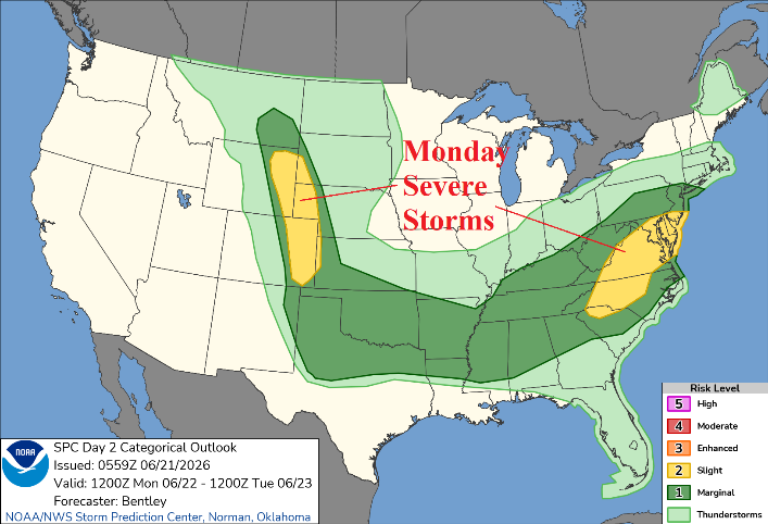
Fig. 5-6: NOAA/SPC severe weather areas for today and tomorrow.
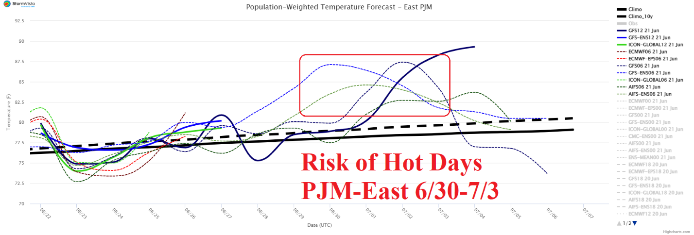
Fig. 7: PJM-East 15-day system daily average temperature forecast utilizing all models.