
Another Regenerating Europe Heatwave Ahead
07/01/2026, 1:08 pm EDT
Wetter Weather West/Southwest Europe Late Summer/Autumn
07/07/2026, 4:40 pm EDT

Climate Impact Company U.S. Sunday Report
Issued: Sunday, July 5, 2026
Highlight: 1, 602 severe weather/event reports FRI/SAT. More Mid-Atlantic severe storms today; Excessive rainfall event Northeast U.S. extends to Tuesday.

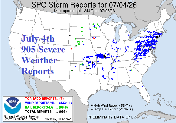
Fig. 1-2: NOAA/SPC severe weather/event reports for Friday and Saturday focused on NYC (Friday) and Washington/Baltimore/Philadelphia (Saturday).
Discussion: A cold front pushing into extreme heat was the catalyst for exceptionally violent severe weather outbreaks extending from the Ohio Valley to New York City on Friday (Fig. 1) and throughout the Mid-Atlantic region on Saturday (Fig. 2). NOAA/SPC tallied 1,602 severe weather events/reports for the 2 days.
NOAA/SPC severe weather outlooks for today regenerate significant risk of damaging wind in the DCA/BWI/PHL stretch again today (Fig. 3). Additionally, the stalled front triggering the adverse weather causes excessive rain and flood risk across Pennsylvania, New Jersey, Maryland, and Delaware today (Fig. 4). A repeat of excessive rainfall and flooding extends throughout the coastal Mid-Atlantic region on Monday (Fig. 5). NBM projects the most rainfall in the NYC area plus Connecticut through the next several days (Fig. 6).
The East U.S. heat weakens this week although staying hot in the Carolinas and likely to continue through the medium range. However, the heat core shifts westward to the Interior West in the 6-10-day period (Fig. 7) and expands/intensifies from California to the Great Plains in the 11-15-day period (Fig. 8). Note that the Costal Northwest and Northeast States avoid the regenerating anomalous heat.
U.S. population weight CDD forecasts stay hot over the weekend and are revised slightly hotter than yesterday through the middle third of July (Fig. 9). The ECM Operational (model) is hottest. The short-term CDD forecast is maintained in the week 3-5 outlook by ECM while CFS V2 and 3 AI models cool the northeast quadrant of the U.S. causing near normal CDD forecasts (Fig. 10). Mega-cluster ensemble favors the warmer scenario entering the 16-30-day period (47% confidence while 3 lesser likely ensembles support the cooler forecast.
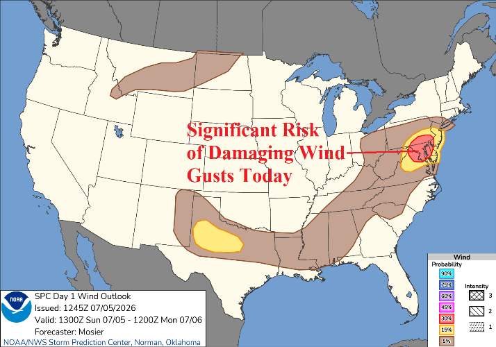
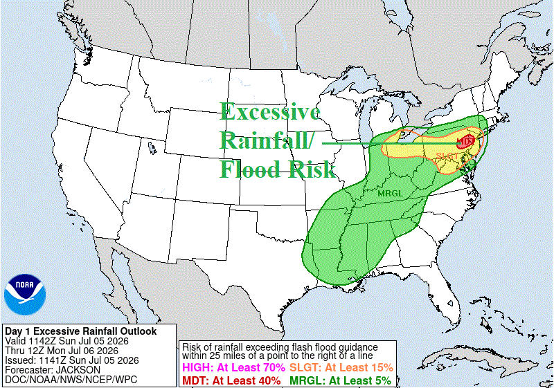
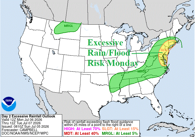
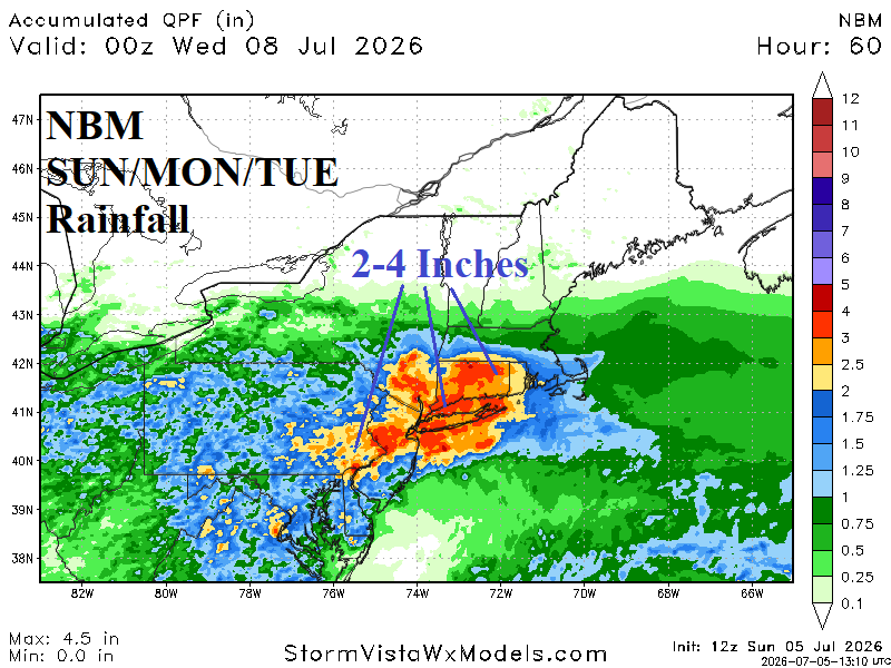
Fig. 3-6: NOAA/SPC significant risk of damaging wind gusts in the DCA/BWI/PHL stretch today plus NOAA/WPC excessive rainfall/flood risk areas for today and tomorrow. Also, the NBM 3-day rainfall amount forecast.
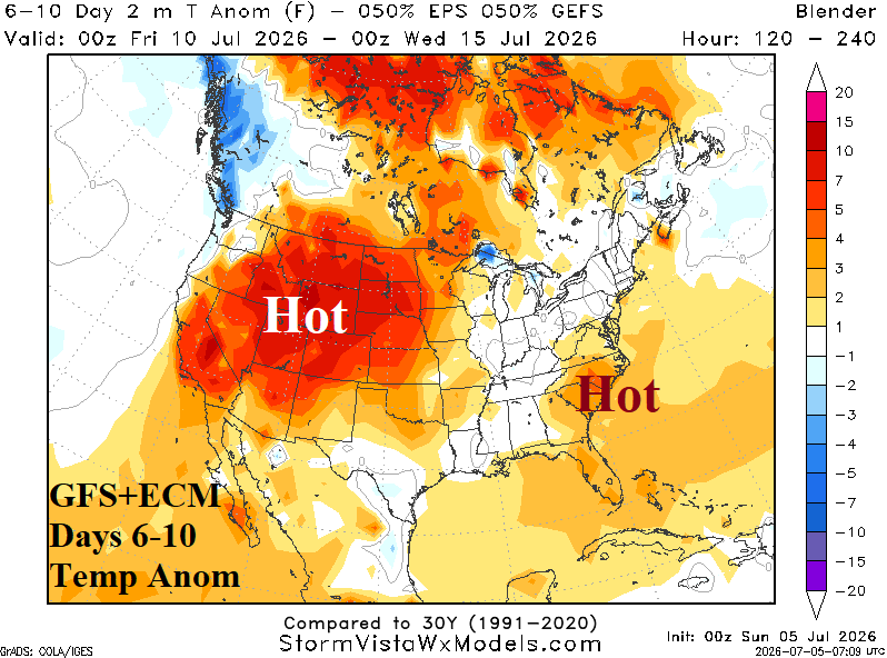

Fig. 7-8: GFS+ECM U.S. medium range temperature anomaly forecast.

Fig. 9: The U.S. population weight CDD forecast utilizing all operational models, their consensus, and comparing with 24 hours ago and the 30-year/10-year normal.

Fig. 10: Estimated U.S. population weight CDD for weeks 3-5 ahead utilizing ECM, CFS V2, and 3 AI models.