06/15/2026, 4:55 am EDT

Major Rainfall Event East Texas to Louisiana/Mississippi This Week

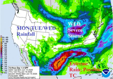
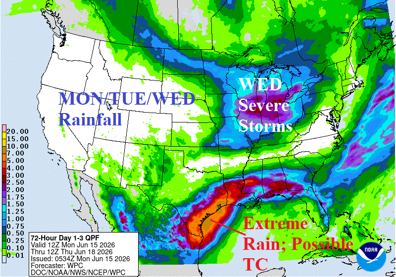
Remnants of a potent tropical wave are located over Southern Texas, and the attendant low-pressure area may drift off the Central Texas Coast midweek and become a tropical depression before moving back inland the northwest coast of the Gulf of Mexico later this week. Regardless, this system enhances an extreme rainfall event forecast for the length of the Texas Coast the next 3 days and East Texas to Mississippi for THU/FRI. NOAA/WPC indicates potential for 15+ inches of rain near and east of Houston this week with 5-10 in. from Corpus Christi, TX to Jackson, MS.
06/14/2026, 2:24 pm EDT

Cool/Wet U.S. AG Belt; Dangerous Heat and Dry West/Central Europe

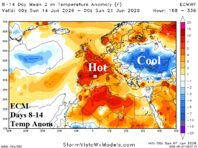
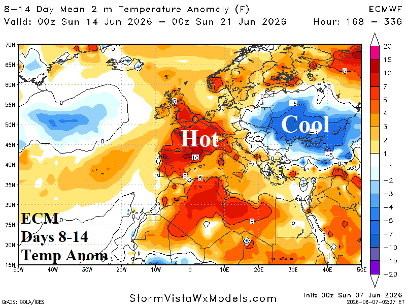
ALERT for significant anomalous heat and dryness emerges across West and Central Europe during the second half of June. To best illustrate the threat, the AIFS ENS is utilized. AIFS ENS has generally been the top or near the top model for skill scores during the past 30 days.
06/14/2026, 10:14 am EDT

Cold Risk Southeast Brazil 11-15 Days Out; West Africa Cocoa Continues Wet Pattern

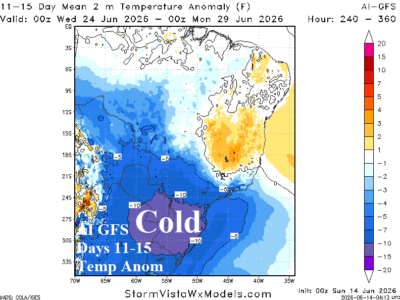
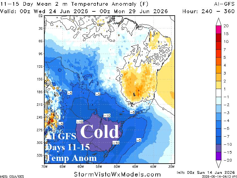
The 11-15-day temperature anomaly forecasts by ECM and AI GFS indicate significant cold risk in Argentina to southwest and southeast Brazil. Each model indicates the core of the cold is slightly different regions. In each scenario, the southern coffee growing areas of Brazil are very close to the <32F risk zone as indicated by ECM ENS. Other forecast models are cool but not as cold.
06/14/2026, 9:44 am EDT

Persistent Positive Phase Southern Annular Mode Causes Australia Wet Weather, Delays Drier El Nino Effect

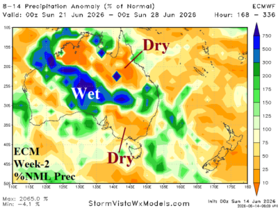
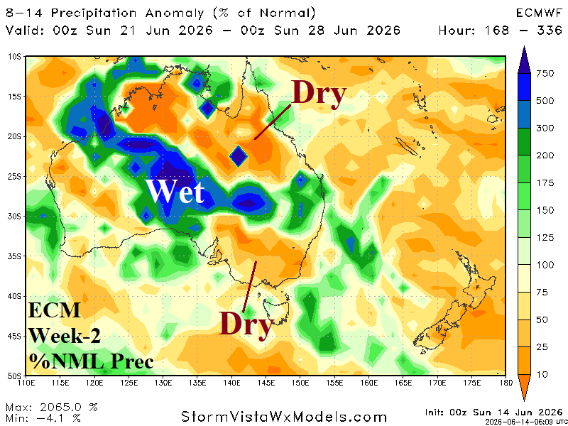
Although recent Australia climate was drier, the generally wet pattern of May/early June is likely to resume the next 2-4 weeks due to persistent positive phase Antarctic Oscillation(+AO)/Southern Annular Mode (+SAM) which is forcing wet upper troughs to navigate Australia and prevent drying effects from a developing El Nino climate. The drying effects from El Nino arrive later winter.
06/11/2026, 11:20 am EDT

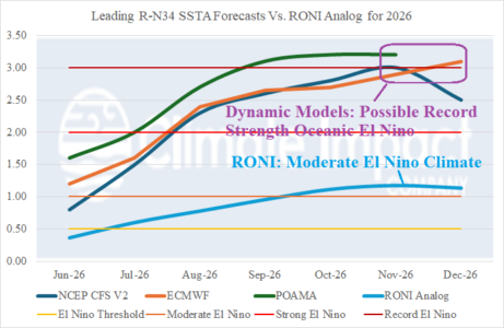
Possible Record Strength Oceanic El Nino in 2026 but ENSO Climate May Be Less Intense

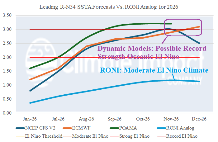
Traditional measurements of ENSO phase indicated El Nino onset during early Q2/2026. However, the new relative operational Nino index (RONI) is (now) used to determine ENSO strength and forecasts. Using RONI, NOAA identifies the presence of El Nino beginning in June. Dynamic models continue to forecast a potential record strength oceanic El Nino likely due to the immense upper ocean heat rivaling the 1997-98 El Nino as most intense on record. However, using a RONI analog, the ENSO climate may be less impressive and is followed by La Nina returning next year.
06/11/2026, 9:33 am EDT

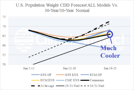
Cooler U.S. CDD Forecast for Later June

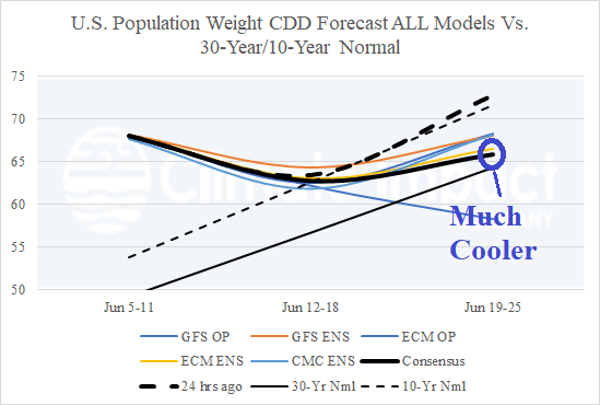
A forceful eastward shift of the MJO through the America Tropics causes a stronger mid-continent trough pattern as supported by a stronger -EPO/-WPO forecast in the medium-range supporting cooler changes in the Central U.S./Great Lakes region. The June 19-25 CDD forecast reflects the cooler change.
06/10/2026, 1:46 pm EDT

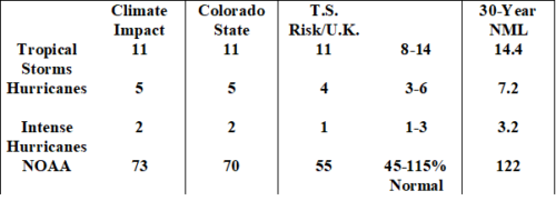
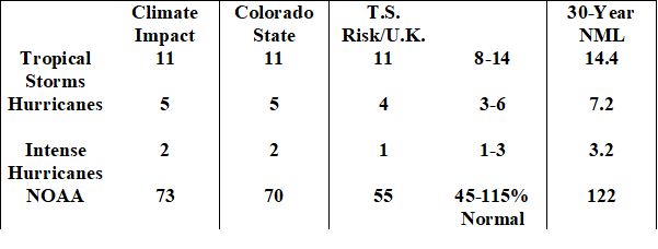
All Seasonal TC Forecasts Updated…Below Normal El Nino Year

The early June seasonal forecasts of tropical cyclone activity across the North Atlantic basin for 2026 are updated. Climate Impact Company, Colorado State University, and Tropical Storm Risk/U.K. each lower their seasonal totals from initial outlooks released in early April.
06/10/2026, 1:42 pm EDT

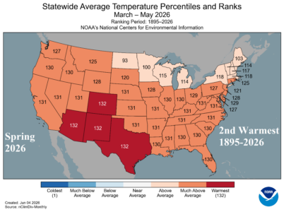
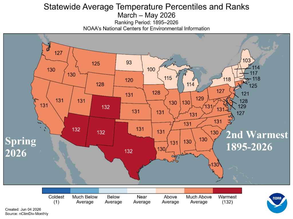
2nd Warmest Spring on Record in U.S. Trailing Only 2012

The second warmest meteorological spring on record was observed during MAR/APR/MAY 2026. The warmest on record was observed in 2012, the year of a prohibitive drought. All-time record-warmth was observed in Arizona, New Mexico, Colorado, and Texas for meteorological spring. The remainder of the contiguous U.S. was MUCH ABOVE normal except marginally ABOVE normal for the Upper Midwest to New England States.
06/09/2026, 8:03 am EDT

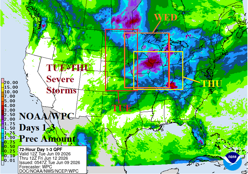
Severe Weather Alley…North-central/Midwest/South-central U.S. This Week

In the 3-day forecast, heavy rain is centered on North Dakota to the far eastern Canadian Prairies plus Illinois. Severe storms produce much of the rain. An unusually high tornado risk for North Dakota today. An equally high tornado risk tomorrow is centered on the Iowa/Illinois/Wisconsin region. St. Louis to Chicago tornado risk is indicated for Thursday.
06/07/2026, 9:42 am EDT

The Heathrow/Paris Vs. Berlin CDD Forecast Divide!

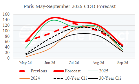
The May 2026 CDD at Heathrow and Paris were prohibitively warm! A whopping 61 CDD was observed in Paris due to a record (May) heat spike compared to 12 and 15 30-year/10-year climatology. The June 2026 CDD forecast for both Heathrow and Paris remain hot with strong increases in CDD count from the previous (May) forecast. Note that May, June, and July (Paris) are hotter (CDD) forecasts than last year’s totals.