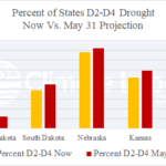
Slow Expansion of Great Plains D2-D4 Drought
04/30/2026, 12:17 pm EDT
Broadening U.S. Warmth Ahead; Includes Mid-Atlantic
05/05/2026, 9:24 am EDT
Climate Impact Company U.S. Month 1-4 Ahead Outlook
Issued: Monday, May 4, 2026
Highlight: Summer 2026 features dangerous Northwest/West heat and dryness but a stronger than normal Southwest U.S. wet monsoon; Midwest rains suppress summertime heat risk; Late summer drought Mid-south to Texas.
Executive summary: The Climate Impact Company month 1-4-ahead climate outlooks valid for June through September are updated. The forecast is based on developing El Nino, the warm Northeast Pacific influence, soil moisture regime, and optimum climate normal. The outlooks indicate a hotter than normal summer season across much of the U.S., especially the Northwest to California and Gulf States while wet climate suppresses anomalous heat risk in the Midwest. Drought expands northwestward in the West and develops Mid-south to Texas later in the summer season.
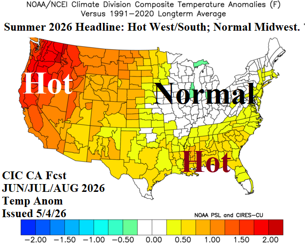
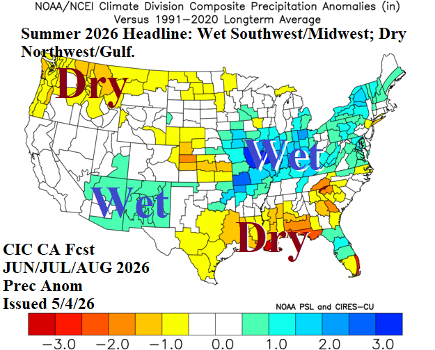
Fig. 1-2: The Climate Impact Company constructed analog JUN/JUL/AUG 2026 temperature and precipitation anomaly forecast.
Discussion: The clear top analog year is 2015 when both the Northeast and tropical East Pacific were warming to unprecedented levels. 2026 will challenge the 2015 “warm blob” and El Nino year for warmest basin SSTA on record. A second category of analog(s) regards soil moisture. About 75% of the U.S. is experiencing dry-to-drought conditions with nearly 20% of the U.S. observing severe drought. Only the Great Lakes region is soaking wet. Similar analog years from the past 30 years include 2000, 2002, 2006, 2008, and 2022. Each (analog) year has similarities but averaged together is reasonably close to early May 2026. Since the 2013-16 “warm blob” in the Northeast Pacific, presence and persistence of marine heatwaves outside of the tropical oceans have increased. The warming mid-latitude oceans have accelerated global oceanic warming during the past 10-15 years which began in the 1980’s. Consequently, an optimum climate normal (OCN) is added to the constructed analog forecast process which features ENSO, similar mid-latitude SSTA, soil moisture, and OCN.
June 2026 outlook: Early wet monsoon rainfall develops across the Southwest U.S. Pieces of the tropical moisture are ejected northeastward to fuel a wet early summer across the Midwest and into the Northeast. The Midwest and Northeast rainfall will suppress anomalous heat risk in June. An upper-level high-pressure ridge shifts to the Northwest U.S. propelling hot and dry weather likely to extend to Southwest Canada. An upper ridge pattern also promotes anomalous heat and dryness across the Southeast U.S. drought region. The Texas forecast could be hotter than indicated unless the outlook is wetter than indicated.
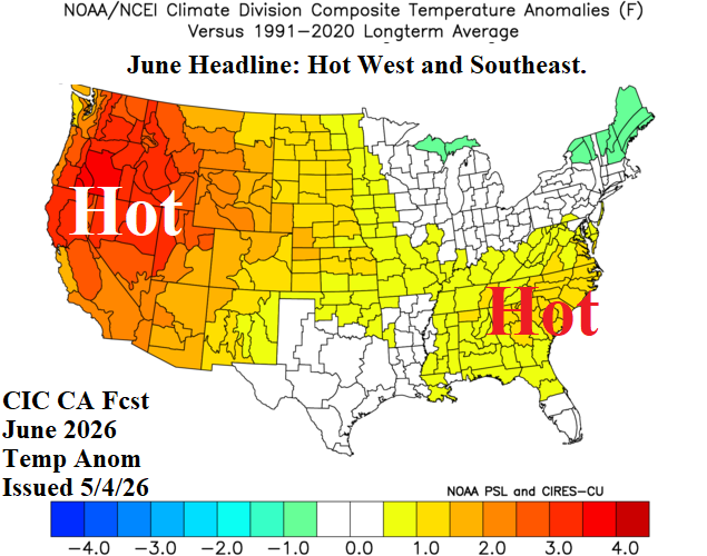
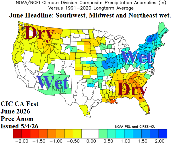
Fig. 3-4: The Climate Impact Company constructed analog June 2026 temperature and precipitation anomaly forecast.
July 2026 outlook: The Mid-summer 2026 forecast widens anomalous heat and dryness in the Gulf region. Wet weather extends from the ongoing wetter than normal Southwest U.S. Monsoon to the Midwest States. The wet areas generate suppressed mid-summer heat risk. The Northwest to North-central U.S. remains a hot and dry zone.
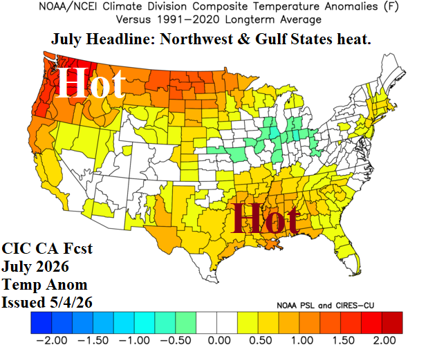
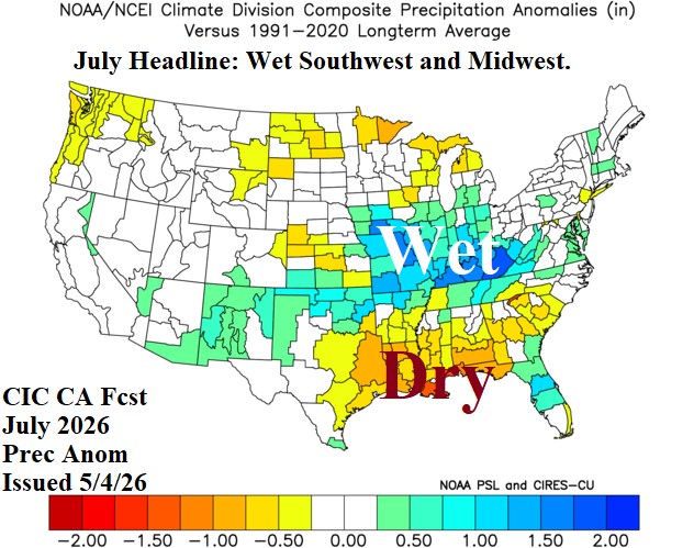
Fig. 5-6: The Climate Impact Company July 2026 temperature/precipitation anomaly outlook utilizes CFS V2 “monthlies” as the “best” forecast.
August 2026 outlook: The Midwest maintains near to cooler than normal summer climate while anomalous heat risk persists in the West and Texas. The central Plains to Texas are turning drier. The Northeast Corridor shifts drier and hotter.
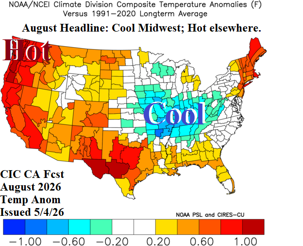
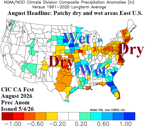
Fig. 7-8: The Climate Impact Company constructed analog August 2026 temperature and precipitation anomaly forecast.
September 2026 outlook: Late calendar summer brings very warm to hot weather across the Central U.S. extending to the Northeast States. Late season dryness will spawn drought in the Mid-south/Texas region. Implied is lack of Northwest Gulf tropical cyclone activity.
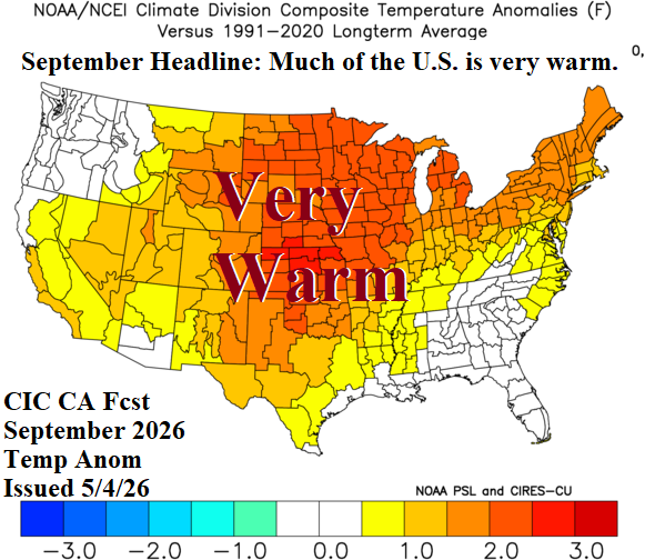
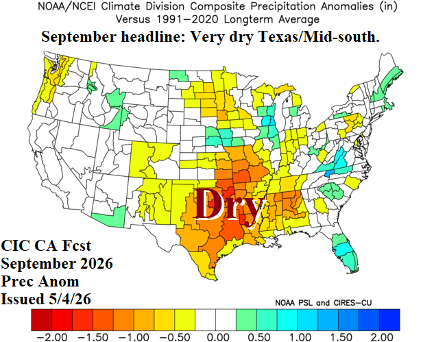
Fig. 9-10: The Climate Impact Company constructed analog September 2026 temperature and precipitation anomaly forecast.