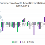
Persistent 2007-19 –NAO Pattern During Summer May Reverse for Summer 2020
06/12/2020, 1:39 pm EDTWhy The Tropics Should Become More Active Later July
07/12/2020, 11:26 am EDT
Discussion: Research (AMS/Journal of Climate 2/15/18) has shown one of the key predictors of increased North Atlantic tropical cyclone activity since 1995 is the increased mid-atmospheric relative humidity at the onset of tropical cyclone season. The increased mid-atmospheric moisture is attributed to the tendency for a warmer-than-normal ocean surface. A warmer-than-normal ocean surface and above normal mid-atmospheric moisture enhances tropical cyclone development risk. Pictured is precipitable water anomalies at 600 MB for June 1-July 6, 2020 which identifies moderate to very high moisture content above the Gulf of Mexico and central/outer tropical/subtropical North Atlantic basin (Fig. 1). Implied is a generally very buoyant mid-atmosphere for tropical cyclone development (in the tropics) for the season ahead. As a reference the 6/1-7/6, 2005 chart (which was followed by the most active TC season on record for the North Atlantic) is posted.
In 2005 a total of 28 tropical storms, 15 hurricanes and 7 intense hurricanes smashed all-time records for seasonal TC activity in the North Atlantic basin. During 6/1-7/6, 2005 (Fig. 2) the precipitable water (available moisture) in the middle atmosphere (600 MB) was excessive. The high water content mid-atmosphere present largely due to a warmer than normal ocean surface was the catalyst to the extremely dangerous TC season that followed. Historically, La Nina is attributed to the most active TC seasons in the North Atlantic however neutral ENSO was present in 2005
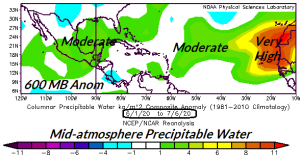
Fig. 1: June 1 to July 6, 2020 available moisture at 600 MB across the tropical/subtropical North Atlantic basin indicates moderate to much above normal amount which is favorable for tropical cyclone activity.

Fig. 2: June 1 to July 6, 2005 available moisture at 600 MB across the tropical/subtropical North Atlantic basin was buoyant and foreshadowed the most robust tropical cyclone season on record.