Indian Ocean Dipole (-IOD) AND La Nina Increases Risk of Stronger La Nina Climate AND La Nina Lingering Into Next Year
05/25/2020, 10:15 am EDT
A Key Predictor of Seasonal Tropical Cyclone Activity
07/10/2020, 5:33 pm EDT
Highlight: Persistent 2017-19 –NAO pattern during summer may reverse for summer 2020.
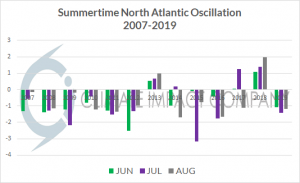
Fig. 1: The summertime North Atlantic oscillation has been mostly in the negative phase since 2007 except for 2013 and 2018.
Discussion: During the past 13 years the summertime North Atlantic oscillation has almost always been in the negative phase (Fig. 1). On average, the upper air pattern in the northern hemisphere related to this climate signal has featured a warm upper ridge in the polar region, cool upper trough west of Europe and a compensating upper ridge over the Black Sea region (Fig. 2). In North America the ridge pattern has affected the Southwest U.S. while Northeast Asia has also observed an upper ridge pattern. Beneath the ridge patterns summer has a tendency to be hotter and drier than normal and sometimes produces drought. The pattern described was projected to return for summer 2020 with climate forecasts issued earlier this year.
However, there are two years within the 2007-2019 optimum climate normal when just-the-opposite occurred…a positive North Atlantic oscillation inspiring a deep cold trough over the polar region and an elongated upper ridge to the south extending across the West U.S. and southern Canada plus northern Europe (Fig. 3). In this pattern periods of hot weather are more common just south of the jet stream axis in the middle latitudes while areas farther south (Southern Europe, Black Sea and southern Russia) are temperate and sometimes wet.
Currently, the June NAO forecast is positive phase and the upper air forecast over the next 15 days indicates an elongated low pressure trough stretching from northeast Canada across the polar region and into North-central Russia (Fig. 4). Implied is the tendency of the Europe ridge to reside over Northwest Eurasia may continue while downstream an upper trough persists in southern Russia occasionally extending to the Black Sea region. The U.S. pattern is transitory and can produce days of extreme heat followed quickly by cooling cold fronts.
If the +NAO pattern holds to August, the 2013/2018 analog suggests the Greenland trough amplifies and is compensated for by an equally impressive expanding Europe ridge (Fig. 5). Europe into Western Russia are hot and dry in this upper air set-up. Also notable is the sprawling Bermuda High in the North Atlantic basin providing deep tropical easterlies to the south to guide tropical cyclones westward toward the U.S.
Summary: The summer 2020 projected upper air pattern was confident that a Greenland blocking high pressure ridge would form to the north of a cool trough west of Europe across a cool SSTA zone (south of Greenland) compensated for by a drought-producing upper high in the Black Sea region. Instead just-the-opposite occurred…a lingering polar vortex (+NAO pattern). Implications are a farther north upper ridge pattern for Europe leaving the Black Sea region susceptible to showers and suppressed heat. In the U.S. periods of very hot weather can occur quickly broken by cooling fronts. The deep tropics have due west steering currents provided by a strong and elongated Bermuda High.
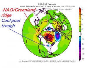
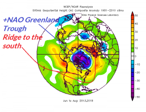
Fig. 2-3: Typical upper air features for the northern hemisphere 2007-2019 when –NAO has been in-place (left) and the two years (2013 and 2018) when +NAO has dominated.
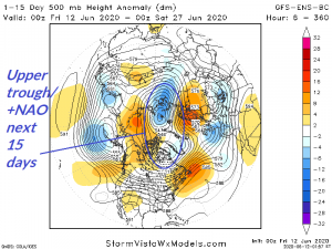
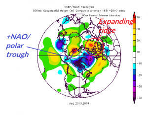
Fig. 4-5: The GFS ENS day 1-15 northern hemisphere upper air pattern forecast (left). Recent analog years when +NAO occurred in August and the attendant upper air pattern.