Madden Julian Oscillation Inspires Atmospheric River Storm Track To Develop
01/21/2024, 11:40 am ESTAnother Stratospheric Warning Event Generating Arctic Air Mid-February?
02/02/2024, 8:24 am EST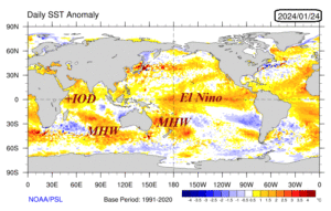

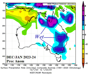
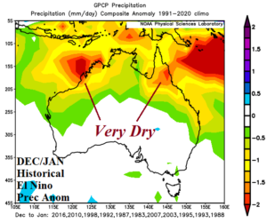
Fig. 1-4: The current global SSTA analysis identifying marine heat waves near Australia and the attendant upper air pattern since Dec. 1, 2023 (above) and the DEC/JAN 2023-24 anomalous rainfall across Australia compared to typical rainfall associated with El Nino.
Discussion: Marine heat waves (MHW) southwest and east of Australia are strengthening during the summer season so far and affecting the prevailing upper air pattern governing the attendant Australian climate (Fig. 1). The precipitation climate across Australia so far this summer season is much different from a typical El Nino climate! The summertime prevailing upper air pattern has featured a semi-permanent high-pressure area south and south of Australia with a second center near New Zealand (Fig. 2). In-between the high-pressure areas, a wet subtropical upper-level low-pressure trough has become semi-persistent over Australia. The result is frequent heavy thundershowers across North and East Australia while dryness normally associated with El Nino summer is pushed to northwestern continent (Fig. 3). Typically, an El Nino DEC/JAN rainfall pattern is exceptionally dry across the northern continent with some of that dryness extending to both the West and East Coast (Fig. 4). Another example of the influence on climate by MHW to match or exceed ENSO effects.