Marine Heat Waves and Attendant Upper Air Pattern Influence on Australia Climate
01/28/2024, 1:08 pm ESTUpdating The -AO/-EPO Forecast for After Mid-February; Will Arctic Air Return to North America?
02/04/2024, 9:31 am ESTCharts of the day: Monitoring potential arctic air in North America.
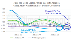
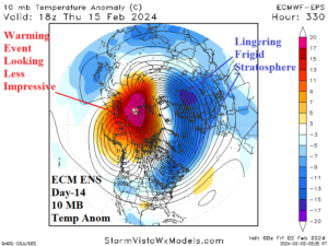
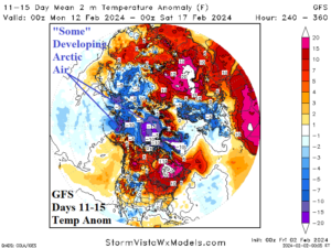
Discussion: Earlier this week, the GFS (model) indicated a developing arctic air mass in Siberia with potential for cross polar airflow into North America beginning in mid-February. The set-up had similarities to the December and January stratospheric warming events each inspiring Eurasia arctic air masses of which the second event (in January) travelled cross-polar into the U.S. The stratospheric warming supporting the mid-February potential was not as strong as the prior 2 events nevertheless deserving monitoring respect. On January 31st, the arctic oscillation (AO) and East Pacific oscillation (EPO) were both in the -1.5 range for mid-February supporting development of a potential North America “polar vortex” episode. During the past couple days forecast models have backed off this potential scenario. One problem is while stratospheric warming remains indicated over Northeast Asia/Northwest America in 2 weeks, there is also a much larger lingering colder than normal stratosphere on the North Atlantic side of the North Pole limiting the ability of the stratosphere to create conditions in the troposphere beneath to cause arctic air to form. The GFS indicates gathering cold in the 11-15-day forecast across northwest and north portions of North America but to compensate, the air mass to the south of arctic chill stays warm across the remainder of Canada and into the U.S.
Week-2 Ahead Forecast valid February 11-17, 2024: Still mild, drier.
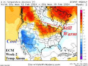
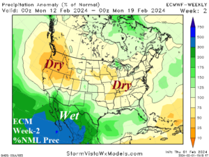
Discussion: The outlook is remarkably similar with the previous forecast. During mid-February, the super warm pattern is easing but not ending while the U.S. trend is drier as the storm track shifts farther south.
Week-3 Ahead Forecast valid February 18-24, 2024: Important cold risk still there but diminished.
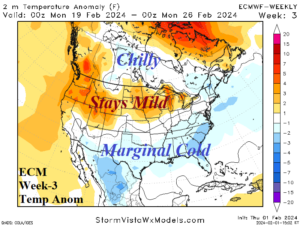
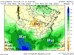
Discussion: Risk of important cold during the week of Feb. 18-24 is not eliminated but lowers from forecasts issued earlier this week. The storm track remains immense and shifts north slightly affecting all of the southern states.
Week-4 Ahead Forecast valid February 25-March 2, 2024: El Nino storm track roars on.
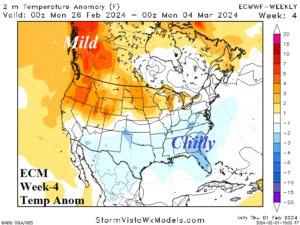
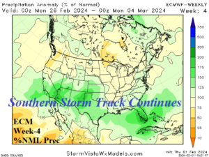
Discussion: The upper air pattern prevents extreme cold during late February. The El Nino storm track remains potent across the Southern U.S. generating locally chilly air due to steady cloud cover and precipitation.