Another Stratospheric Warning Event Generating Arctic Air Mid-February?
02/02/2024, 8:24 am ESTMost Negative Daily Southern Oscillation Index of El Nino 2023-24 Spawns California “Bomb Cyclone”
02/06/2024, 2:29 pm ESTDiscussion: Around February 17-18, temperatures are forecast to plummet to -40F to -50F in Siberia to Mongolia as rapid onset of an arctic air mass develops in response to stratospheric warming stretching from Siberia to the polar region and northwestern North America. Stratospheric warming enhances an evolving negative arctic oscillation (-AO) beginning later this week followed by emergence of a moderate to strong negative East Pacific oscillation (-EPO). -AO implies presence of a high latitude blocking high pressure system forcing a split in the polar vortex southward and out of the polar region. -EPO evolution indicates development of a high-pressure ridge over northwest North America, sometimes referred to as the “ridge bridge” if this feature settles over Alaska. To compensate for the high-pressure ridge, a polar vortex develops downstream over central North America. The AO/EPO 16-day forecast indicates -AO and -EPO exceed -1.5 beginning Feb. 18-20. Implied is presence of a “ridge bridge” to potentially tap that Siberia cold and send it cross-polar into the North America polar vortex QUICKLY during the week of Feb. 18-24. The U.S. arctic outbreak of mid-January was impressive with greatest impacts on the Central U.S. This event had more time to develop and a larger arctic air reservoir in Eurasia to encourage cross-polar into North America. The AO/EPO index for the mid-January arctic outbreak was -3.3/-1.9 respectively. Current AO/EPO forecasts are in the -3.0/-1.7 range. Although forecast confidence is increasing, to 2.5 on a 1-5 scale (up from 1.5 last week), there are a couple of problems. The “ridge bridge” over Alaska is a little too far to the east suggesting the set-up for cross polar flow of arctic air is not ideal or brief plus the Siberian arctic air mass is potent but just starting to evolve. Certainly, a pattern change is ahead for North America but arctic air involvement while possible is still in question.
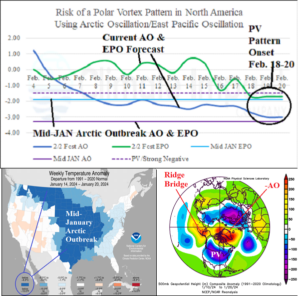
Fig. 1-3: The arctic oscillation and East Pacific oscillation 16-day forecast both will dip below -1.5 by February 16-18 implying development of a North America polar vortex pattern. The mid-January arctic outbreak was supported by an upper air pattern featuring an Alaska “ridge bridge”, high latitude blocking high pressure in the polar region, and a polar vortex over central North America.