Updating The -AO/-EPO Forecast for After Mid-February; Will Arctic Air Return to North America?
02/04/2024, 9:31 am ESTNorth America and Europe Winter 2023-24 Are Examples of Climate Change
02/15/2024, 7:27 pm EST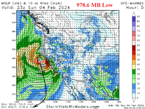
Fig. 1: GFS projection of a 979 MB “bomb cyclone” off the northern California Coast last Sunday (Feb. 4) afternoon.
Discussion: The short-term forecast of low pressure to the “bomb cyclone” embedded within an “atmospheric river” storm track in the Northeast Pacific was 979 MB off the north coast of California Sunday afternoon, Feb. 4th (Fig. 1). Using the old Saphir-Simpson hurricane force wind and pressure chart, a pressure this low equates to a category-1 hurricane capable of producing 64-82 knot wind speeds. Wind gusts across California during storm peak yesterday were in that range as widespread power outages occurred. The intense low pressure was caused by the phasing of the polar and subtropical jet stream off the California Coast which included an attachment by the subtropical Jetstream to tropical East Pacific where anomalous convective storms related to the Madden Julian oscillation were present (Fig. 2). Note the convection associated with the MJO in the southern hemisphere tropics (Fig. 3). The surge of MJO convection into the tropical East Pacific was enhanced by the warmer than normal waters associated with El Nino. The combination of these factors caused the strongest El Nino-like (negative) daily southern oscillation index (-SOI) of winter 2023-24 dipping to -4.1 on Feb. 5 (Fig. 4). The MJO surge into the tropical East Pacific is the strongest 5 (MJO) episodes dating back to last August (Fig. 5).


Fig. 2-3: The Madden Julian oscillation is immense in the tropical Pacific Ocean and causal to the “bomb cyclone” off the California Coast earlier this week.

Fig. 4: The most El Nino-like southern oscillation index of winter 2023-24 coincided with the California “bomb cyclone”.

Fig. 5: The latest surge of MJO convection into the tropical East Pacific is the 6th since last August and strongest!