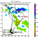
The Inaugural South America Year-2 Ahead Climate Forecast
01/30/2024, 2:27 pm ESTConsistent Forecast: Europe Turns Wintery Cold Again Mid-February
02/01/2024, 5:30 am EST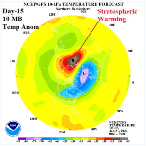
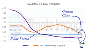
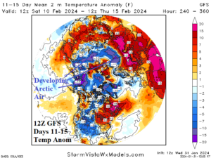
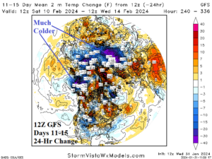
Fig. 1-4: The NCEP/GFS 10 MB temperature anomaly forecast for day-15, arctic oscillation and East Pacific oscillation 16-day forecast, 12Z GFS northern hemisphere temperature anomaly forecast, and 24-hour change.
Discussion: Beginning 2 days ago, stratospheric warming began to appear across Siberia northward to the North Pole at the end of the 11-15-day forecast. Models are now running consistent with this feature since that time as indicated by NCEP/GFS on day15 (Fig. 1). Stratospheric warming indicates arctic air development at ground level. Climate signals are trending in the direction of a polar vortex (PV) pattern forming as arctic oscillation is consistently strong negative once the middle third of February arrives and the East Pacific oscillation (EPO) is near a strong negative value by mid-February indicating potential onset of a polar vortex (Fig. 2). Today’s 12Z GFS jumped on the potential cold scenario. The 11-15-day forecast indicates arctic air emerging quickly beneath the stratospheric warming in Eurasia (Fig. 3). Some of that air is already traveling cross polar into North America according to the 12Z GFS. Note the 24-hour temperature anomaly change across Eurasia, which is much colder indicating this new cold solution represents potential for a major pattern change (Fig. 4). The presence of the -EPO forecast is important. If the strong negative EPO values develop and are persistent, a PV pattern is likely. Bottom line? The third stratospheric warming episode of northern hemisphere winter 2023-24 is developing in 10+ days. Unclear is whether this event will persist and produce arctic air masses similar with the early December (Eurasia to China) and early January (Eurasia to North America) episodes. The GFS model is very inconsistent but is usually the first model to note a pattern change. Close monitoring of forecast model solutions for mid-February is paramount. An arctic outbreak “watch” is necessary.