Extreme Rainfall Episode Northwest Gulf States Continues
01/24/2024, 5:46 am ESTEquatorial Pacific Upper Ocean Heat Plummeting
02/01/2024, 9:14 am EST 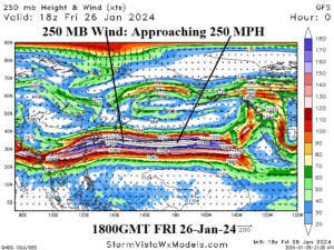
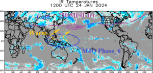
Fig. 1-2: GFS 250 MB wind speed at 1800 GMT on Jan. 26, 2024 and a weather satellite view of the global tropics and subtropics identifying presence of Madden Julian oscillation north and northeast of Australia.
Discussion: Late last week, there were reports of record-fast speed of jet airliners crossing the Pacific Ocean propelled by an unusually intense jet stream. Typical air speed of jet airliners flying at 37,000 to 41,000 feet is in the 550-600 mph range. Late last week, reports of air speeds near 825 mph were reported enabling trans-Pacific flights to arrive 90 minutes earlier than scheduled. The GFS 250 MB (34,000 feet) wind speeds at 1800 GMT this past Friday were approaching 225 mph (Fig. 1) and likely a little faster, near 250 mph, higher in the atmosphere where fantastic jet speeds were reported. What caused the historic jet stream strength? The jet stream speeds are normally very strong mid-to-late winter exiting Southeast Asia due to the thermal contrast in the atmosphere between the tropics across the very warm Indian and West Pacific Ocean(s) and frigid conditions to the north across Eurasia. However, that common presence was enhanced by super latent heat release poleward from heavy convection in the tropical West Pacific (Fig. 2) related to the Madden Julian oscillation (MJO). The MJO event was made stronger by the presence of oceanic warming in the tropics related to El Nino. The MJO event is the strongest of the El Nino 2023-24 regime and responsible for 3 southern hemisphere tropical cyclones (Anggrek, Candice, and Kirrily) while activating an “atmospheric river” heavy precipitation pattern into the North America West Coast. The MJO is forecast to weaken approaching the Dateline in early February.