Explaining Recent Tendency for Stalled U.S. Coastal Tropical Cyclones
05/31/2020, 2:19 pm EDTGlobal Soil Moisture Anomaly Analysis for May 2020
06/07/2020, 2:50 pm EDTSummary of the Climate Impact Company 2020 North Atlantic Tropical Cyclone Season Forecast
Highlight: Busiest year since 2010 and 2012. Several Gulf hurricanes are indicated. Many close calls for the U.S. East Coast.
Executive summary: The FINAL Climate Impact Company 2020 North Atlantic basin tropical cyclone season is issued. The forecast intensity has increased now indicating 20 tropical storms, 10 hurricanes and 4 intense hurricanes. The season is projected as the busiest since 2010 and 2012. The accumulated cyclone energy index is raised to 149. Several hurricanes are forecast to affect the Gulf of Mexico, at least one making landfall in the Carolinas and several developing near the Bahamas but staying offshore. August appears to be the most dangerous month. The forecast is based on the enhancing influence of a developing La Nina and warmer than normal North Atlantic basin.
| Tropical Storms | Hurricanes | Major Hurricanes | ACE Index | |
| 6/2/20 FCST
| 20 | 10 | 4 | 149 |
| 4/2/20 FCST | 16 | 8 | 3 | 128 |
| 15-YR NML | 15.5 | 7.3 | 3.1 | 15.5 |
| 30-YR NML | 13.8 | 7.0 | 3.0 | 13.8 |
| 50-YR NML | 12.0 | 6.2 | 2.5 | 12.0 |
| Last Year | 18 | 6 | 3 | 130 |
Table 1: The Climate Impact Company 2020 North Atlantic basin seasonal tropical cyclone activity forecast.

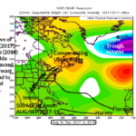
Fig. 1: The Climate Impact Company projected hurricane development areas and tracks plus the latest seasonal activity forecasts.
Regional forecast discussions: The Climate Impact Company 2020 seasonal tropical cyclone forecast for the North Atlantic basin hurricane development areas and prevailing tracks are ominous. Four primary hurricane development regions are projected for the 2020 season: 1.) Southeast Gulf of Mexico, 2.) Central and eastern Caribbean Sea, 3.) The Bahamas and 4.) The outer North Atlantic tropics. Ten hurricane tracks are projected. The forecast assumes Cristobal does not reach hurricane strength. Several Gulf of Mexico hurricanes are indicated. Two long-distance travelers are forecast…across the Caribbean to the Bay of Campeche and from the Cape Verde Islands to Carolina coast. Each of these long-distance travelers are likely major hurricanes. Several hurricanes also form in the Bahamas before drifting northeastward staying off the East Coast. The Gulf of Mexico is likely to observe at least one major hurricane.
- Gulf of Mexico: An exceptionally intense season with many tropical threats and at least 3 hurricanes of which 1 or 2 could become major hurricanes.
- Florida: No direct hits are indicated but with above normal activity in the Gulf of Mexico and Bahamas Florida could easily be affected by several hurricanes.
- Southeast Coast: The Bahamas are busy with three hurricanes generated in the islands but likely to stay offshore. A close call! At least one long-distance traveler is forecast to barrel into the Southeast Coast, most likely a hurricane.
- Mid-Atlantic/New England Coast: Several hurricanes are nearby, offshore or moving inland the Carolinas.
- Caribbean: The majority of activity stays away from the Caribbean Sea although at least 1-2 powerful hurricanes are expected.