News
10/16/2020, 5:34 am EDT

NOAA/NCEP CFS V2 Forecasts Strongest January La Nina on Record

The most recent NCEP CFS V2 Nino34 SSTA forecast indicates a robust La Nina ahead including a January 2021 (cold) peak of -2.6C. If correct, the January Nino34 SSTA would be the coolest in the 1950-2020 climatology. Previously, the coolest Nino34 SSTA for January were in the -1.64 to -1.98 range with the 1989 La Nina the strongest on record (for January).
10/15/2020, 7:53 am EDT

North America “Polar Vortex” Pattern The Next 15 Days

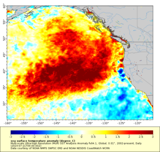
A large area of much warmer-than-normal ocean water off the North America West Coast persistent since 2013-14 and commonly referred to as the "warm blob" has a tendency to correlate to high pressure in the upper atmosphere across the northeast Pacific sometimes "bridging" northward across Alaska to the polar region. The 15-day upper air forecast by the GFS ensemble indicates this pattern emerges for late October. The upper ridge is compensated for by a downstream deep cold upper trough in central North America ("polar vortex").
10/12/2020, 1:58 pm EDT

La Nina Is Intensifying. Peaks As A Strong La Nina in December.

La Nina is strengthening and a robust episode is forecast to peak in December. The first half of 2021 La Nina slowly fades. Primary climate impacts will be developing dryness to drought across the Southern U.S. and a very wet regime in Eastern Australia.
10/11/2020, 8:32 am EDT

Why Strongest Wind Field Was North And West Of Delta At Landfall

When tropical cyclones recurve (turn north and northeast after departing the tropics) they do so by losing their steering currents provided by the subtropical ridge (“Bermuda High”) and increase forward movement (accelerate) if an approaching upper trough is to the west of the storm. These conditions were present Friday evening as Delta went ashore setting the stage for a broad and strong wind (and intense rainfall) field north and west of the storm.