
CIC U.S. Month 1-4 Ahead Climate Forecast
08/26/2026, 5:41 am EDT
Tropical Disturbance EP95 in East Pacific Travels Northward Extended-range; Brings Rain to California
08/31/2026, 8:41 am EDT
Climate Impact Company U.S. Winter 2026-27 Outlook
Wednesday August 26, 2026
Highlight: Stormy El Nino winter West and South; Mild, lack of snow, across North.
Executive summary: The Climate Impact Company INITIAL Winter 2026-27 Outlook is issued. The forecast is based on a constructed analog heavily weighting past strong El Nino events. El Nino 2026-27 has a 70% chance of breaking the record for strongest warm ENSO event on record. The outlook for meteorological winter is excessively warm across the Northern U.S. In this zone, lack of snow cover enhances the anomalous warm regime inspired by persistent marine air from the Pacific extending across the Northern States. The storm track is prohibitive, bringing flooding rains to California coupled with extreme snowfall for mountain areas. The Gulf States to the Mid-Atlantic region are stormy. Severe storms are featured as part of the heavy rainfall pattern (also) causing flooding.
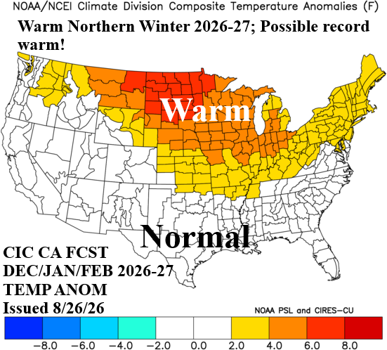
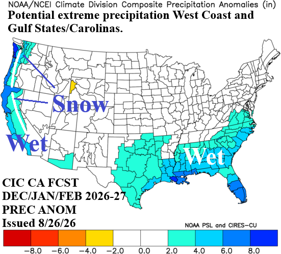
Fig. 1-2: The Climate Impact Company temperature/precipitation anomaly climate forecast for DEC/JAN/FEB 2026-27.
Climate discussion: Categories of climate diagnostics/regimes, their forecasts, and influences on the winter season climate across the U.S. include:
- ENSO: In late August, the conventional Nino34 SSTA index is +27C which exceeds the “Super El Nino” threshold (+2.5C). In 2026, NOAA is now using the relative Nino34 (R-N34) SSTA index to define departure from normal temperature in the Nino SSTA regions. R-N34 removes the warm bias caused global warming of recent decades. R-N34 SSTA index is +1.8C which is just beneath the “Super El Nino” threshold. Currently, all leading dynamic models are forecasting a record strength R-N34 index generating during the last third of 2026. The extreme solution is justified by the presence of record warm upper ocean heat in the equatorial East Pacific Ocean. Dynamic and statistical forecast models indicate “Super El Nino” lasts through meteorological winter 2026-27 followed by a possible sharp decline in intensity next spring. El Nino climate strongly encourages transient Pacific air masses across North America causing mild temperatures and limiting gathering cold air masses.
- AMO/PDO: The North Atlantic basin is the warmest on record during a rapidly developing El Nino episode in August. The daily basin average is +1.00C primarily due to expansive warming of the subtropics, recent warming off the U.S. East Coast and West Africa Coast and intense marine heatwaves (MHW) surrounding Europe. The North America multi-model ensemble (NMME) projects North Atlantic basin to remain much warmer than normal during the winter 2026-27 season except south of Greenland where the North Atlantic warm hole (NAHW) regenerates. The warmer than normal North Atlantic during winter 2026-27 provides a warmer/stormier bias for the North America climate pattern. Meanwhile, the Pacific decadal oscillation index (PDO) is departing a decade-long cool phase and projected to shift to weak positive phase during the winter 2026-27 season. The expected record-strength El Nino is a likely catalyst too (finally) changing the PDO phase. The weak +PDO regime should help to enhance West and South U.S. storm tracks during the winter season and coupled with the warm North Atlantic, enhance the East Coast storm tracks.
- Marine heatwaves: Since 2013-14 when a large marine heat wave (MHW) developed in the Northeast Pacific, MHW’s have become more dominant in mid-latitude SSTA regimes with increasing influence on North America winter climate. Prominent during 2026 are MHW’s off the Southwest Coast of North America and surrounding Europe, each contributing to historic warm temperatures including record summer heat. Each feature will remain although weaker through the 2026-27 winter season. MHW’s in the North Atlantic subtropics stay intense through winter while a MHW northeast of Hawaii now shifts eastward to the West Canada Coast during the winter season. Combined with El Nino, MHW influence on winter 2026-27 favors a mild climate.
- OCN: The steady warming of the mid-latitude oceans during the past 2-3 decades has accelerated during the past 10 years. The warming mid-latitude oceans, driven in part due to increased MHW activity, is affecting climate. Subtropical high pressure ridge areas have tendency to overachieve and when extending across a land mass cause increased risk of drought. Conversely, storms moving across warmer than normal water regions increase heavy rain and flood risk. OCN also biases climate warmer in the middle latitudes especially during the winter season.
- Northern oceans: The northern oceans are generally warmer than normal as the cold season initiates. Colder polar climate creates wind moving across the warm SSTA which can generate early season snow most common across Northeast to North-central Eurasia and Northern Canada. The early season snow cover allows could air mass source regions to develop during early winter poised for release into the middle latitudes given the proper atmospheric pattern. Presence of an El Nino climate during early winter 2026-27 indicates below normal risk of cold air outbreaks.
- Solar activity: Solar cycle progression using sunspot numbers is on the decline in 2026 following the solar maximum during 2024-25. The decline in activity projected for winter 2026-27 is similar with the 2015-16 wintertime El Nino. Interestingly, the polar stratosphere was very cold during DEC-JAN 2015-16 followed by a warming event during FEB-16. Warming of the stratosphere causing ground-level cold is possible but limited to one month during strong to super El Nino winter.
- Snow cover: Due to mild Pacific air inspired by strong to super El Nino, snow cover is limited east of the Continental Divide raising the risk of mild temperatures. The mountainous West can receive a lot of snow biasing the winter season cold, especially the Southwest States to California.
Forecast methodology: The outlooks are inspired by primarily historical patterns associated with strong El Nino episodes. Normally, ENSO and the mid-latitude SSTA regimes which include MHW’s and due to their persistence, the OCN regime, are equally weighed producing the outlooks. However, given the anticipated record breaking El Nino ahead, strong warm ENSO analogs are the primary contributor to the forecast.
November 2026: The November storm track could be ominous and capable of generating cold air in the U.S. rather than cold air delivery from Canada, Mountainous California to the Upper Midwest are snowy. Consequently, snow on the ground helps to generate a large region of colder than normal temperature from the Intermountain West to the Great Plains. Texas is cooler (and wetter) than normal. The Mid-south and Southeast U.S. drought begin to erode. Typical of El Nino climate, the Northeast is somewhat warmer than normal to finish the autumn season.
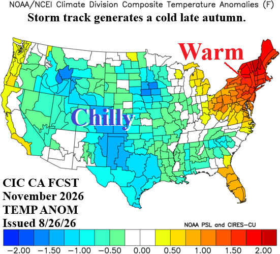
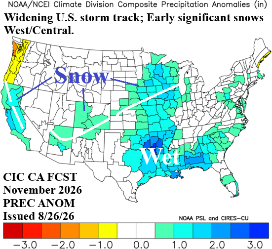
Fig. 3-4: The Climate Impact Company temperature/precipitation anomaly climate forecast for November 2026.
December 2026: The Southern U.S. storm track strengthens and may exhibit extreme precipitation amounts including severe weather in the Mid-south and Gulf States. Possible record warmth is involved with a pattern that can create severe thunderstorm risk in December affecting much of the eastern half of the nation. The Southwest States are chilly due to above normal snow cover. The Coastal Northwest encounters an occasional Pacific storm track.
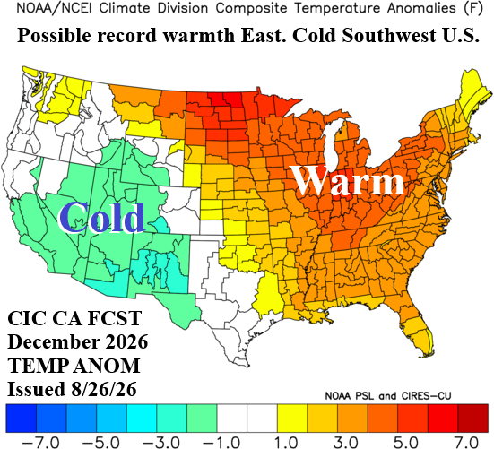
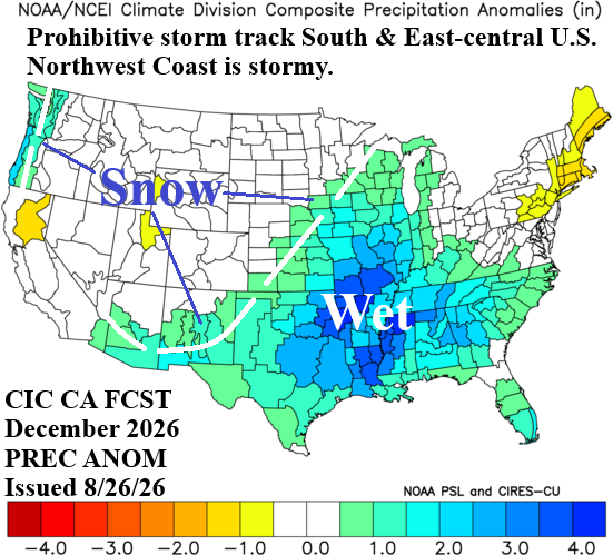
Fig. 5-6: The Climate Impact Company temperature/precipitation anomaly climate forecast for December 2026.
January 2027: After a stormy December, the mid-winter storm track weakens (except on the West Coast while a large drier than normal regime expands across the Tennessee Valley and vicinity. Heavy snow is likely for the mountainous terrain from Washington to California. A warm mid-winter with lack of snow cover continues across the Northern States.
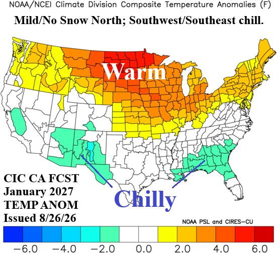
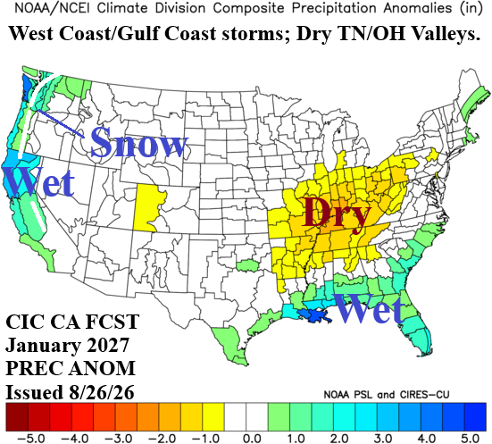
Fig. 7-8: The Climate Impact Company temperature/precipitation anomaly climate forecast for January 2027.
February 2027: The El Nino storm track regains strength during late meteorological winter especially in California where flooding rainfall and extreme mountain snow is likely. The Gulf States and much of the East Coast are also stormy. Dryness lingers across the Western Tennessee Valley. Record warm temperatures inspired by Pacific marine air and no snow on the ground continue across the North in February.
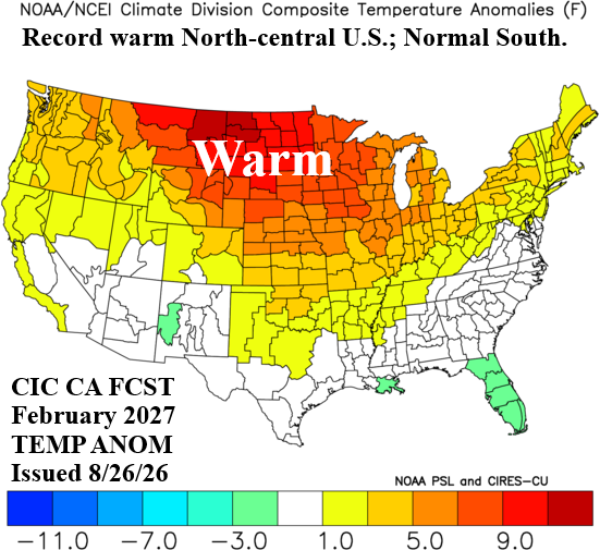
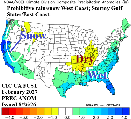
Fig. 9-10: The Climate Impact Company temperature/precipitation anomaly climate forecast for February 2027.
March 2027: Late calendar winter maintains the warm pattern across the Northern States although less dry and possibly some snow. The El Nino storm track continues to roar into California and adheres to the Gulf States. The Southern States are chilly during March.
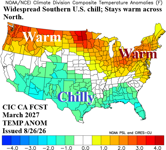
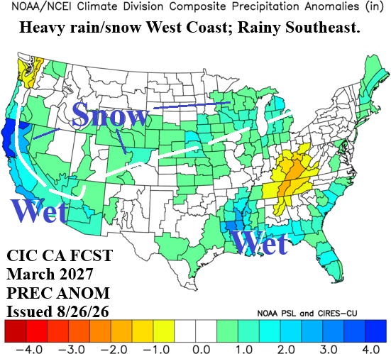
Fig. 11-12: The Climate Impact Company temperature/precipitation anomaly climate forecast for March 2027.