
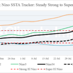
Accelerating El Nino Intensity Slows Down
08/24/2026, 11:48 am EDT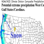
Initial CIC U.S. Winter 2026-27 Outlook
08/27/2026, 10:13 am EDT
Climate Impact Company U.S. Month 1-4 Ahead Outlook
Issued: Wednesday, August 26, 2026
Highlight: More exceptional warmth in September, shift into a stormy El Nino climate begins October. Sneaky cold November; Record warm East December.
Executive summary: The Climate Impact Company month 1-4 ahead outlook is updated. The forecast process is based on persistence (of the current pattern) into October shifting rapidly into an El Nino climate for November/December. Forecast highlights include ongoing very warm risk for the eastern 2/3 of the U.S. during September, an evolving Southern U.S. storm track in October, widening storm track with sneaky cold in November, and possible record warmth in the East during December. El Nino intensification is ongoing and risk of the strongest El Nino on record is near 70% (NOAA) by late autumn/early winter.
Climate discussion: Although an El Nino climate is developing, the influence on U.S. climate so far during late calendar summer is muted by the effects on the upper air pattern of drought across the U.S. and marine heat waves (MHW) off the Southwest Coast of North America and North Atlantic subtropics. Persistence is likely to carry the climate pattern through at least mid-autumn followed by a rapid transition into a Super El Nino climate during November and December.
D0-D4 drought affects 76% of the U.S. which is near historical highs. Large areas of drought across the West and Mid-south U.S. enhance the effectiveness of hot weather producing subtropical ridge areas biasing the overall U.S. climate hot. The semi-persistent location of the upper ridge is to the northeast of the MHW off the Southwest Coast of North America. The southwest quadrant of the U.S. is observing the hottest year on record due to influence on climate of the MHW.
Increasing westerly flow aloft as the summer season fades is pushing the ridge and attendant heat eastward and across the Central and East U.S. to begin meteorological autumn. The drought/ridge dynamic will continue to control the autumn climate into October adding some tropical forcing during September.
NCEP CFS V2 and ECMWF each forecast a vigorous low latitude semi-permanent upper trough for late autumn and through the winter season. The intensity of the trough is likely due to super El Nino.
The constructed analog forecast follows persistence for September and October and the CFS V2/ECM NOV/DEC forecasts.
September 2026 outlook: The persistence dominated CIC-CA forecast for September indicates the late summer hot air mass source region across the new Mid-south U.S. drought area carries the climate through September. Very warm and sometimes hot weather dominates the Central and East U.S. most apparent the first half of the month. Upstream, a compensating upper trough cools the Northwest. The forecast is somewhat different from NOAA which is very warm Northwest and temperate Northeast. Dryness extends across the Gulf States to the Northeast U.S. implying no coastal tropical cyclone risks. The Southwest U.S. monsoon is near to slightly above average wetness but fuels wet weather across the Northern States.
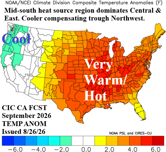
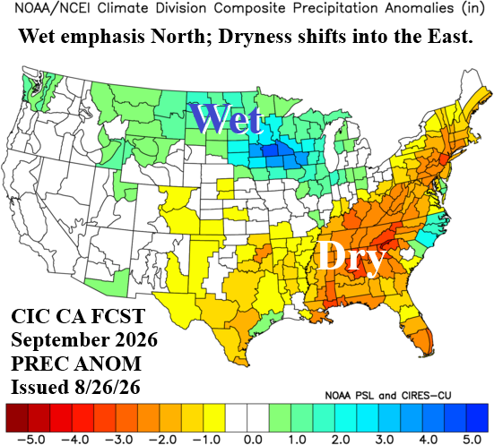
Fig. 1-2: The Climate Impact Company September 2026 temperature and precipitation anomalies forecast.
October 2026 outlook: The mid-autumn forecast is reliant on lingering summertime persistence just prior to a rapid transition into a full-throttle El Nino climate in November. The climate transition could occur earlier. An El Nino-style Southern U.S. storm track is beginning to form. However, anomalous warmth is dominant across the Northwest and Southeast U.S. while a mid-autumn chill is in the air across the northeast quadrant of the U.S.
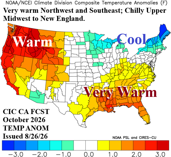
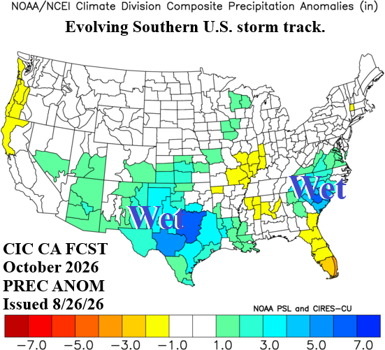
Fig. 3-4: The Climate Impact Company October 2026 temperature and precipitation anomalies forecast.
November 2026 outlook: The November storm track could be ominous and capable of generating cold air in the U.S. rather than cold air delivery from Canada, Mountainous California to the Upper Midwest are snowy. Consequently, snow on the ground helps to generate a large region of colder than normal temperature from the Intermountain West to the Great Plains. Texas is cooler (and wetter) than normal. The Mid-south and Southeast U.S. drought begin to erode. Typical of El Nino climate, the Northeast is somewhat warmer than normal to finish the autumn season.
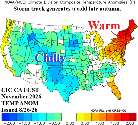
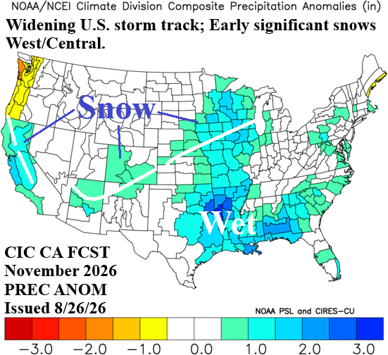
Fig. 5-6: The Climate Impact Company November 2026 temperature and precipitation anomalies forecast.
December 2026 outlook: The Southern U.S. storm track strengthens and may exhibit extreme precipitation amounts including severe weather in the Mid-south and Gulf States. Possible record warmth is involved with a pattern that can create severe thunderstorm risk in December affecting much of the eastern half of the nation. The Southwest States are chilly due to above normal snow cover. The Coastal Northwest encounters an occasional Pacific storm track.
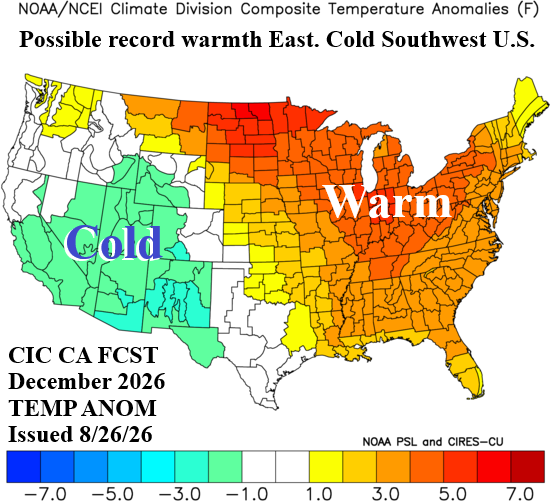
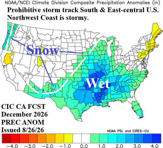
Fig. 7-8: The Climate Impact Company December 2026 temperature and precipitation anomalies forecast.