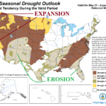
Northern U.S. Drought Expansion/Southern U.S. Drought Erosion (NOAA Outlook) Unfolds in Week 2-4 Forecast
05/22/2026, 10:13 am EDT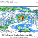
Trade Winds Strengthen Early June Equatorial East-central Pacific Ocean…Not Supportive of El Nino Development
05/26/2026, 8:43 am EDT
![]()
Climate Impact Company Memorial Day Global Weather/Climate Report
Issued: Monday May 25, 2026
Highlight: U.S. D2-D4 drought covers whopping 44.5% of U.S.
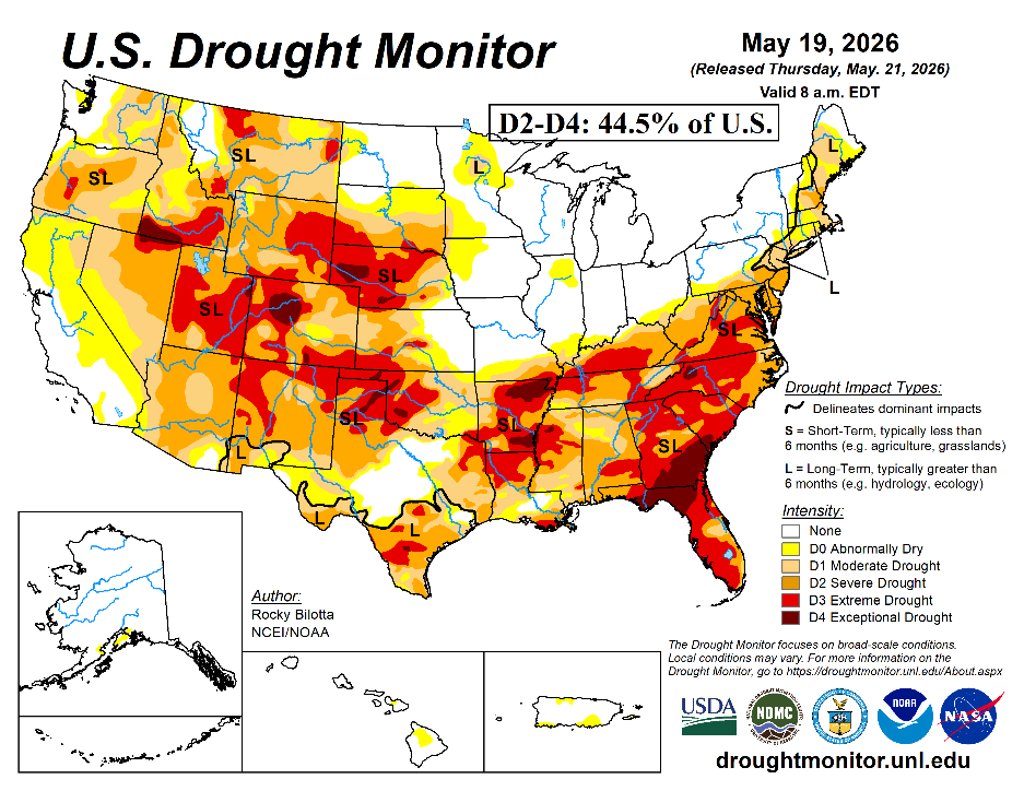
Fig. 1: The U.S. Drought Monitor for May 19, 2026 and the attendant whopping display of D2-D4 severe to extreme drought aerial coverage.
Discussion: The U.S. Drought Monitor reported a whopping 44.5% of the U.S. in D2-D4 (severe to exceptional) drought last Thursday. Hardest hit is the Southeast/Mid-Atlantic States, the Mid-south U.S., and parts of the central and southwest Great Plains plus Interior West (Fig. 1). The aerial coverage of hostile drought conditions is attributed to building dryness of this decade (Fig. 2) propelled by a mostly La Nina-like climate pattern (Fig. 3).
During the past 5 years, driest climate is observed over the Midwest U.S., the Northwest States, parts of the Mid-Atlantic region, and Texas. These regions are (mostly) within harsh drought now and regenerating drought is easier if a drier than normal climate emerges.
The climate catalyst to this dryness is unique. Normally, a long duration La Nina climate coupled with cool phase Pacific decadal oscillation (-PDO) is a drought producer for the U.S. Most of this decade has observed a La Nina climate. However, equally influential on drought creation is -PDO which has been observed almost all this decade. The -PDO is different from all previous lengthy -PDO regimes in that the Northeast Pacific has averaged warmer than normal, not traditionally cooler than normal, but when compared to the robust warmth of the Northwest Pacific, a -PDO regime is calculated. The “new” -PDO emerged as result of a change in the Kuroshio Ocean Current off Japan which widened, strengthened, and extended the attendant warmth across the North Pacific to the east of the Dateline as observed in 2025 (Fig. 4) and common for this decade.
Prior to the new Kuroshio Extension Current, PDO and ENSO were mixed after the 2012 U.S. Drought year (Fig. 5). The result was just the opposite, a wet national climate (Fig. 6).
The daily soil moisture anomalies analysis identifies the widespread ongoing drought regions (Fig. 7). May 2026 soil moisture change is intriguing (Fig. 8). The El Nino climate is emerging as southern latitudes are shifting dramatically wetter and leaving areas to the north in a drier regime. Midwest soils are getting less wet/drier as meteorological summer 2026 approaches.
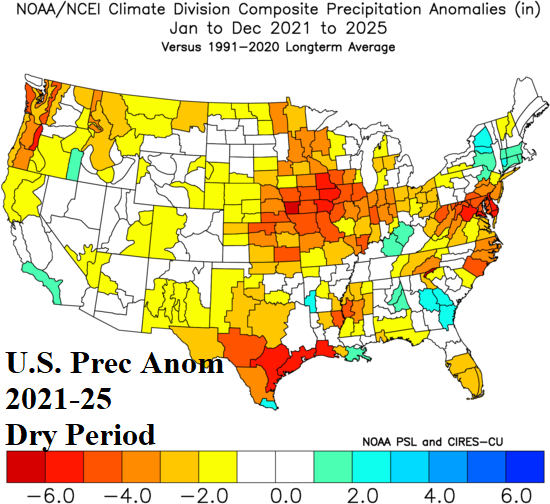
Fig. 2: The U.S. dry period of 2021-25.
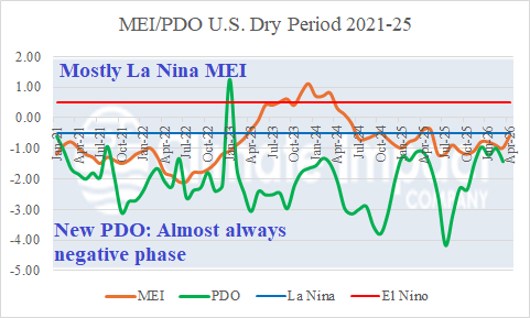
Fig. 3: The 2021-25 ENSO pattern is MOSTLY in La Nina phase while PDO is almost always in cool phase and the likely lead contributor to U.S. dry climate.
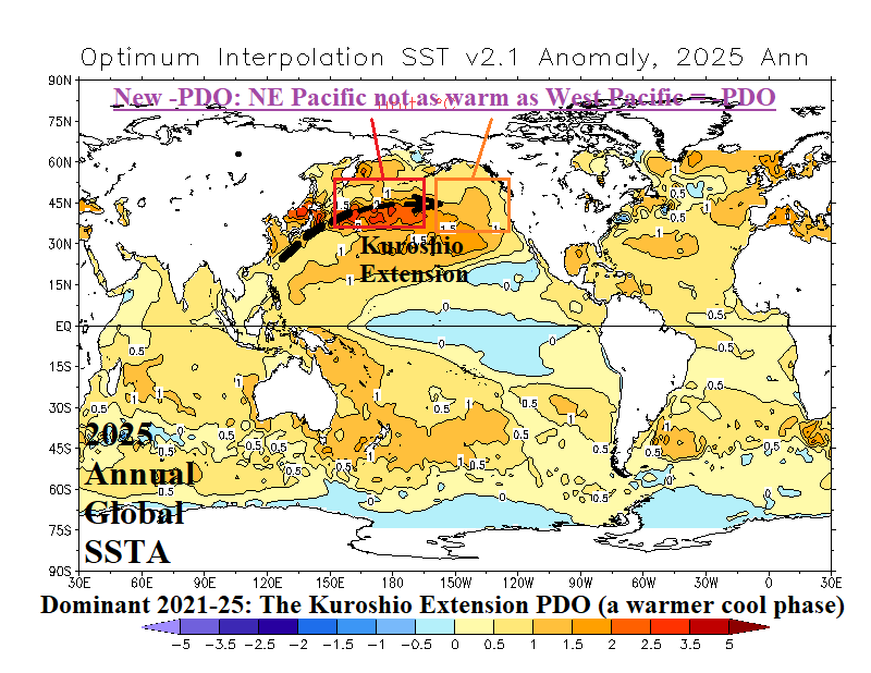
Fig. 4: The 2025 global SSTA analysis reveals a common theme this decade, very warm Northwest Pacific (caused by the Kuroshio Extension) compared with marginally warm Northeast Pacific which produces the “new” -PDO regime.
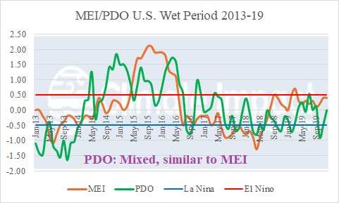
Fig. 5: During 2013-19, PDO ran parallel to ENSO phase and featured a mixed warm and cool regime.
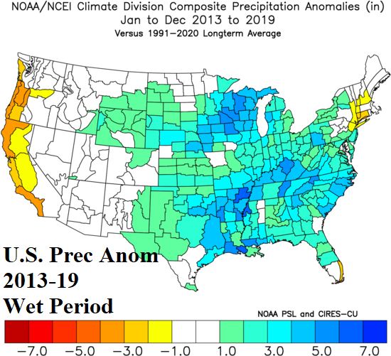
Fig. 6: The U.S. wet period of 2013-19.
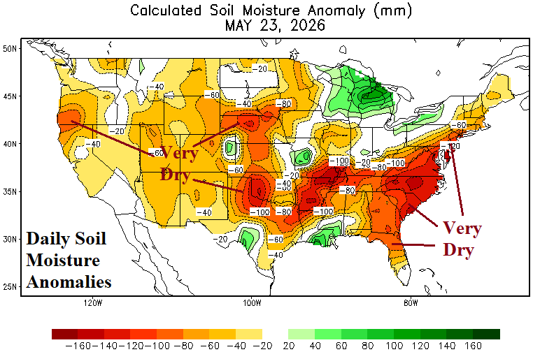
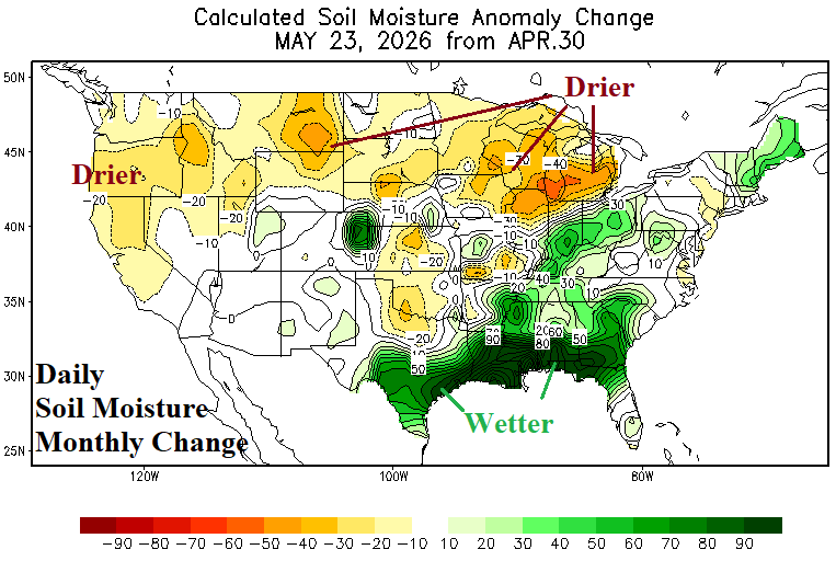
Fig. 7-8: Current U.S. soil moisture anomalies and May 2026 change (so far).