
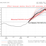
Relative Vs. Historical Nino34 SSTA Forecast for 2026
04/28/2026, 4:40 pm EDT
Models Continue Too Wet Central and Southeast Forecasts Both 16-day AND 16-30-Day
05/03/2026, 3:00 pm EDT
May 2026 Climate Impact Company ENSO Outlook
El Nino onset is just ahead followed by rapid intensity increase for the second half of 2026. El Nino continues well into 2027. IOD forecasts are less certain.
Executive summary: El Nino onset is on our doorstep. Due to the historical upper ocean heat in the equatorial East Pacific which represents potential energy to fuel a significant El Nino, rapid El Nino strengthening is likely through Q3/2026 with a likely peak in intensity which could be the strongest on record occurring during Q4/2026. Uncertain is whether a positive Indian Ocean dipole of significance will develop (or not). El Nino is likely to carry well into 2027 with a possible phase change holding off until Q4/2027 at the earliest.
Climate discussion: The late April upper ocean heat index in the eastern equatorial Pacific Ocean is near +2.2C (Fig. 1). The value rivals the strongest upper ocean heat regime on record observed during the record-strength 1997-98 El Nino. The upper ocean heat represents immense potential energy to force a potential record strength El Nino later in 2026 forecast by some (IMME, UKMO, CMCC), not all, dynamic models. The daily Nino34 SSTA has spiked to +0.93C, a 30-day change of +0.72C. The NOAA weekly Nino34 SSTA was +0.7C. Each value well within the El Nino threshold. However, the most recent new relative Nino34 SSTA is +0.2C. Consequently, the warming required for NOAA to initiate an El Nino onset announcement is likely delayed until either late May or early June.
The Australia Bureau of Meteorology equatorial oceans subsurface temperature anomalies analysis reveals the significant warming in the Central/East-central Pacific at 50-200-meter depth valid for March 29-April 23 (Fig. 2). The NOAA daily anomalies analysis valid April 23rd indicates a +8C observation near 140W at 140 meters (Fig. 3). Each analysis uses a different climatology but identifies the potential energy to fuel a major El Nino in 2026.
In the Indian Ocean equatorial subsurface, notice the warming in the eastern basin subsurface. Some dynamic forecast models (IMME, UKMO, ECMWF) are indicating evolution of a significant positive phase Indian Ocean dipole (+IOD) by JUL/AUG/SEP. The warming in the eastern equatorial Indian Ocean subsurface is required to completely reverse to substantiate the +IOD projection. Consequently, Australia Bureau of Meteorology projects a muted weak +IOD in their 3-6-month outlook while the Climate Impact Company constructed analog projection suggests a stronger +IOD but delayed until SEP/OCT. Usually, +IOD develops with stronger El Nino events.
The issue is important to the Asian Monsoon regime for the 2026 warm season. A strong El Nino climate favors prohibitive dryness across Indonesia westward to India while +IOD would mute the dry signature in India.
Finally, what is the duration of the anticipated strong El Nino episode? Since 1950, the strongest El Nino events have lasted 12-18 months and of the 8 episodes considered, 5 were followed by significant La Nina events, 2 remained in neutral phase, and 1 El Nino returned quickly. The modern-day precedent for strong El Nino events is an ENSO shift to La Nina. El Nino onset in 2026, using relative ENSO index, is likely during June suggesting most of 2027 will stay in El Nino with a possible phase change not initiated until late next year at the earliest.
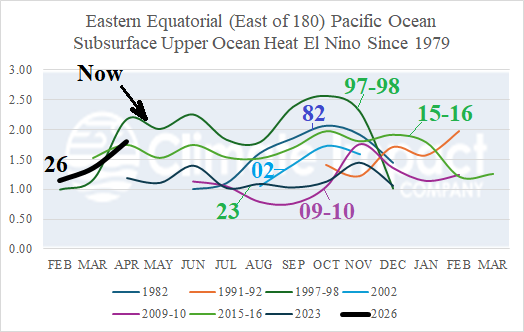
Fig. 1: Current upper ocean heat compared to other strong El Nino events.
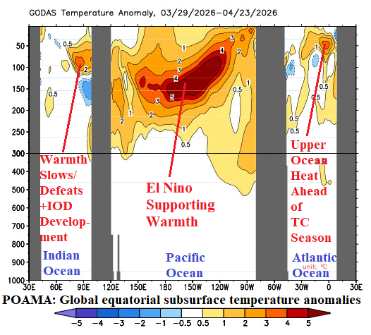
Fig. 2: POAMA global equatorial oceans subsurface temperature anomalies.
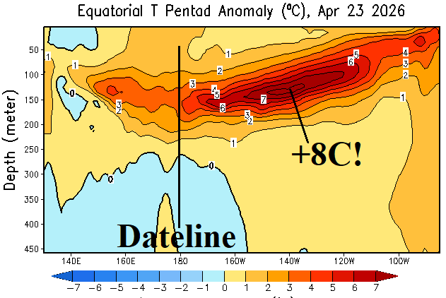
Fig. 3: Current daily NOAA subsurface temperature anomalies across the equatorial Pacific Ocean.