
Tropical Disturbance EP95 in East Pacific Travels Northward Extended-range; Brings Rain to California
08/31/2026, 8:41 am EDT
Climate Impact Company Europe/Western Russia Winter 2026-27 Outlook
Thursday September 3, 2026
Highlight: Mild winter Europe/Western Russia; Best chance of anomalous cold in January.
Executive summary: The Climate Impact Company winter 2026-27 outlook for Europe and Western Russia is milder than normal with record warmth possible in December. The warm SSTA regimes surrounding Europe, across much of the North Atlantic basin, and combined with Super El Nino are the catalyst to the mild outlook. Storm tracks are generally buoyant, most effective across U.K. and West/Northwest Russia. The storm tracks help to weaken the summer 2026 drought. The generally mild winter pattern implies most precipitation is rain with above normal freezing rain events in Western Russia.
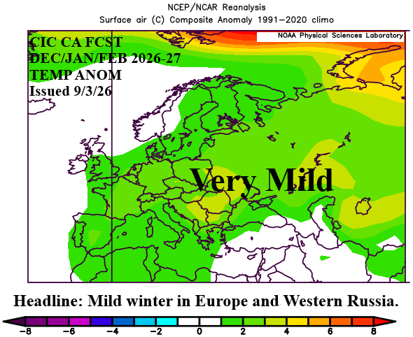
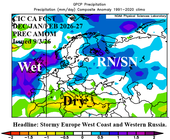
Fig. 1-2: The Climate Impact Company constructed analog winter 2026-27 temperature and precipitation anomalies outlook for Europe and Western Russia.
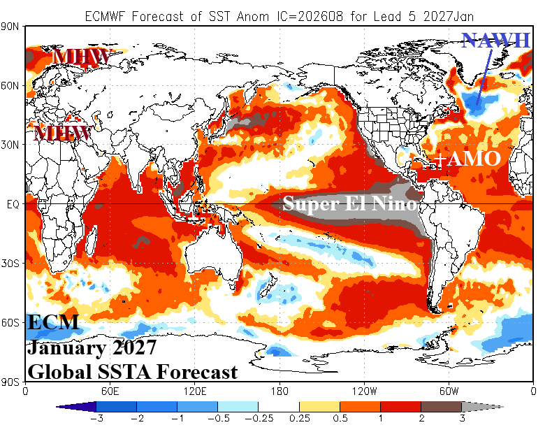
Fig. 3: ECMWF global SSTA forecast for January 2027, and regions of influence used in a constructed analog for Europe/Western Russia winter 2026-27 climate.
Climate discussion: A list of prominent climate forecast parameters, their outlooks and influences follow.
- NAWH: A semi-permanent (2014-26) large pool of cool SSTA south of Greenland is forecast by ECMWF during the winter 2026-27 season (Fig. 3). This feature, present most of 2026 but recently weaker, is expected to regain strength. The North Atlantic warm hole (NAWH) is generated by pooling fresh-water runoff from the Greenland ice sheet-melt during spring. NAWH is (also) linked to the slowdown of the Atlantic meridional over-turning conveyor belt (AMOC) which, at times, has slowed the Gulf Stream progress toward Europe. Aloft, an upper trough is frequently present near the NAWH compensated for by a downstream upper ridge over Europe (Fig. 4). This feature explains the tendency for summer drought and anomalous heat in Europe during the past 10+ years and the mild winter seasons.
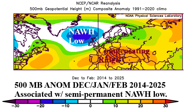
Fig. 4: The meteorological winter upper air pattern associated with NAWH SSTA regime featuring a semi-permanent upper trough southeast of Greenland and the compensating upper ridge over Southern Europe.
- MHW’s: The historic heat and drought across West and Central Europe during summer 2026 is linked to the warmest marine heatwave (MHW) on record in the Mediterranean Sea and off the west/southwest coast of Europe. A semi-permanent MHW is also present in the Norwegian Sea. Each feature is forecast to remain during winter 2026-27 although weaker. Warm SSTA surrounding Europe during winter creates a mild climate bias.
- ENSO: Normally, ENSO influence on Europe winter is weak. However, given the super El Nino forecast for winter 2026-27, most sectors of the globe will be affected. The most recent strong El Nino winter, occurring within the recent uptick in mid-latitude oceanic warming, was 2015-16. Moderate strength El Nino was observed during winter during 2023-24. The 2015-16 El Nino event replicated an enhanced NAWH pattern (above).
- AMO: The accelerated warming of the North Atlantic basin (and global oceans) since 2010 (minus the NAWH pattern) continues in 2026. ECMWF SSTA forecasts for the North Atlantic basin are very warm for the upcoming season The Atlantic multi-decadal oscillation (AMO) should maintain a very warm +1.0 value, a warm influence on Europe winter climate.
- Snow cover: Clearly, the ocean influence on Europe winter ahead climate is warm. However, there is a potential cold caveat. During the 2014-26 NAWH pattern, oceanic warming has also emerged north of the Eurasian continent. Open water is frequently present during the early cold season north of Russia. As the northern latitudes cool, a cold wind across the open water causes an ocean effect snow for Northern Russia frequently associated with above normal snow cover in this region during NOV/DEC of the past decade. Snow cover can force cold air to pool and sometimes last an entire winter season. If early season chill amasses in Russia during NOV/DEC 2026 and the proper upper air flow evolves, cold air can back into Europe (from Russia). This potential scenario is at below normal risk for the upcoming winter season due to enhanced westerly flow aloft caused by Super El Nino.
Forecast methodology: Analog years are chosen based on the regional SSTA influences affecting Europe winter climate identified above. Given heavy influence on the outlook is the 2016-25 optimum climate normal (OCN) and strong El Nino episodes.
November 2026: Meteorological late autumn features a warmer than normal climate across Europe with seasonably cold conditions well to the east in Central Europe. Warmest anomalies are across Southeast Europe. The storm track is impressive and helps to weaken the hostile summer 2026 drought. U.K. to Germany and eastward through Eastern Europe to Central Russia are frequently within the late autumn storm track. Dryness lingers over Italy and Turkey.
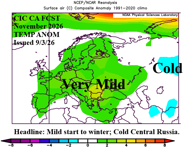
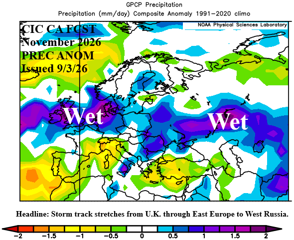
Fig. 5-6: The Climate Impact Company constructed analog November 2026 temperature and precipitation anomalies outlook for Europe and Western Russia.
December 2026: Potentially, a record warm December, forecast across Europe. Warmest anomalies are across Eastern Europe. Additionally, Western Russia is also very mild. Southern Europe is drier than normal during December while the storm track shifts northward most vividly present across Ireland and Northwest Russia.
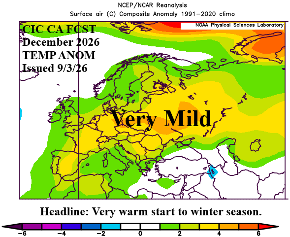
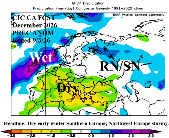
Fig. 7-8: The Climate Impact Company constructed analog December 2026 temperature and precipitation anomalies outlook for Europe and Western Russia.
January 2027: Mid-winter offers cold and snow across Western Russia increasing the risk of cold air masses extending southward through the Black Sea region and westward through Eastern Europe possibly (briefly) reaching Central Europe. Southwest Europe stays mild during mid-winter. The Western Europe storm track remains vigorous while above normal snowfall sustains cold air in Western Russia.
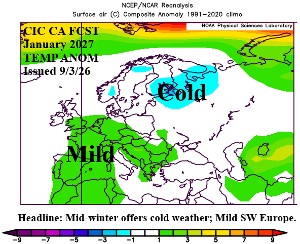
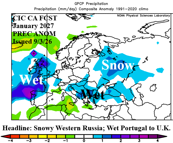
Fig. 9-10: The Climate Impact Company constructed analog January 2027 temperature and precipitation anomalies outlook for Europe and Western Russia.
February 2027: Robust warming returns for late meteorological winter 2026-27. Record warmth is possible across Western Russia. Due to the mild temperatures, most of the precipitation within an active storm track is rainfall. The South-central Europe mountains acquire significant snowfall. Mild temperatures cause mostly rain and/or freezing rain in Western Russia.
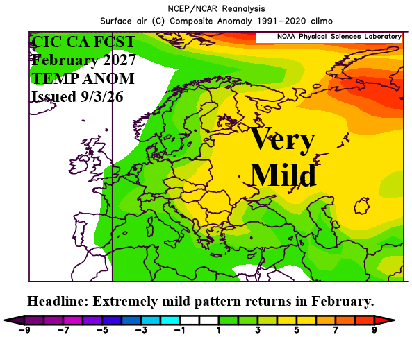
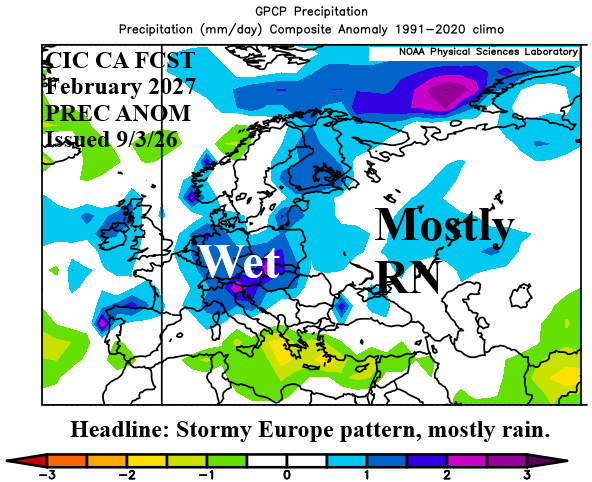
Fig. 11-12: The Climate Impact Company constructed analog February 2027 temperature and precipitation anomalies outlook for Europe and Western Russia.
March 2027: Late calendar winter is chilly across Europe while Western Russia stays milder than normal. The storm track is disorganized although the stormy winter pattern is maintained across U.K.
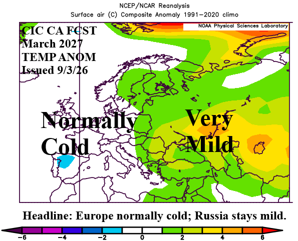
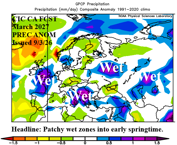
Fig. 13-14: The Climate Impact Company constructed analog March 2027 temperature and precipitation anomalies outlook for Europe and Western Russia.