
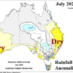
Drought Development/Expansion Underway After a Dry Southwest/East July in Australia
08/04/2026, 5:56 am EDT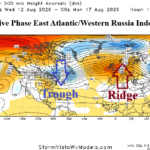
Strong Positive Phase Eastern Atlantic/Western Russia (EAWR) Index Dominates North America/Europe Medium-range Outlook
08/07/2026, 7:01 am EDT
August 2026 Climate Impact Company ENSO Outlook
Issued: Thursday August 6, 2026
Highlight: El Nino strengthening at record pace, strongest El Nino on record likely by Q4/2026, ending time projected for middle of 2027.
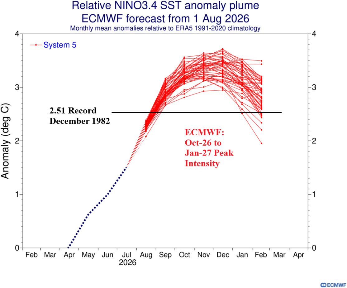
Fig. 1: ECMWF projects a record-strength El Nino 2026-27 peaking during October 2026 to January 2027.
Discussion: Super El Nino is forming. Southern oscillation index (SOI) dipped to -2.68 during July, passing the -2.50 (super) El Nino threshold. Multivariate ENSO index (MEI) lowered to -2.5 during JUN/JUL reaching the super El Nino threshold. The MEI shift from -0.3 during APR/MAY to -2.5 in JUN/JUL ties the strongest negative change on record previously set at the same time of year in 1997 and followed by, at that time, the strongest El Nino on record. The El Nino climate intensity is strengthening at a record pace. The daily standard Nino34 SSTA index increased to +2.52C this week passing the +2.50C threshold therefore qualifying as super El Nino. Relative Nino34 SSTA index is slowly shifting toward -2.0C. The subsurface eastern equatorial Pacific Ocean is record warm and represents additional potential energy for El Nino 2026-27 strengthening. All dynamic forecast models, including ECMWF, are forecasting record strength intensity of El Nino for Q4/2026 (Fig. 1).
Forecast confidence is shifted to above average on record-setting intensity of El Nino 2026-27. However, how long does El Nino 2026-27 last? Based on an analog using both monthly relative operational Nino index (RONI) and multivariate ENSO index (MEI), El Nino ends abruptly during the middle of 2027 and could reverse to La Nina later next year (Fig. 2-3). However, given the uniqueness of the modern-day global ocean temperature (always near or record warm), there is uncertainty of the ENSO regime for after the late 2026/early 2027 El Nino peak intensity.
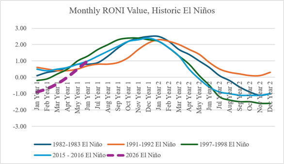
Fig. 2: Based on an analog of strongest El Nino episodes identified using relative operational Nino index, El Nino 2026-27 fades middle of 2027 and could shift into La Nina later next year.
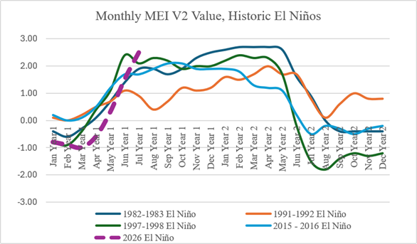
Fig. 3: Based on an analog of strongest El Nino episodes identified using multivariate ENSO index, El Nino 2026-27 fades abruptly middle of 2027.
Based on ECMWF probabilistic precipitation forecasts for SEP/OCT/NOV 2026 and DEC/JAN/FEB 2026-27 significant precipitation regimes will evolve. During SEP/OCT/NOV 2026, expect the Southern U.S., Western Europe, and Southern Europe to shift wetter causing drought conditions to fade (Fig. 4). Wet climate extends from Eastern China across Japan. The wettest probability is centered on Southeast Brazil, where a flooding risk emerges. El Nino inspired dry climate is projected across the northern half of Brazil, much of India, and most of Indonesia.
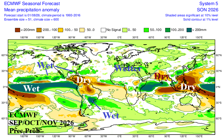
Fig. 4: ECMWF global precipitation probability forecast for SEP/OCT/NOV 2026.
The DEC/JAN/FEB 2026-27 outlook is warmer than normal for northern hemisphere winter except for the Southern United States while the Southeast and East U.S. Coast are stormy (Fig. 5). The U.S. West Coast is stormy. Moderate probability of a wetter than normal winter season is indicated by ECMWF for Europe. Japan endures a stormy winter season. Wet risk is high for Southeast Brazil as flooding rainfall continues. The remainder of Brazil is dry inspiring drought development and intensification. A streak of wet weather emerges from Indonesia to tropical East Africa. Note that both SEP/OCT/NOV 2026 and DEC/JAN/FEB 2026-27 do not indicate prohibitive dry risk across Australia (except the North Coast).
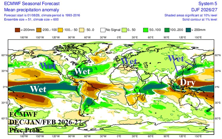
Fig. 5: ECMWF global precipitation probability forecast for DEC/JAN/FEB 2026-27.