

Sharp Regional SSTA Patterns Guide The U.S. Week 2-4 Outlook
07/21/2026, 10:35 am EDT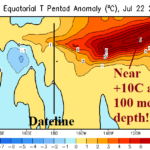
Ahead of Schedule…Evolution of the Strongest El Nino on Record!
07/29/2026, 5:52 am EDT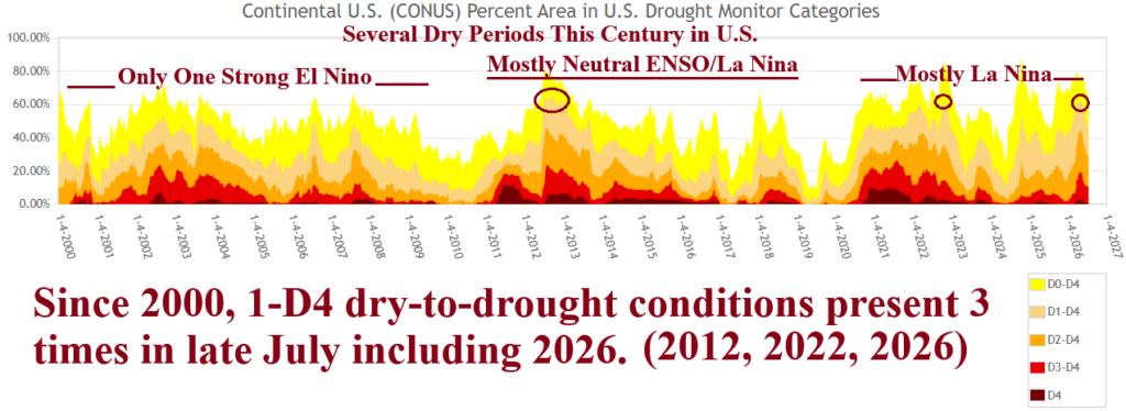


Climate Impact Company Sunday Agriculture Report
Issued: Sunday, July 26, 2026
Highlight: Dangerous heat for U.S. agriculture, longer term forecasts (hot/dry operational and cooler/wetter AI) identify uncertainty. Extreme heat is reborn in Europe.
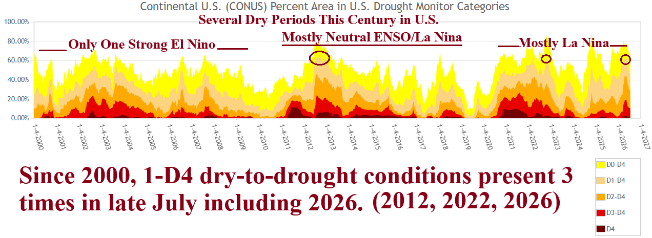
Fig. 1: U.S. soil moisture rankings during this century.
Discussion: Slightly more than 25% of the months of this century have produced an El Nino climate as of mid-2026, about 2/3 the amount observed 1965-95. Consequently, ENSO is a leading contributor to periods of dry climate across the U.S. July 2026 is the 3rd time this century, D1-D4 drought conditions eclipsed 60% of the U.S. (Fig. 1). The core of U.S. drought as mid-2026 is passing stretches across the Interior West to Northwest U.S., parts of the Great Plains (Nebraska and Oklahoma), and the Mid-Atlantic region to Florida (Fig. 2). The developing El Nino will yield drought-defeating precipitation once the cool season is established across the southern half of the U.S. (Fig. 3). While longer term climate forecasts are beneficial, the short-term outlooks for the Great Plains are problematic. Excessive Heat Warnings cover much of the key crop areas from the Upper Midwest to the Mid-south U.S. (Fig. 4). High temperature flirt with 100F and heat index 105-110F in much of the warning area through early week. This type of heat will dry soil rapidly and any rain, which is in short supply during the next 10 days (Fig. 5), will not offer much assistance. The Great Plains temperature forecast is cooler during August with re-emerging heat to follow most vigorously indicated by ECM (Fig. 6). In the extended range (16-30-day) outlook, the same battle is remaining, hot and mostly dry forecasts by ECM, GFS ENS, and CFS V2 compared with cooler and wetter AI models. If drought expansion into the Central U.S. occurs during the next couple weeks due to the mostly hot/dry weather forecasts, following heat for mid-to-late August is (more) easily attained. However, longer range forecast verification has favored AI so far this summer.
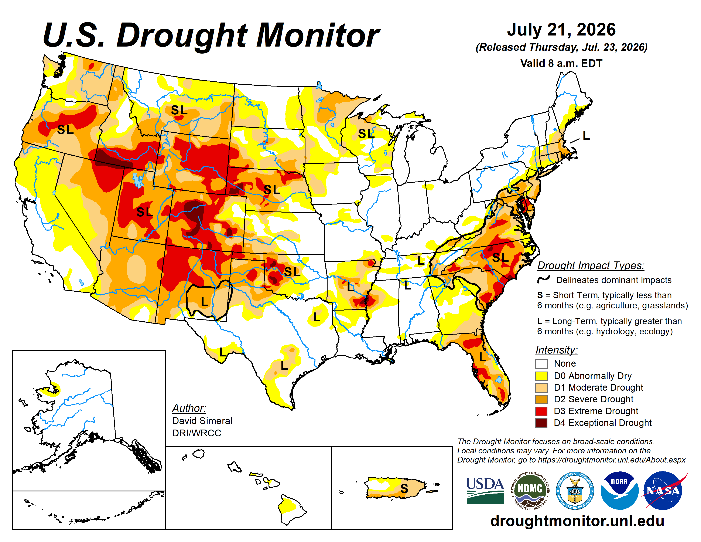
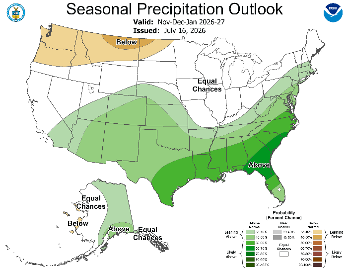
Fig. 2-3: U.S. Drought Monitor analysis and the NOAA/CPC probabilistic precipitation forecast for NOV/DEC/JAN 2026-27.
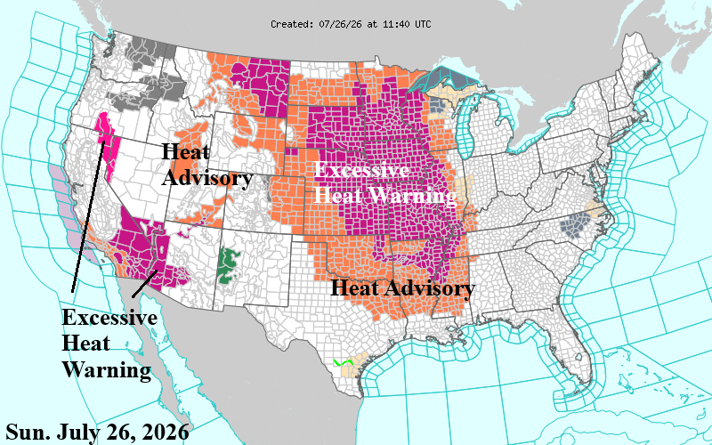
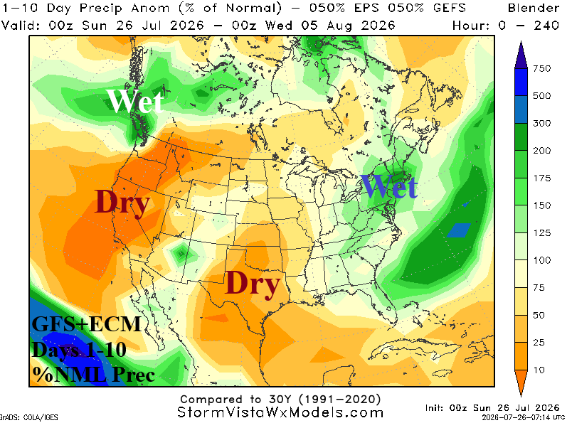
Fig. 4-5: Current U.S. weather watch, warning, and advisory areas plus the GFS+ECM percent normal rainfall outlook for the U.S.
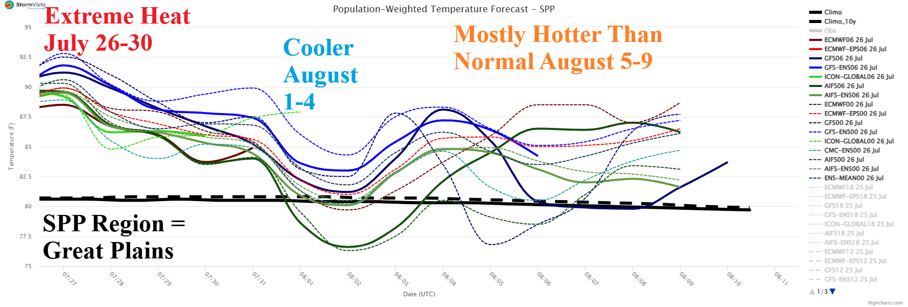
Fig. 6: The Southwest Power Pool electricity region is representative of the Great Plains. Indicated is the population weight daily average 15-day temperature forecast.
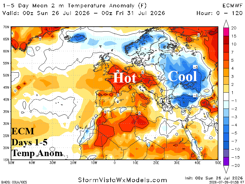
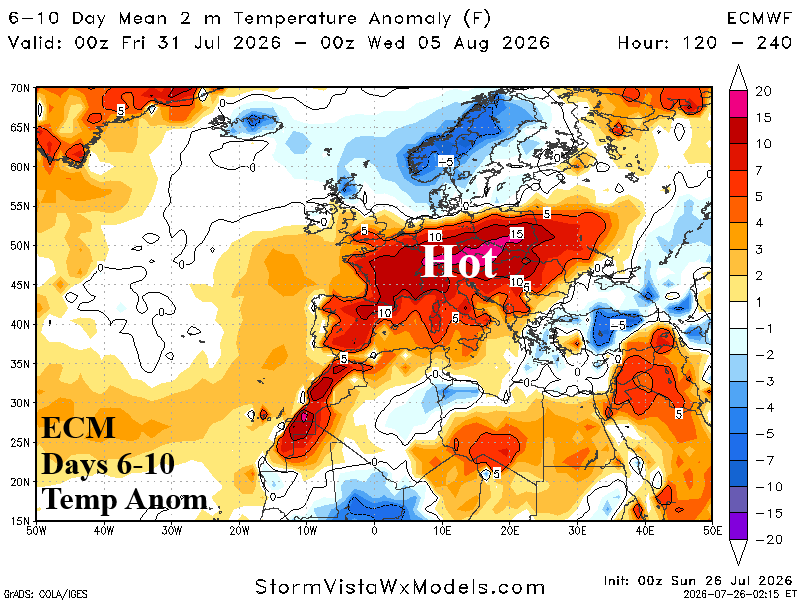
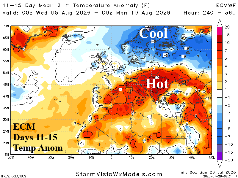
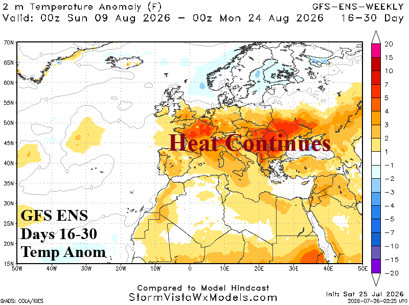
Fig. 7-10: ECM 15-day temperature anomalies forecast across Europe plus the GFS ENS 16-30-day outlook.
In Europe, the next heat wave is developing. The ECM 5-day temperature anomalies forecast identifies the hot weather zone similar with previous heatwaves during the 2026 warm season (Fig. 7). In the 6-10-day period, the heatwave expands and intensifies including parched France and eastward across Poland (Fig. 8). In the 11-15-day forecast, the extreme heat is budging eastward and includes Southeast Europe to the Black Sea region (Fig. 9). In the 11-15-day period, Northern Europe cool weather is expanding southward, possibly into Western Europe. However, the 16-30-day forecast maintains Black Sea heat and returns very hot weather to France (Fig. 10).