
Despite Stronger +PNA/-NAO Forecast, Stratospheric Cooling Over Canada Keeps North America Warm!
10/30/2026, 1:40 pm EDT

Climate Impact Company U.S. Sunday Report
Issued: Sunday, November 1, 2026
Highlight: New CMC and NOAA climate forecasts, stratospheric warming during Super El Nino, and latest HDD forecasts.
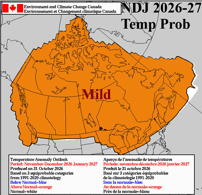
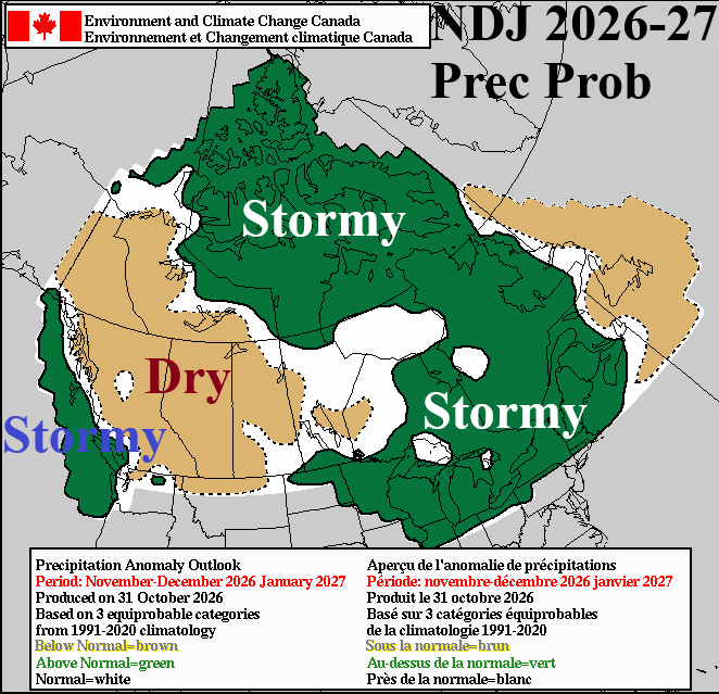
Fig. 1-2: The Canadian Meteorological Center temperature and precipitation probability forecast for NOV/DEC/JAN 2026-27.
Discussion: The Canadian Meteorological Center (CMC) issued a new 90-day seasonal climate forecast yesterday. The outlook indicates warmer-than-normal risk across all of Canada (Fig. 1). Brief cold air masses can occur but ONLY brief. The precipitation outlook favors above normal snowfall across Northern Canada, stormy on the West Coast, drier than on the Canadian Prairies, and above normal rain, snow, and ice Ontario and Quebec (Fig. 2). The CMC precipitation forecast (also) implies above normal amount during NOV/DEC/JAN 2026-27 for the Upper Midwest U.S. and Great Lakes region and wet for the Northwest U.S. Coast.
NOAA/CPC issued a new 30-day outlook valid for November yesterday. The outlook indicates widespread anomalous warmth across the North and East U.S. (Fig. 3) with wet risk suppressing anomalous warmth across the Southwest U.S. to Texas and vicinity (Fig. 4).
Stratospheric warming is occurring on the Eurasian side of the North Pole and forecast to continue through the first half of November (Fig. 5). The event triggers cold air masses over Eastern Russia to Northeast China and Southeast Europe (Fig. 6). Some arctic air is involved with the Eastern Asia episode while snow cover helps to enhance the East Europe/Black Sea cold event. However, largely, this stratospheric warming episode is not sufficiently intense to produce a classic polar vortex split vaulting widespread cold air risk across the mid-latitudes of the northern hemisphere due to (warm) El Nino influence, the anomalous warm oceans north of the tropics, and seasonality.
One month, during wintertime when Super El Nino was present and a stratospheric warming took place was DEC-97. Similar with the current event, the stratospheric warming (Fig. 7) and attendant surface arctic air (Fig. 8) was on the Eurasian side of the North Pole. There was a brief cold surge into the East U.S. during FEB-16 related to a stratospheric warming episode although monthly temperature average for the U.S. during FEB-16 was much above normal
The U.S. gas population weight HDD forecasts are familiar: Warm current and next week with trend toward normal for 2 weeks ahead (Fig. 9). The trend has been once week-2 ahead shifts to next week, a warmer forecast appears.
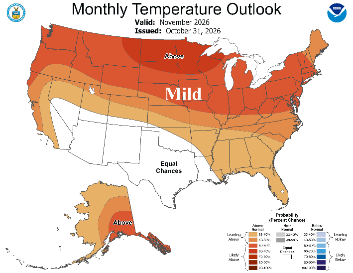
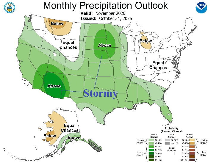
Fig. 3-4: The NOAA/CPC probabilistic temperature and precipitation forecast for November 2026.
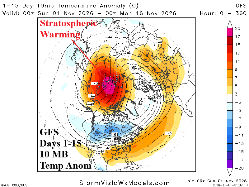
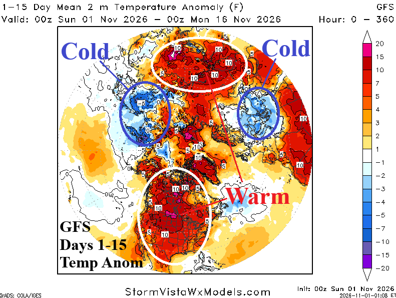
Fig. 5-6: The 15-day GFS 10 MB temperature anomaly forecast identifies stratospheric warming on the Eurasia side of the North Pole and attendant cold air masses over East Asia and Eastern Europe.
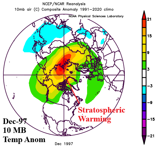
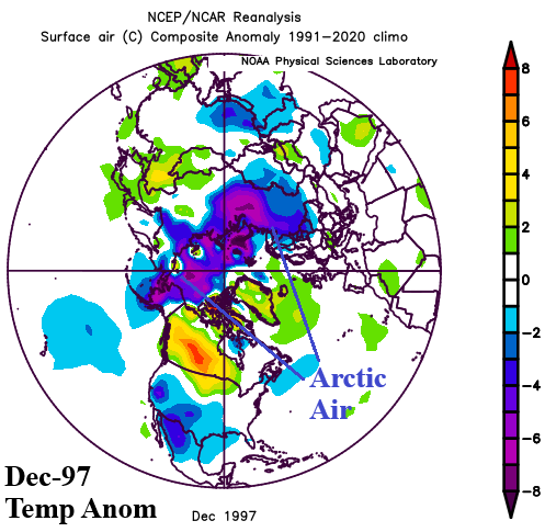
Fig. 7-8: DEC-97 stratospheric warming event during Super El Nino and the attendant arctic air across Eurasia and poleward.
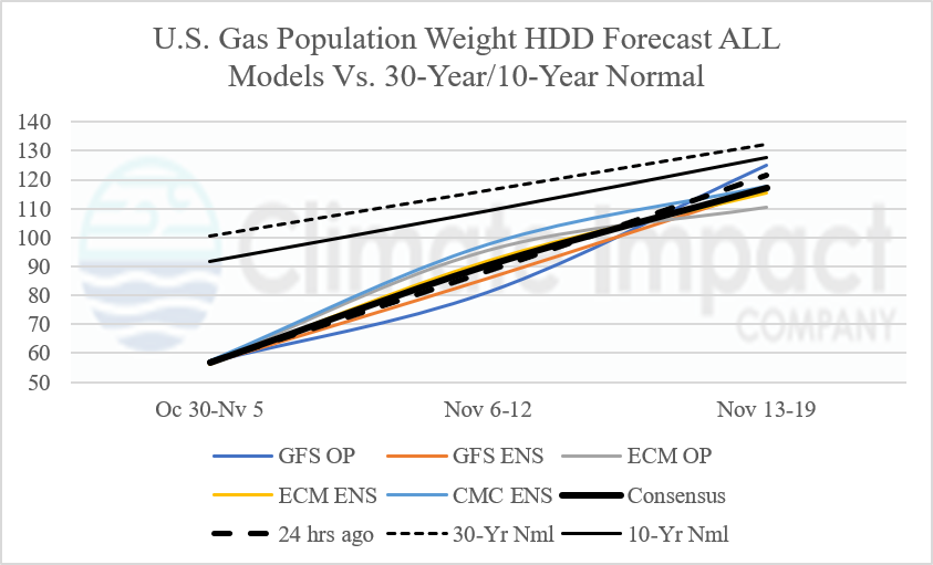
Fig. 9: U.S. gas population weight HDD forecast utilizing all operational models, their consensus, and comparison with 24 hours ago and 30-year/10-year climatology.
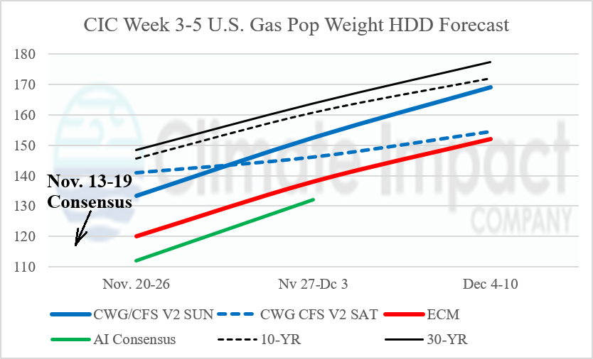
Fig. 10: The U.S. gas population weight HDD forecast for week 3-5 ahead utilizing CWEG analog based CFS V2 projections and CIC estimates based on ECM and AI “weeklies” forecasts.
.