
What Climate Diagnostics Should I Be Watching as Winter Weather Approaches?
10/29/2026, 8:40 am EDT
Climate Impact Company Europe/West Russia Month 1-4 Outlook
Friday October 30, 2026
Highlight: Mild start and finish to meteorological winter but January presents cold risk.
Executive summary: The Climate Impact Company month 1-4 outlook for Europe is updated. The NCEP CFS V2 was utilized to project the November 2026 outlook followed by the Climate Impact Company constructed analog projections for each month of meteorological winter 2026-27. Forecast highlights include diminishing anomalous warmth during late autumn, a mild start and finish to meteorological winter 2026-27 with a cold look to January, especially across snowy Russia. The winter storm track is buoyant and should ease the 2026 drought.
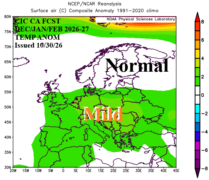
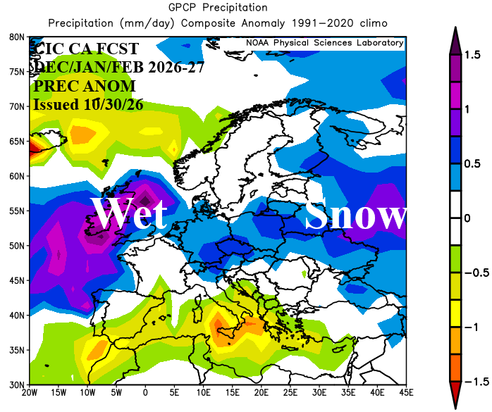
Fig. 1-2: The Climate Impact Company constructed analog DEC/JAN/FEB 2026-27 temperature and precipitation anomalies outlook for Europe and West Russia.
Climate discussion: During October, the prevailing upper air pattern featured a deep upper trough across Greenland and compensating ridge pattern over Northwest Eurasia (Fig. 3). The pattern is reminiscent of positive phase North Atlantic oscillation (+NAO). An upper trough persisted over the Eastern Mediterranean Sea maintain a wet early autumn pattern extending toward the Black Sea region. The attendant cloudiness caused the immense marine heatwave (MHW) across the Mediterranean Sea to weaken substantially (Fig. 4). Finally, the mid-autumn upper air pattern produced a strong subtropical high-pressure ridge across the MHW west of Portugal. Super El Nino continued to strengthen.
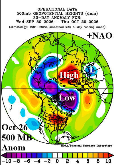
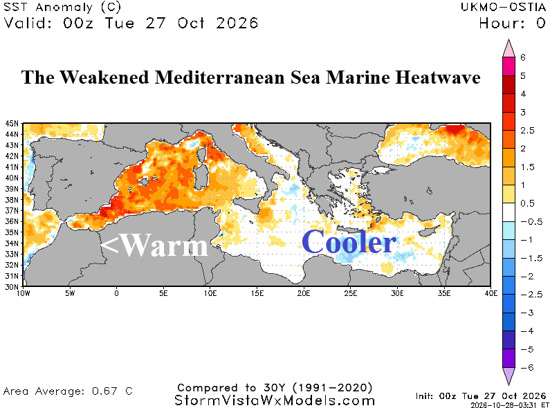
Fig. 3-4: The upper air pattern across the northern hemisphere during October 2026 defined by the 500 MB anomaly pattern and the weakening Mediterranean Sea MHW.
November brings a pattern change as operational models expand the Eastern Mediterranean Sea low pressure area northward to Northwest Russia where a new center evolves and the upper ridge pushes westward in early November gradually eroding the second half of the month. To reflect these changes, the NCEP CFS V2 November 2026 forecast utilized.
November 2026: The NCEP CFS V2 outlook for late meteorological autumn indicates near normal temperature across much of Eastern Europe and Southwest Russia while anomalous warmth shifts to Southwest Europe (Fig. 5). Above normal precipitation is projected for Portugal and the British Islands plus the Black Sea region while dryness prevails across the Central Europe Drought region (Fig. 6). The CIC-CA forecast is very close to NCEP CFS V2.
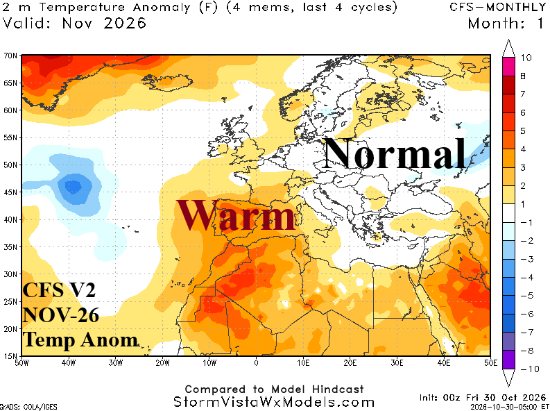
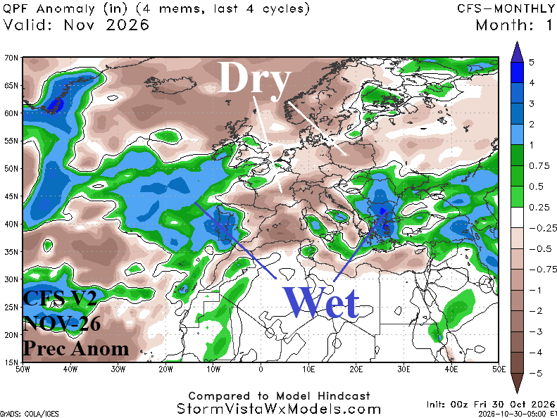
Fig. 5-6: The operational NCEP CFS V2 temperature and precipitation anomaly outlook for November 2026.
The International multi-model ensemble (IMME) global SSTA forecast for DEC/JAN/FEB 2026-27 indicates peaking Super El Nino, an unusually warm North Atlantic (for wintertime) including MHW’s across the Western Mediterranean Sea and most of West Coastal Europe to the Norwegian Sea (Fig. 7). The North Atlantic warm hole (NAWH) is vividly projected by IMME south of Greenland during meteorological winter. The primary guide to the DEC/JAN/FEB 2026-27 constructed analog forecast is the recent (due to oceanic warming) historical relationship of SSTA features identified to the prevailing upper air pattern.
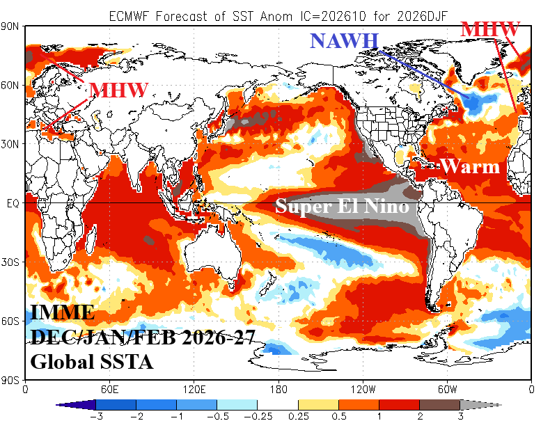
Fig. 7: Global SSTA forecast from the IMME model valid for DEC/JAN/FEB 2026-27.
A leading mode of climate pattern variability across Europe is the North Atlantic oscillation (NAO). Note that most monthly NAO indices from the past 15 winter seasons have featured mostly positive phase which is a warming influence on Europe (winter) climate (Fig. 8). The persistent warm wintertime influence on Europe climate by a +NAO regime is related to the warming middle/northern latitude oceans.
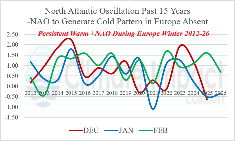
Fig. 8: The monthly North Atlantic oscillation index for meteorological winter 2012-26 indicates mostly positive phase, a warm influence on Europe climate.
December 2026: The CIC-CA projected upper air pattern for early meteorological winter 2026-27 features a buoyant upper ridge across Southwestern Europe downwind from an equally deep upper trough near the NAWH. The sensible weather pattern is warmer than normal across most of Europe with the warm anomaly stretching eastward to Southwest Russia. Although with less intensity (Fig. 9). The precipitation pattern features a dry climate across Southern Europe which is disagreeable with wetter El Nino-influenced dynamic models. The CIC-CA forecast projects an intense storm track extending across the British Islands to Norway in December (Fig. 10).
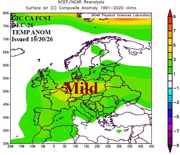
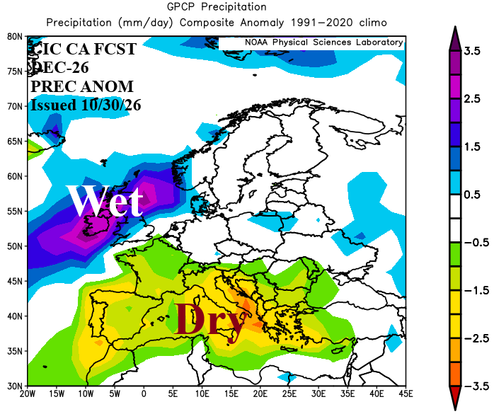
Fig. 9-10: The Climate Impact Company constructed analog December 2026 temperature and precipitation anomalies outlook for Europe and Western Russia.
January 2027: Despite the warmer than normal North Atlantic and Super El Nino, the CIC-CA climate forecast for mid-winter across Europe continues to insist on a cold upper trough across Northwest Eurasia yielding cold and snow across Western Russia at times into Europe (Fig. 11-12). The CIC-CA forecast is remarkably consistent at producing this scary looking scenario. The storm track across West and South Europe is impressive, sometimes featuring snow while Southwest Russia to the Black Sea region and Ukraine is extremely snowy.
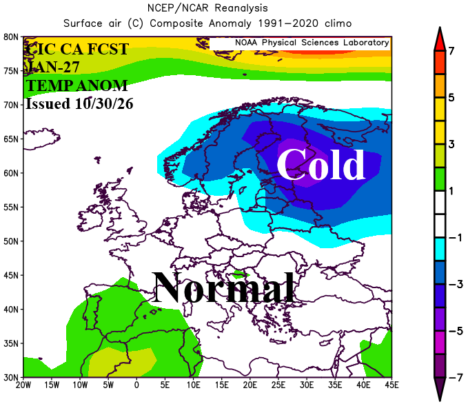
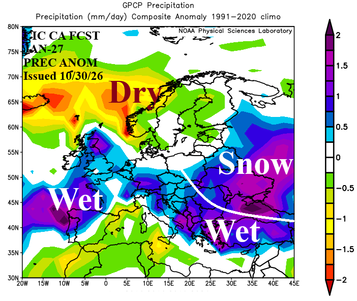
Fig. 11-12: The Climate Impact Company constructed analog January 2027 temperature and precipitation anomalies outlook for Europe and Western Russia.
February 2027: The February outlook flips mild and is stormy across most of Europe and Western Russia (Fig. 13-14). The stormy pattern is very helpful at eroding the 2026 Europe Drought. Most of Europe is rainy although Northwest Eurasia is very snowy to end meteorological winter.
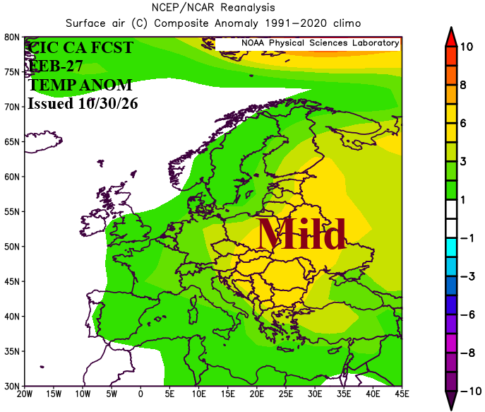
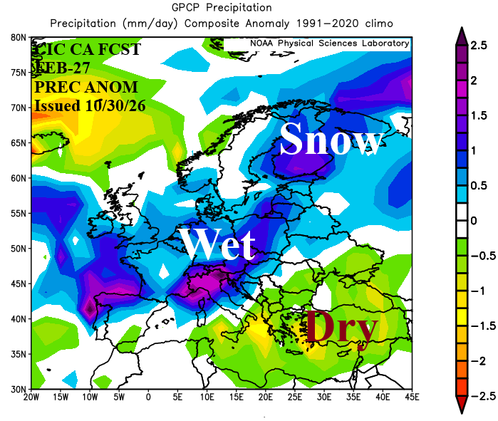
Fig. 13-14: The Climate Impact Company constructed analog February 2027 temperature and precipitation anomalies outlook for Europe and Western Russia.