
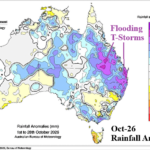
Why is Eastern Australia Soaking Wet During Second Half of October?
10/28/2026, 6:03 am EDT
Climate Impact Company Early U.S. Report
Issued: Thursday October 29, 2026
Highlight: November 1 starts the cold season. What climate diagnostics should I be watching as winter weather approaches?
Admin: Latest Europe month 1-4 ahead forecast out today.
Discussion: Snow cover! Without it, cold risk is very low. Right now, snow cover is well behind schedule in North America certainly reminiscent of last winter (Fig. 1). The Rutgers Snow Lab website is state-of-the-art for following snow cover. Link: NH Snow Cover Extent :: daily monitor
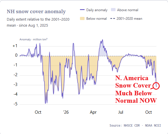
Fig. 1: North America snow cover percent 2001-20 climatology.
Historically, negative North Atlantic oscillation (-NAO) was the key climate signal to cold in the East climate scenarios. Due to the influence of warmer oceans of the past couple decades, -NAO does not guarantee snow and cold in the Northeast/East U.S. A new climate diagnostic, gaining prominence during the “polar vortex” winter of 2013-14 is the East Pacific oscillation (EPO). A strong -EPO climate signal identifies a deep upper trough central continent frequently associated with cold air outbreaks and major winter storms. -NAO is still effective, but -EPO has more (cold air mass) value. EPO 15-day forecasts are flat although moderate -NAO is indicated for early November (Fig. 2). This time, -NAO will chill Eastern Europe/Ukraine but (very) limited influence on the U.S.
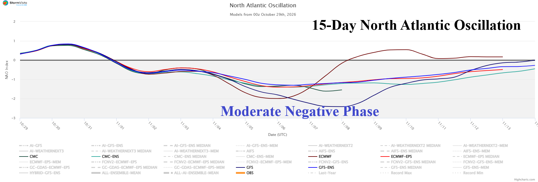
Fig. 2: The 15-day North Atlantic oscillation forecast.
The Madden Julian oscillation (MJO) represents a tropical forcing influence on mid-latitude jet stream patterns that govern our sensible weather. Recently, the MJO activated and shifted eastward to the tropical Indian Ocean where 2-week forecasts indicate intensification (Fig. 3). There are many implications but most interesting is the latent heat release poleward via a Rossby Wave that warms the stratosphere. The dynamic described is common and requires close monitoring during mid-winter when stratospheric warming events are most effective at causing the polar vortex in the troposphere to split and wonder southward to chill the mid-latitudes. MJO has tendency to be less active during El Nino winter.
Finally, stratospheric warming is a popular climate signal generating cold air outbreaks into the mid-latitudes although getting the exact perfect sudden stratospheric warming (SSW) episode to occur is challenging. In the stratosphere, lighter wind and warming is the key diagnostic to monitor for a developing event although knowing the catalyst, such as tropical forcing by MJO, is helpful to validate SSW potential. Stratospheric warming on the Eurasia side of the North Pole is indicated in the medium range (Fig. 4). However, the deep polar vortex trough produced by this event is over the ocean south of Alaska therefore not an effective cold air generator. Upper troughs associated with the stratospheric warming generate chilly air masses in Eastern Europe and Eastern Asia, but the U.S. misses out this time.
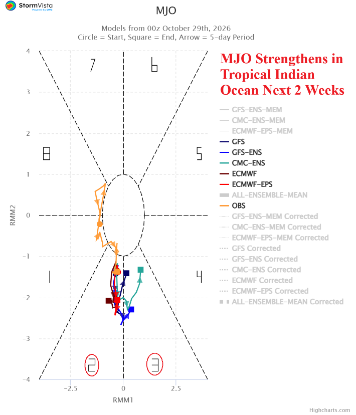
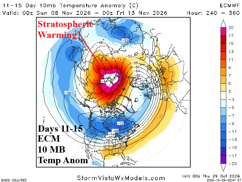
Fig. 3-4: The 2-week Madden Julian oscillation forecast, and 10 MB temperature anomalies forecast by ECMWF for the 11-15-day period across the northern hemisphere.
The U.S. population weight HDD forecast through the first third of November maintains the warm pattern edging warmer than 48 hours ago (Fig. 5). The Canadian Ensemble was chilly for the week of Nov. 6-12 countered by a warm GFS projection at that time.
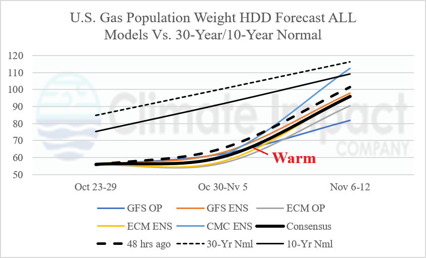
Fig. 5: U.S. gas population weight HDD forecast utilizing all models, their consensus, and comparison with 48 hours ago and 10-year/30-year climatology.