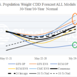
U.S. Daily Energy Report: Leading indicators are -PNA and emerging MJO.
05/19/2026, 10:06 am EDT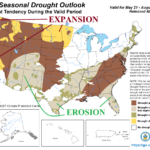
Northern U.S. Drought Expansion/Southern U.S. Drought Erosion (NOAA Outlook) Unfolds in Week 2-4 Forecast
05/22/2026, 10:13 am EDT
Climate Impact Company U.S. Month 1-4 Ahead Outlook
Issued: Wednesday, May 20, 2026
Highlight: Summer 2026 features anomalous heat in the Northwest and Gulf States and (occasionally) adds the Great Plains due to developing dry conditions. Ohio Valley to Northeast States is wet/temperate.
Executive summary: The Climate Impact Company Month 1-4 Ahead Climate Forecast valid for June through September 2026 is updated. The outlook is based on historical regional SSTA patterns including vigorous development of El Nino and ongoing soil moisture conditions similar with expectations for middle 2026 and the correlating upper air pattern generating sensible weather. The outlook is consistent with 5/4 forecast emphasizing anomalous heat in the Northwest and Gulf States, with dryness enhancing heat in the Gulf region, Northwest U.S., and Upper Midwest. The Ohio Valley to Northeast States is wetter than normal suppressing anomalous heat risk.
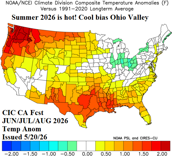
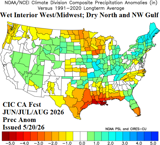
Fig. 1-2: The Climate Impact Company SSTA/soil moisture-based June/July/August 2026 temperature/precipitation anomalies outlook.
Discussion: To EMPHASIZE, as we approach the beginning of meteorological summer, U.S. dry-to-drought conditions are MUCH WORSE than 2012. The current dry soil moisture regime affecting 75% of the U.S. is due to mostly La Nina climate AND marine heatwave influence present most of this decade. The 2012 drought was caused by a lengthy intense La Nina. We mention the long-term climate as triggers to the drought regime due to the drying of deep layer soils which create increased difficulty trying to erode or dissipate drought.
Unlike 2012, the 2026 climate pattern is forecast change, shifting into an El Nino regime the second half of the year. All eyes are on the southern oscillation index (SOI) anticipating sustained negative phase to warrant onset of an El Nino climate. A transition to -SOI has occurred although intensity is choppy. An El Nino climate is developing, but not fully in-place. Once an El Nino climate has developed, Consequently, ongoing regional dry climate enhancing anomalous heat will continue this summer season causing drought to worsen. Full-throttle El Nino-related climate will hold off until later this year bringing the most (wet) benefit to the Southern States.
The updated month 1-4 climate outlooks for the U.S., valid for June to September, are based on diminishing memory of the winter pattern (persistence), evolution of an El Nino climate particularly related to effects on the subtropics (monsoon), and ongoing mid-latitude ocean influences produced (mostly) by marine heatwaves plus, of course, influence of dry (and wet) soil regions on climate. The North Atlantic warm hole (NAWH) also contributes to the prevailing upper air pattern governing North America sensible weather.
To identify the most likely climate influences on North America summer climate, a constructed analog (CA) is developed utilizing past similar SSTA regimes to the JUL/AUG/SEP International Multi-model Ensemble (IMME) global SSTA forecast (Fig. 3) and the projected mid-summer 2026 drought forecast by SPI6 (Fig. 4).
The SSTA forecast indicates a rapidly developing El Nino rivaling the 1982, 1997, and 2015 warm ENSO events for all-time strongest intensity. However, the warm SSTA regimes (also) include a buoyant marine heatwave (MHW) off the Southwest Coast of North America while the Kuroshio Extension (MHW) reaches eastward to the Northwest U.S. Coastline.
The leading concern of the immense warming of the ocean surface in the Southeast Pacific and eastern equatorial Pacific is a potential record intense tropical cyclone season and given the northern reach of warm ocean temperatures allowance of tropical systems to reach California and move inland to the Southwest U.S. with lingering significant intensity. There is concern that East Tropical Pacific systems can move across Southeast Mexico and regenerate in the western Gulf of Mexico. Additionally, the warm oceans are causal to an eventually very wet monsoon in the Southwest U.S.
The thermal gradient between the cooler SSTA in the Gulf of Alaska coupled with the Kuroshio Extension warming off the Northwest U.S. Coast suggests a lingering weak westerly flow aloft preventing a previously forecast super ridge pattern for Southwest Canada.
The IMME North Atlantic SSTA forecast projects a MHW near the Bahamas which supports stronger than normal Bermuda High this summer season. The NAWH pattern south of Greenland is vividly forecast and supports presence of aa semi-permanent low-pressure area near and downwind the cool ocean pool with a compensating upstream high-pressure ridge over Eastern Canada.
Finally, the SPI6 drought forecast for the Central and Southeast U.S. plus Arizona favors hot weather enhancement for those regions peaking during mid-summer. A wet monsoon should eliminate the Arizona hot (climate) bias after July.
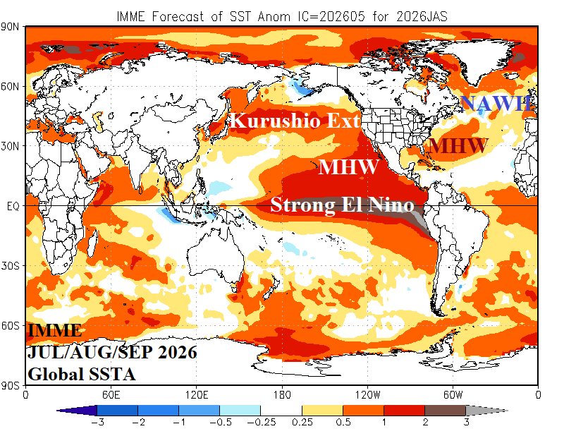
Fig. 3: The IMME global SSTA forecast with annotated regions of significant influence on the summertime climate pattern across North America.
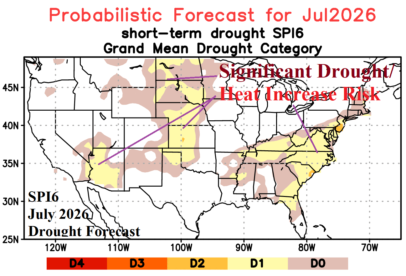
Fig. 4: The SPI6 July 2026 drought forecast for the U.S. which (also) identifies risk areas for over-achieving hot weather.
June 2026 outlook: The CIC-CA forecast for June is consistent indicating anomalous heat and mostly dry climate in the Northwest U.S. with wet risk extending from the Midwest to Northeast States. The Southwest is not as wet as previously forecast while the Upper Midwest trend is drier and the Southeast/Gulf region not quite as dry. The Mid-south U.S. is adjusted hotter. High impact market concerns during June include strengthening Northwest U.S. and Gulf States drought, easing of Northeast U.S. drought, and ongoing Southwest U.S. drought. High impact heat affects California, SPP, and SERC regions.
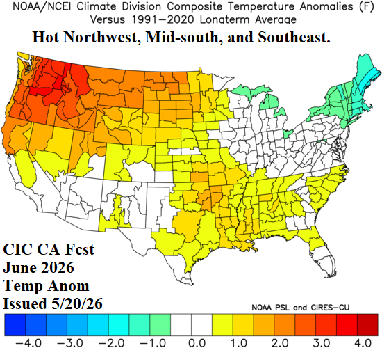
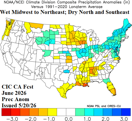
Fig. 5-6: The Climate Impact Company SSTA/soil moisture-based June 2026 temperature/precipitation anomalies outlook.
July 2026 outlook: Great Plains and Southeast U.S. drought are expected during mid-summer. Drought in the Northwest intensifies while the Southwest U.S. drought maintains intensity. Hottest anomalies are across the Northwest and the length of the Gulf States and Mid-south regions. The Interior West is rain-cooled and wet weather extends from Oklahoma to The Ohio Valley and New England. The outlook is generally consistent with the previous projection.
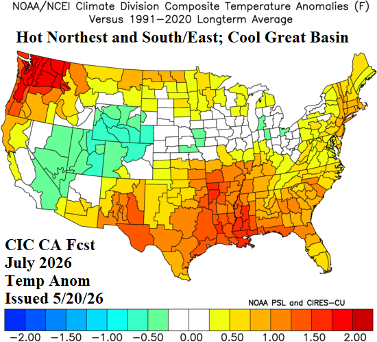
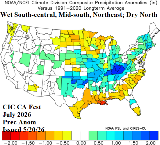
Fig. 7-8: The Climate Impact Company SSTA/soil moisture-based July 2026 temperature/precipitation anomalies outlook.
August 2026 outlook: The Midwest shifts cool while the Central Plains stay dry and drought strengthens. The Northeast reverts to a dry and hot late summer pattern. Texas and vicinity are dry and hot doubting any tropical cyclone influences. The Interior West wet monsoon is stronger than normal. The Southeast States and Florida gain some beneficial rainfall.
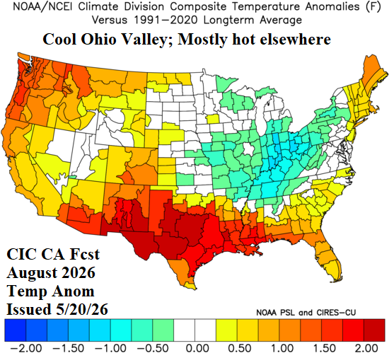
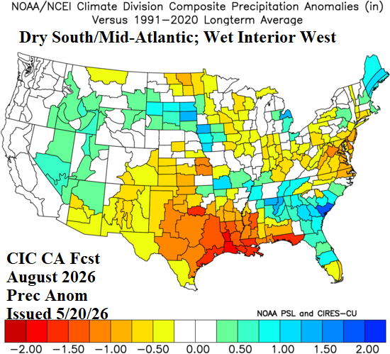
Fig. 9-10: The Climate Impact Company SSTA/soil moisture-based August 2026 temperature/precipitation anomalies outlook.
September 2026 outlook: As meteorological autumn arrives, late summer heat lingers across the Central U.S. to Northeast States. The outlook is similar with previous projection. Dryness is intense in the Mid-south U.S. to the Gulf States and northward to the Midwest. Monsoon moisture brings a very humid month to the Southwest States. New England observes a showery September while the Southeast shifts drier. Implications are no tropical cyclone effects.
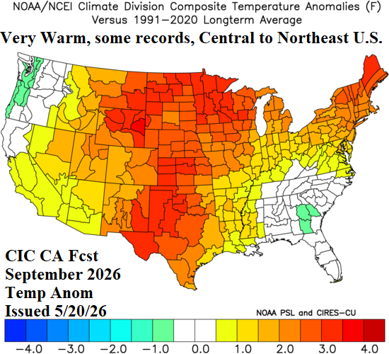
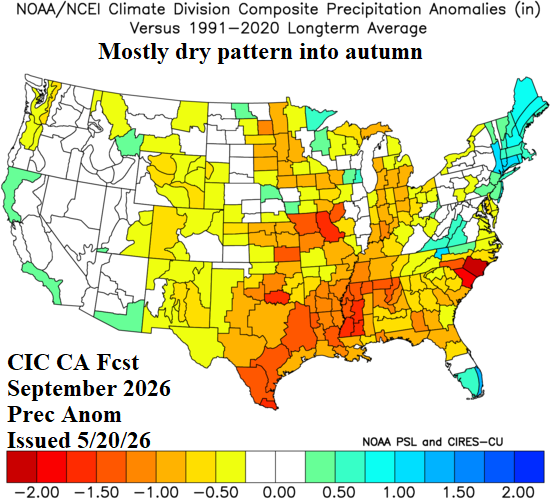
Fig. 11-12: The Climate Impact Company SSTA/soil moisture-based September 2026 temperature/precipitation anomalies outlook.