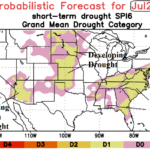
ALERT Great Plains/Southeast U.S. for Drought/Extreme Heat Risk Mid-summer
05/18/2026, 5:50 am EDT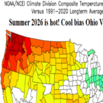
Climate Impact Company Updates The U.S. Summer 2026 Outlook
05/20/2026, 4:00 pm EDT
Climate Impact Company Climate Signals/U.S. CDD Report
Issued: Wednesday May 19, 2026
Highlight: Leading indicators are -PNA and emerging MJO.
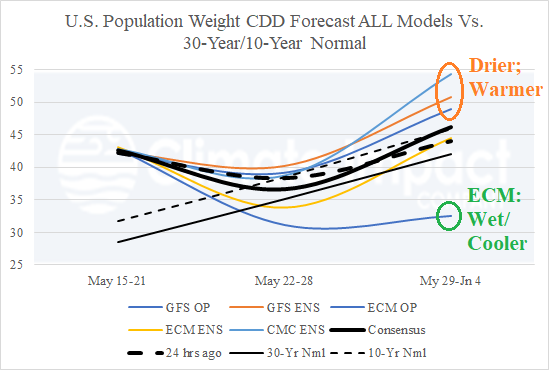
Fig. 1: U.S. population weight CDD forecast utilizing all models, their consensus, and comparing with yesterday and the 10-year/30-year climatology.
CDD discussion: This week’s heat spike in the East and Southeast weighs heavily on national electricity demand (Fig. 1). The national CDD count lowers to near normal next week. The ECM forecast is wetter and suppresses heat risk into early June while other models are less wet allowing some rewarming in the East. In the extended range, 2 of 3 AI models shift much warmer for the week ending June 15th while CFS shifts cooler to near normal (Fig. 2). The AI models shift warmth to the Northeast/East U.S. while other models do not. Forecast confidence is low on this call.
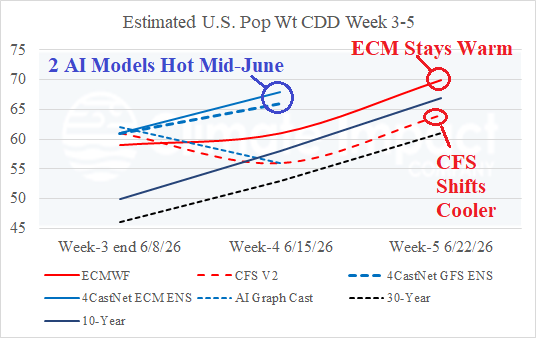
Fig. 2: Climate Impact Company projects U.S. population weight CDD utilizing ECM and CFS V2 plus 3 AI “weeklies” models.
Climate signal discussion: NOAA/CPC forecasts are utilized as a general guide to all users. Model run-to-model run climate signal assessments are reviewed during the day to assess trends. The arctic oscillation is in the positive phase favoring a warm bias to the U.S. pattern (Fig. 3). The North Atlantic oscillation is marginally positive (Fig. 4) favoring (at times) anomalous warmth to the Northeast (in the absence of rain). Most prominent is the negative Pacific North America index favoring a cool trough into the Northwest and warm upper-level ridging east of the Continental Divide (Fig. 5). The ECM ENS 6-10-day upper air forecast demonstrates the influence of -PNA and evolving MJO on the U.S. pattern (Fig. 6). The MJO influence substantially increases wet weather risk across the Southern States while to the north of the convective rains very warm weather emerges in the -PNA pattern. The morning NCEP 15-day MJO forecast continues to increase strength of a system traversing the equatorial Pacific (Fig. 7) enhancing U.S. wet weather events and also linking the warm equatorial East Pacific to the atmosphere to initiate an El Nino climate. Keep in mind, areas with high pressure and attendant sunny skies across a large region of dry soil will overachieve regarding afternoon high temperature potential (Fig. 8).
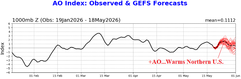
Fig. 3: The NOAA/CPC 15-day arctic oscillation forecast.
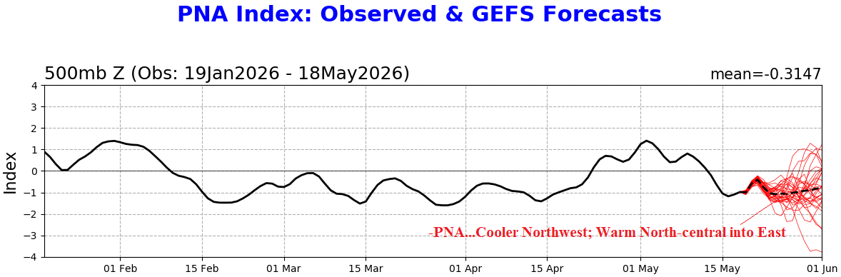
Fig. 4: The NOAA/CPC 15-day Pacific North America index forecast.
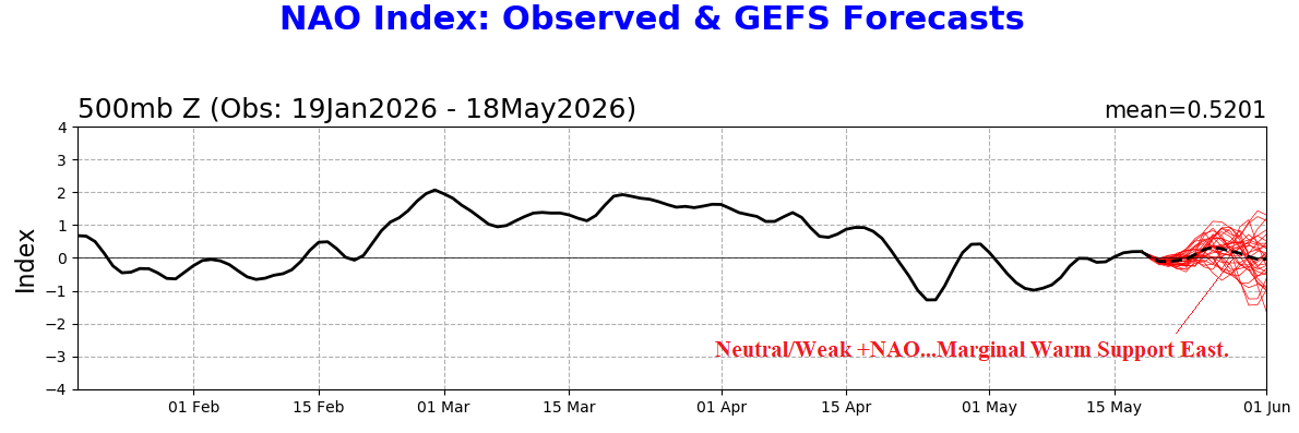
Fig. 5: The NOAA/CPC 15-day North Atlantic oscillation forecast.
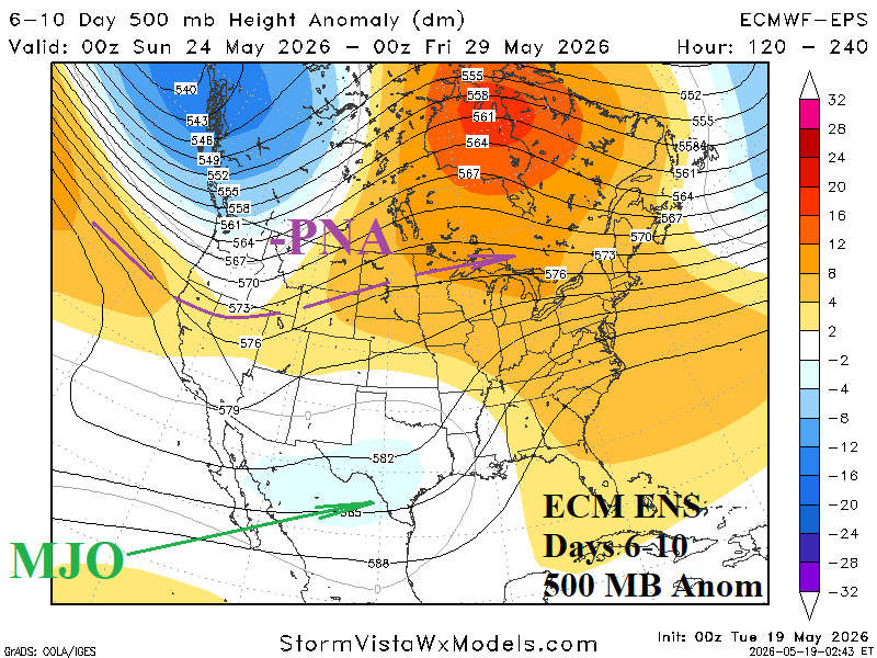
Fig. 6: ECM ENS 6-10-day 500 MB anomaly forecast and influence of primary climate signals.
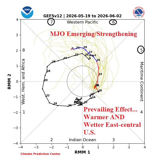
Fig. 7: The NCEP 15-day Madden Julian oscillation forecast.
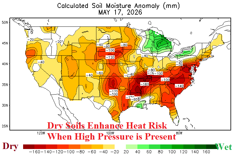
Fig. 8: The NOAA/CPC daily soil moisture anomalies analysis.