The Ongoing Extreme Texas Rainfall
05/05/2024, 8:33 am EDTExceptionally Strong Radar Returns Forecast by HRRR for Severe Weather Next 2 Days
05/07/2024, 8:45 am EDTHighlight: Marine heat wave continues to intensify North Atlantic tropics/subtropics, weather derivatives market accelerating rapidly.
Note 1: According to CME Group, weather derivatives surged by 260% in 2023 against a backdrop of “climate volatility and social shifts”. Accelerated growth anticipated!
Note 2: As mentioned yesterday, Climate Impact Company is taking note of the increased incidence of renegade historical rainfall events in recent weeks including United Arab Emirates, Northern Kazakhstan, Southeast Brazil, Eastern Texas, and Kenya.
Note 3: Updating CDD for selected cities on web this afternoon including ERCOT and PJM. Also adding Europe selected cities.
Note 4: Note the anomalous warmth in the south and southeast North Atlantic basin. That’s at least twice as warm as the previous record warm signature (Fig. 1).
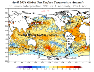
Fig. 1: Global SSTA analysis for April 2024.
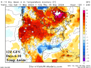
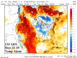
Fig. 2-3: The 12Z GFS medium-range temperature anomaly forecast.
Discussion: On average, Montana to Missouri is adjusted much warmer according to the midday 12Z GFS (Fig. 2-3). The Southeast is cooler in the 11-15-day period.
| CDD EIA End Date | Forecast | 12-Hour Change | 24-Hour Change | 30-Year Normal | 10-Year Normal |
| 5/9 | 30.3 | +0.6 | +0.9 | 18.9 | 20.3 |
| 5/16 | 26.1 | +11.3 | +6.6 | 24.1 | 26.4 |
| 5/23 | 34.4 | +2.3 | -4.1 | 30.3 | 33.5 |
Table 1: The 12Z GFS U.S. population weight CDD forecast compared to 12 and 24 hours ago.