Comparing CFS V2 and ECM 16-30-day Forecast Temperature Bias
05/03/2024, 5:42 am EDTThe Super Warm North Atlantic Tropics/Subtropics
05/06/2024, 1:55 pm EDTHighlight: Update on Texas rains.
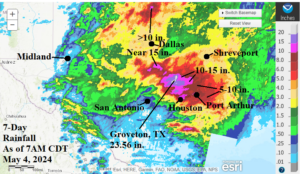
Fig. 1: The 7-day (as of 7AM CDT May 4) rainfall amount observations across the southern Great Plains, Texas, and the Mid-south U.S.
Discussion: An excessive rainfall episode reminiscent of “Harvey” in 2017 steadily emerged over east and north Texas, Oklahoma, and into Louisiana and Arkansas throughout the past week. Rainfall amount in the 10-20 in. range is common in-between Houston and south of Dallas with peak amount (as of dawn yesterday) at Groveton, TX where 23.56 in. of rain was observed (Fig. 1). The culprit is a moist low-level atmosphere southerly flow out of the western Gulf of Mexico northward into air aloft that is cooling rapidly due to the presence of an elongated upper low-pressure trough creating a stationary very unstable air mass triggering wave after wave of torrential rain made worse by severe thunderstorms (Fig. 2). Currently, a Flash Flood Warning (FFW) extends across east-central Texas where life threatening heavy rains are occurring over areas under water due to the extreme rain of recent days. Flood warnings extend southward to Northern Houston and east to the Beaumont area (Fig. 3). The HRRR (model) identifies a squall line causing the FFW soon to be shifting eastward (Fig. 4) followed by another squall line setting up this afternoon and featuring severe thunderstorms from near San Antonion and back into Houston (Fig. 5). The rainfall in the Houston area should abate after tonight. The next chance of excessive rain is in Northeast Texas and Arkansas on Wednesday.
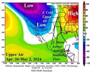
Fig. 2: The late April/early May upper air set-up causing an extreme rain across Eastern Texas and vicinity.
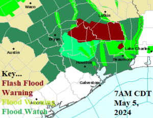
Fig. 3: The Houston NWS Office weather watch, warning, and advisories.
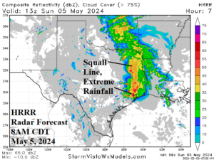
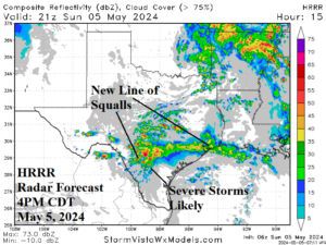
Fig. 4-5: The HRRR (model) radar forecast for Texas NOW and 4PM CDT.