The Super Warm North Atlantic Tropics/Subtropics
05/06/2024, 1:55 pm EDTHigher Than Normal Cooling Degree Day Forecasts for Europe Summer 2024
05/08/2024, 3:17 pm EDT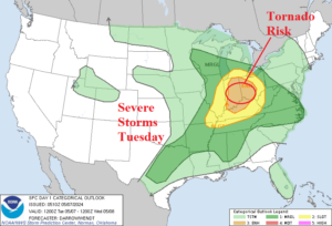
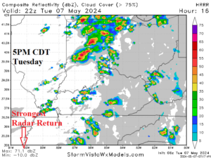
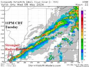
Fig. 1-3: NOAA/SPC severe weather outlook for today and HRRR model and strongest radar return (peak intensity of weather) for today’s event.
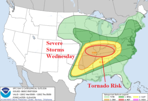
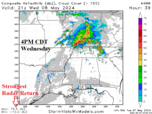
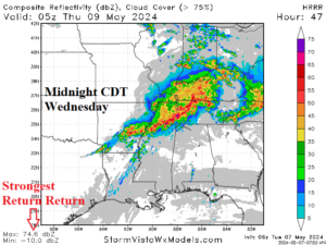
Fig. 4-6: NOAA/SPC severe weather outlook for tomorrow and HRRR model and strongest radar return (peak intensity of weather) for tomorrow’s event.
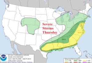
Fig. 7: NOAA/SPC severe weather outlook for Thursday.
Discussion: NOAA/SPC projects a severe weather outbreak centered on the Ohio Valley today and tonight (Fig. 1). Tornado risk is highest in Indiana and Ohio. HRRR projects the strongest radar return of new severe thunderstorms later today at 5PM CDT with widespread streaks of squall lines most potent in Indiana where tornado risk is high (Fig. 2). The squall line shifts eastward at night and maintains intensity with a second intensity peak at 11PM CDT with squall lines stretching from western Tennessee to eastern Ohio (Fig. 3).
On Wednesday, the severe weather (and tornado) risk area is larger and centered on the Tennessee Valley and much of the Mid-south States (Fig. 4). The HRRR model identifies peak intensity of the event at 4PM CDT tomorrow from southern Indiana to western portions of Kentucky (Fig. 5) and again midnight tomorrow focused mostly on Tennessee and Kentucky (Fig. 6).
The severe weather plows into the Gulf States, Southeast, and Mid-Atlantic States on Thursday (Fig. 7).
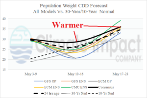
Fig. 8: The U.S. population weight CDD forecast utilizing all models, their consensus, and comparing with 24 hours ago and the 10-year/30-year normal.