
Argentina/Southeast Brazil Trend Wetter Recent Days; More Rain On The Way
10/06/2026, 12:14 pm EDT
Positive Arctic Oscillation = Polar Vortex Evolution
10/08/2026, 10:31 am EDT
Climate Impact Company North Atlantic Basin 10-Day Monitor
Issued: Wednesday October 7, 2026
Highlight: Isaias season’s 9th tropical storm. Will become season’s first hurricane by tonight. The key (to intensification) is warmer than normal Gulf.
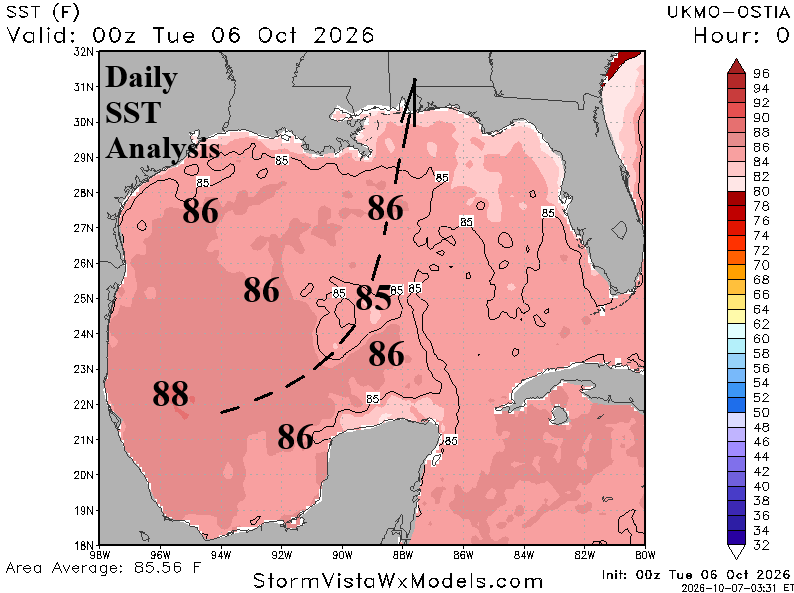
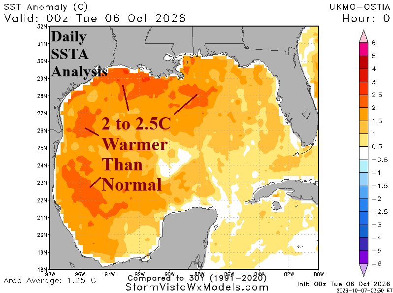
Fig. 1-2: The very warm surface of the Gulf of America.
Discussion: At 5AM EDT, Isaias became the season’s 9th tropical storm. However, this time, Isaias will be able to take advantage of the very warm Gulf of America surface and continue to intensify rapidly into a hurricane by tonight. The NOAA/NHC forecast track takes Isaias across 86F water today which allows rapid intensification (Fig. 1) to a hurricane by tonight. Isaias tracks through a slightly cooler water surface tomorrow returning to near 86F, which is well above normal (Fig. 2), southeast of Louisiana when maximum intensification occurs. Aloft, diffluent flow is immense today, encouraging a “chimney effect” that allows rapid intensification. However, upper shear is strong near the Gulf Coast and could cause Isaias to weaken approaching the Gulf Coast near Mobile, AL Friday evening.
Tropical cyclone models are in general agreement on the east-northeast track through the next 2 days but vary on when Isaias turns north-northeastward which makes a large difference on landfall ranging from anywhere just east of New Orleans, LA to near Panama City, FL (Fig. 3). Normally, given the SST, a major hurricane would emerge. However, proximity to strong shear on the Gulf Coast makes the intensity forecast challenging. Tropical cyclone models indicate a 40% chance of category-2 hurricane, and 10% chance of a major hurricane in the Northern Gulf in 54-60 hours (Fig. 4).
Isaias will produce an immense amount of rain on the central/northeast Gulf Coast extending well inland and northeastward to the Carolinas according to the NBM forecast through Sunday night (Fig. 5). Hurricane force wind should be anticipated in far Southeast/East Louisiana to the West Florida Panhandle. The NOAA/NHC forecast track identifies the rapid intensification to a hurricane by tonight and potentially, a major hurricane tomorrow night south-southeast of Louisiana (Fig. 6).
At 5AM EDT, Tropical Storm Isaias was located at 22.0N/94.1W or about 580 miles southwest of the Mississippi River with maximum sustained wind near 40 mph moving east-northeast at 8 mph and central pressure 1004 MB.
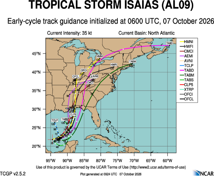
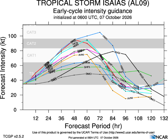
Fig. 3-4: Tropical cyclone model tracks and intensity forecast for Tropical Storm Isaias.
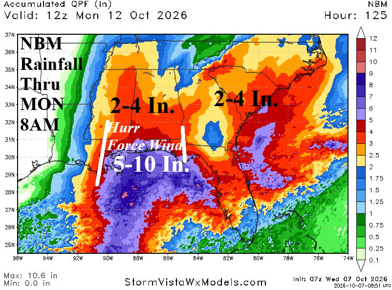
Fig. 5: NBM rainfall amount forecast through Sunday night.
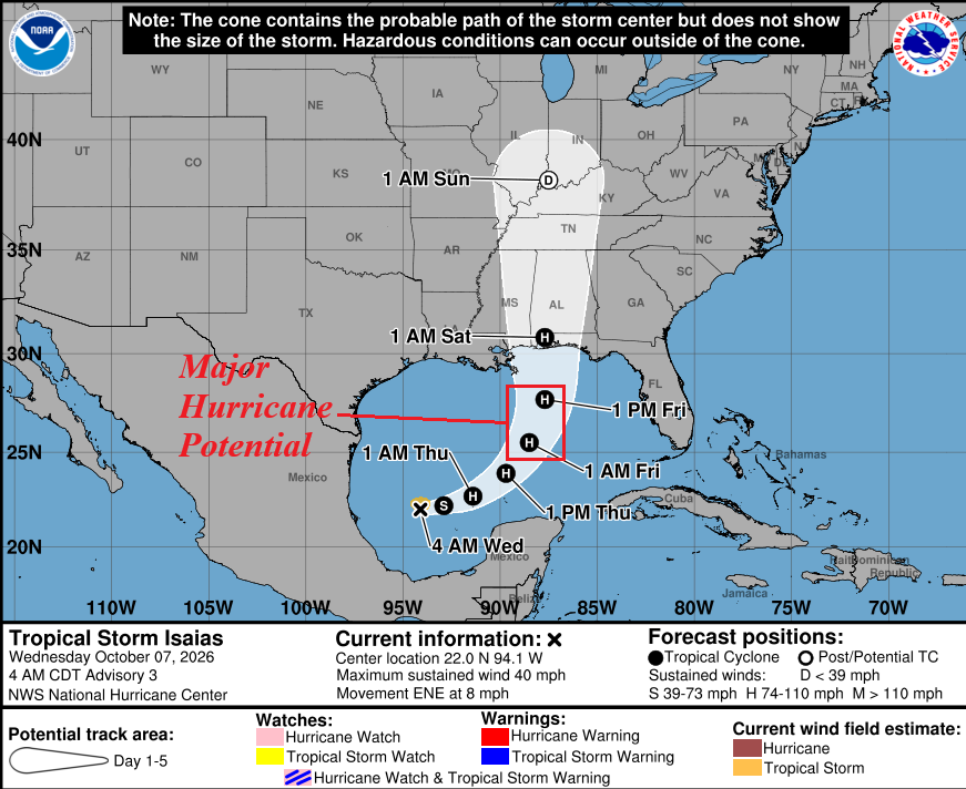
Fig. 6: NOAA/NHC forecast track and intensity for Tropical Storm Isaias.