Focus On U.S. Corn Belt Drought
06/18/2023, 5:48 pm EDTEmerging Marine Heat Wave Leads to “Highest Heat Warning Possible” in Beijing
06/23/2023, 8:56 am EDT
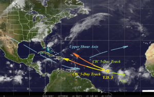
Fig. 1: Satellite view of the North Atlantic basin.
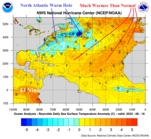
Today’s discussion: Tropical cyclone formation in the central North Atlantic tropics during June is unusual. The catalyst this year is a favorable low shear environment and enhanced early season inter-tropical-convergence-zone (ITCZ) enables by much warmer than normal SSTA. Forecast confidence is LOW for both Tropical Depression 3 and Tropical Disturbance 93L. Climate Impact Company indicates 5-day tracks toward the west and west-northwest with strengthening to tropical storm strength expected (Fig. 1). NOAA/NHC is farther west and stronger (hurricane) with TD 3 into the eastern Caribbean Sea in 5 days. 93L is forecast to turn north of the Northeast Caribbean Sea in 5+ days. The mid-troposphere relative humidity (RH) anomalies are very dry across the Gulf of Mexico and Caribbean Sea helped by axis of the upper shear axis (Fig. 2). For the moment, conditions in these 2 regions are not supportive of tropical cyclone activity. In the Bahamas to central North Atlantic tropics, conditions are more supportive of development. NOAA/NHC projects TD 3 becoming a hurricane into the eastern Caribbean Sea in 4-5 days. Climate Impact Company is weaker with TD 3 due to an environment that is less favorable compared to the NOAA/NHC projection. As previously stated, forecast confidence is low! The North Atlantic SSTA analysis reveals dramatic regimes from the unusually warm tropical/subtropical signature to the North Atlantic warm hole (NAWH) off the East Coast (Fig. 3).

Fig. 2: Mid-troposphere relative humidity anomalies for June 15-17, 2023.

Fig. 3: The North Atlantic Basin sea surface temperature anomalies for June 16, 2023.
