
Freeze Risk Southern Brazil Days 11-15 On The Table
06/10/2025, 10:51 am EDT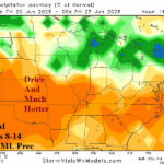
U.S. AG Belt Turning Drier/Hotter Days 8-14 Ahead
06/13/2025, 5:15 am EDT![]()
June 2025 Climate Impact Company ENSO/IOD 2-Year Analog Forecast Through May 2027
Issued: Wednesday June 11, 2025
Highlight: Constructed analog and dynamic models agreeable to neutral ENSO, cool PDO, and warm AMO ahead while disagreeable on the IOD projection.
Executive summary: Climate Impact Company reviews the current ENSO, PDO, AMO, and IOD regimes and utilizes a constructed analog to project the most likely phase of each climate signal through May 2027. ENSO remains uncertain as neutral phase continues and whether a flip to El Nino or La Nina occurs later this year or next year is a mystery. Based on history, an ENSO regime similar with the past 2 years, is most likely to favor neutral ENSO through May 2027 and quite certain to avoid any strong El Nino or La Nina surprises. The longest duration -PDO on record will continue through next year. The +AMO regime of the past decade (also) continues. The character of the -PDO and +AMO regimes supports increased risk of subtropical high pressure ridging and a warmer climate plus increased risk of stronger storms when low pressure crosses over anomalous warm water due to higher evaporation rates. The IOD constructed analog forecast is neutral phase. However, ECMWF disagrees and project a strong negative phase later this year inspiring heavy rains for Southeast Asia and Australia. Of note, long-term cycles of ENSO/PDO/AMO historically last 2-3 decades. The current cool ENSO/PDO and warm AMO cycle is 3 decades old. Is there a cycle change ahead during the second half of this decade?
Discussion: The Nino34 SSTA constructed analog forecast through May 2027 reveals a substantial change from last month. The potential for weak El Nino later this year is erased, and neutral ENSO is preferred into 2026 (Fig. 1). 2 of the 4 analogs favor a weak La Nina risk for later this year. Neutral ENSO is likely for the 2025 North Atlantic hurricane season. Next year, the constructed analog forecast is similar with the previous outlook favoring continued neutral phase with potential for weak La Nina.
Earlier this decade, some climate scientists dismissed the relevance of Pacific decadal oscillation (PDO) and Atlantic multi-decadal oscillation (AMO) stating the dynamic evolution of warm and cool phase of each climate signal cannot be consistently explained. Climate Impact Company disagrees with this premise. The presence of the warm or cool phase certainly affects climate and can enhance ENSO effects.
The PDO constructed analog maintains the negative phase present this entire decade (Fig. 2). The negative phase extends through next year possibly weakening to neutral phase in 2027. Usually, -PDO presence favors La Nina potential. The -PDO of this decade is different from previous -PDO regimes in that waters off the U.S. West Coast are near normal but a short distance westward warm significantly across the remainder of the mid-latitude Pacific. Previously, the warming was in the West Pacific while the East Pacific was cool during -PDO regimes. The current -PDO regime is the longest on record.
The AMO pattern has been historically warmer than normal for the past 10 years and record warm last year (Fig. 3). The anomalous warmth is unique to the past decade therefore analog years prior to 2015 are not available. Recently, the AMO index cooled to moderate warm intensity. Some additional warming is expected through the next 3-6 months as the strong warm phase continues. The +AMO regime increases the risk of high pressure ridging when extending over North America and Europe causes warmer than normal climate. +AMO also raises the amount of moisture in the lower atmosphere for increased evaporation for passing storms making them stronger. +AMO also increases the risk of stronger and more plentiful tropical cyclones.
The IOD pattern is neutral and forecast to remain this year based on the constructed analog (Fig. 4). There is risk of -IOD in 2026. Dynamic models disagree. The ECMWF global SSTA forecast for November 2025 is agreeable with the constructed analog projections of neutral ENSO, -PDO, and +AMO. However, the IOD projection is moderate-to-strong negative phase (Fig. 5). Emergence of -IOD will bias the Southeast Asia and Australia climate wetter than normal and could also cause an atmospheric condition favorable for La Nina development in the eastern equatorial Pacific Ocean.
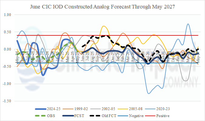
Fig. 1: The Climate Impact Company Nino34 analog forecast to determine oceanic ENSO phase through May 2027.
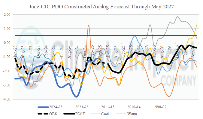
Fig. 2: The Climate Impact Company Pacific decadal oscillation analog forecast through May 2027.

Fig. 3: The Climate Impact Company Atlantic multi-decadal oscillation persistent warming of the past 10 years.

Fig. 4: The Climate Impact Company Indian Ocean dipole analog forecast through May 2027.

Fig. 5: The ECMWF global SSTA forecast for November 2025.