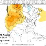
Analogs Agreeable to Very Warm Northwest U.S. in June, Temperate to Cool East
04/16/2026, 10:42 am EDT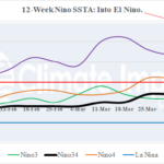
All Nino SSTA Regions Reach El Nino Threshold
04/21/2026, 11:05 am EDT
![]()
Climate Impact Company Sunday Global Weather/Climate Report
Issued: Sunday April 19, 2026
Highlight: Week starts cold in Midwest U.S. followed by warm-up although Canadian Prairies/Northwest Great Plains turn snowy. Europe drought concerns.
This week: Australia/South America Winter (MAY-SEP) Outlook
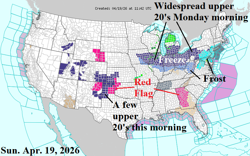
Fig. 1: NOAA/NWS weather watch, warning, and advisory areas. Dark blue represents a Freeze Warning.
Discussion: A Freeze Warning is in effect for the southwest Great Plains this morning (Fig. 1). Generally, the cold underachieved with a few upper 20’s with most areas in the 30’s. A Freeze Warning is in effect tonight for the Midwest/Ohio Valley. Upper 20’s are (more) widespread with this event but over half of the warning area may stay above 32F. Long duration (6+ hours) and middle 20’s are not expected. There may be some lingering cold Tuesday morning in the far eastern Corn Belt. A major warm-up for mid-to-late week follows for the Great Plains/Midwest States.
However, more winter weather is on the way for the Northwest Great Plains and Canadian Prairies Spring Wheat areas. Beginning Thursday and lasting early next week, a snowy/windy pattern emerges (Fig. 2). Morning low temperatures are pushed into the 20’s for several mornings across the Northwest Great Plains (Fig. 3) and 10’s/20’s for the Canadian Prairies (Fig. 4). The big chill shifts east in the 8-14/11-15-day period although <32F risk stays north of the U.S. Corn Belt.
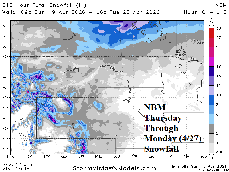
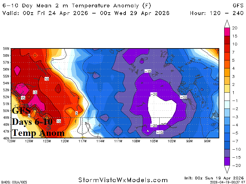
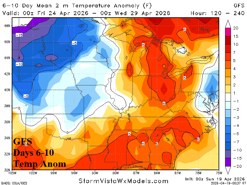
Fig. 2-4: NBM snowfall forecast for THU-MON (next week) and the GFS cold anomalies across the snowbound area centered on the 6-10-day period.
In the U.S., soil moisture deletion remains a large problem for the southeast quadrant of the nation (Fig. 5) where April soil moisture change is much drier (Fig. 6). The West-central U.S. remains historically dry including Western Nebraska. Historically wet conditions are centered on the Great Lakes region, a condition that is worsening. An overview of 14-day precipitation expectations across the Great Plains features a transition between moderate wet conditions for the East-central U.S. in the (NBM) 1-7-day outlook (Fig. 7) shifting farther south and slightly more intense in the (AIFS ENS) 8-14-day period (Fig. 8). Note the western Great Plains are dry this week with ½-1 inch of rain indicated in the 8-14-day forecast.
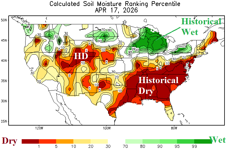
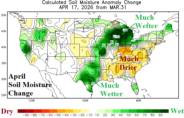
Fig. 5-6: NBM snowfall forecast for THU-MON (next week) and the GFS cold anomalies across the snowbound area centered on the 6-10-day period.
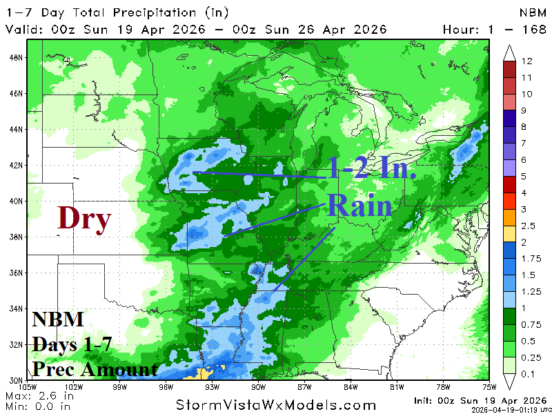
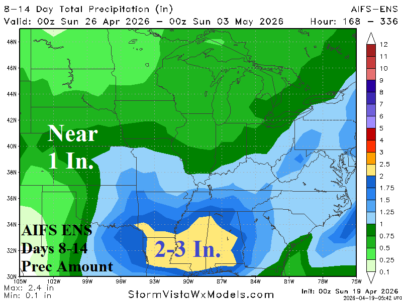
Fig. 7-8: NBM 1-7-day and the AIFS ENS 8-14-day precipitation amount forecast across the U.S. AG Belt.
Last week’s percent normal rainfall across Europe was mostly arid (Fig. 9). The wet weather pattern in the Black Sea region shifted eastward. Consequently, expanding dry soil conditions in Europe are notable (Fig. 10). Combining equally the GFS and ECM, the 10-day rainfall outlook emphasizes dryness across Western Europe and Caspian Sea eastward while wet weather returns to The Black Sea region (Fig. 11). In the 11-15-day period, Western Europe stays dry with a wet bias across West/Southwest Russia to the Black Sea region (Fig. 12).
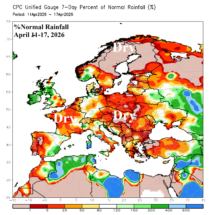
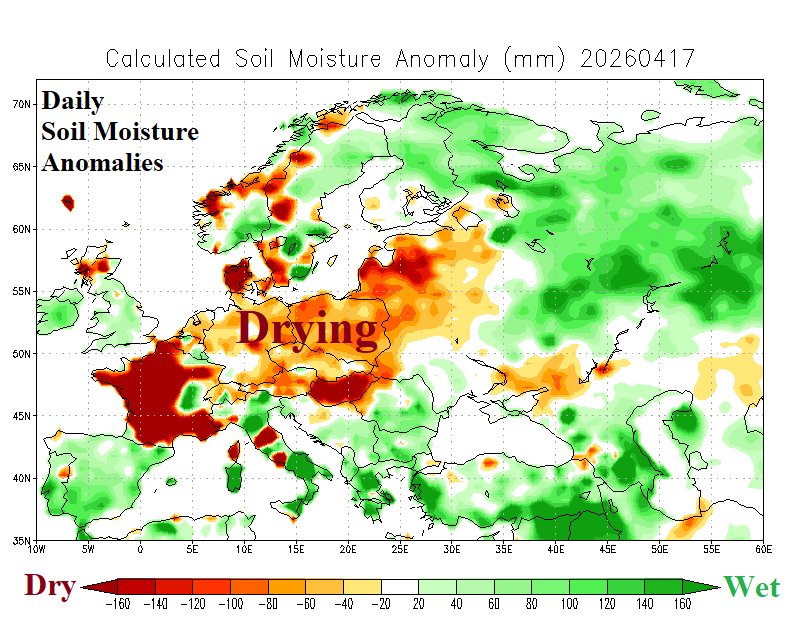
Fig. 9-10: The percent normal precipitation for April 11-17, 2026, and daily soil moisture anomaly analysis across Europe into Western Russia.
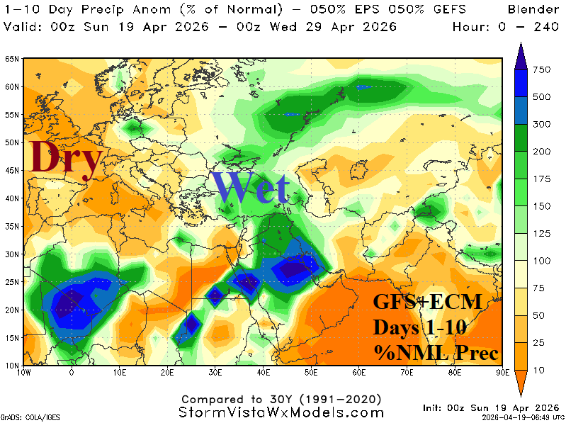
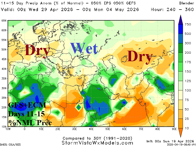
Fig. 11-12: The GFS+ECM 10-day and 11-15-day percent of normal precipitation forecast across Europe and Western Russia.