U.S. April 2026 Climate Report
05/08/2026, 1:45 pm EDTClimate Research: Super El Nino increasingly likely. Where are the first (climate) targets?
05/12/2026, 1:49 pm EDT
Climate Impact Company Tropical Feature
Issued: Tuesday May 12, 2026
Highlight: North America SSTA Report; Western subtropics and deep tropics significant warming ahead.
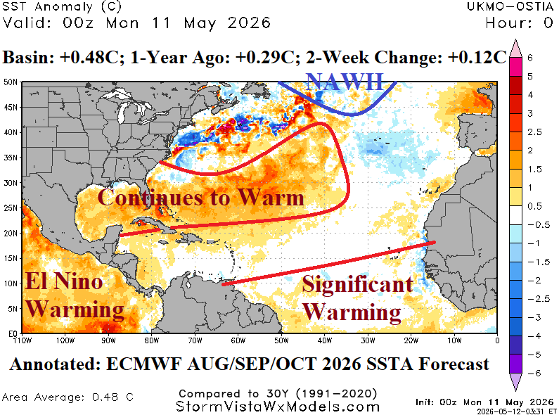
Fig. 1: The North Atlantic basin daily SSTA analysis and annotated regions of major warming or cooling as forecast by ECMWF for AUG/SEP//OCT 2026.
Discussion: As mid-May approaches, just a few weeks before onset of tropical cyclone season, the North Atlantic basin is moderately warm (+0.48C) which is about 0.2C warmer than one year ago and generally cooler than basin SSTA for this time of year during the past decade (Fig. 1). The warm regions are the Gulf of Mexico (basin average +0.88C) and eastward across the Bahamas to southeast of Bermuda. Other areas are cooler than normal, especially off the Mid-Atlantic Coast and southwest of Portugal. The North Atlantic warm hole (NAHW) south of Greenland is developing.
Upper ocean heat analysis reveals the deep tropics of the North Atlantic basin are slightly warmer that the 2013-25 (available) climatology and moderately warmer than normal in the Caribbean Sea and Gulf of Mexico.
The ECMWF SSTA forecast for the peak of tropical cyclone season (AUG/SEP/OCT) indicates the Gulf of Mexico and western subtropical North Atlantic basin will continue to warm, compared to normal. Additionally, and this is a forecast change, the deep tropics are (also) expected to warm significantly during late summer. The NAWH pattern south of Greenland continues to cool, characteristic of the slowdown in the Atlantic Meridional Oceanic Conveyor (AMOC) which began last decade.
El Nino is forecast for the tropical cyclone season. However, several to as much as 6 hurricanes are still likely this season. Tropical systems moving across the warm SSTA of the Gulf of Mexico and waters east of Florida will be capable of over-achieving strengthening and intensity during AUG/SEP/OCT.