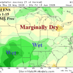
Mid-south U.S. Trends Wetter; Looks Wet for June
05/29/2025, 3:54 am EDT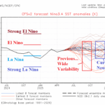
Wide Variation in ENSO Forecasts for Later 2025 Continue
06/02/2025, 9:26 am EDTClimate Impact Company U.S. Sunday Report
Issued: Sunday, June 1, 2025
Highlight: Transitory heat risk Upper Midwest to Northeast this week; Central U.S. severe weather and flooding rains.
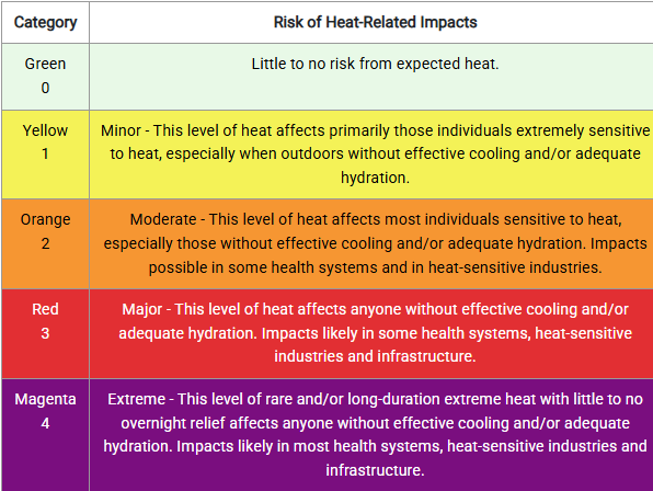

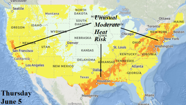
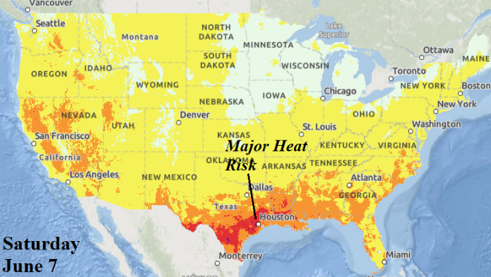
Fig. 1-4: NOAA risk of heat-related impacts KEY and 3 days (of the next week) with the most important heat risk.
Discussion: The NOAA risk of heat-related impacts forecast returns today (Fig. 1). Climate Impact Company will use the most important potential hot weather days in daily reports. Today, highlighted are 3 days of important heat. The first is tomorrow when unusual moderate heat risk affects the Upper Midwest (Fig. 2). The “unusual” moderate heat risk shifts across the Ohio Valley midweek and through the Northeast Corridor on Thursday (Fig. 3). Low 90’s can occur in this zone. The highest heat risk (relative to normal) this week is on Saturday and targets the San Antonio to Houston area (Fig. 4).
The NOAA/WPC 7-day quantitative precipitation forecast identifies areas of heavy rain (and attendant severe weather) most notably across the Great Plains early this week (Fig. 5). Nebraska is targeted for heavy rain/flood risk tomorrow and the southeast Great Plains on Tuesday. The largest severe weather outbreak is Tuesday from Texas to Iowa. The cold front causal to the severe storms and heavy rain stalls in the southern Great Plains to Ohio Valley WED/THU (Fig. 6). The frontal heavy rain continues in the southeast Great Plains late week (Fig. 7). Oklahoma is targeted for potentially significant flooding by mid-to-late week.
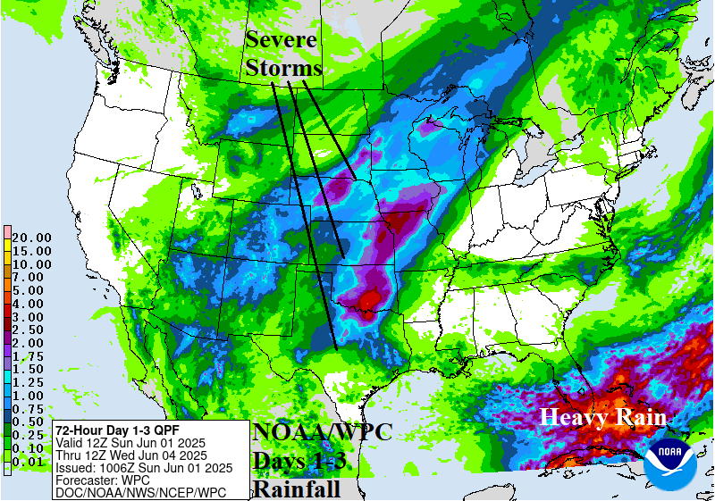
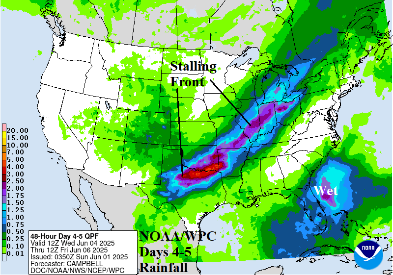

Fig. 5-7: NOAA/WPC rainfall forecasts during the next 7 days.
The U.S. medium range forecast identifies the influence of a widening wet soil moisture regime centered on the Mid-south States on the thermal pattern. In the wet soil moisture region, anomalous heat risk is suppressed while dry areas in the West and Southwest are consistently hot and some of that warm weather extends eastward reaching the Northeast U.S. Corridor (Fig. 8-9).

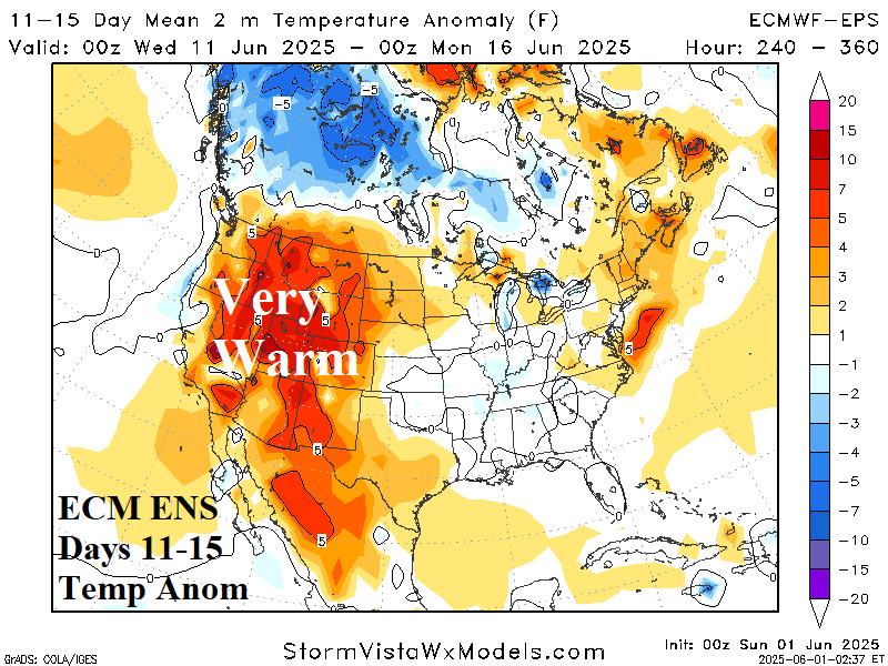
Fig. 8-9: The ECM ENS U.S. medium range temperature anomaly forecast.
In the tropics, monitoring for any tropical development near Florida is warranted for mid-to-late week. GFS indicates the possibility of low pressure forming off the Florida East Coast. Other models including ECM and AI are doubting tropical cyclone development through the next 10 days. GFS continues to indicate a Caribbean to Gulf tropical cyclone risk in 10+ days.