May 8 Busiest Day of Severe Weather Season So Far
05/09/2024, 9:24 am EDTTropical Feature: Suddenly, the Gulf of Mexico is warming rapidly.
05/13/2024, 10:52 am EDT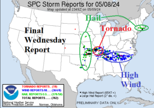
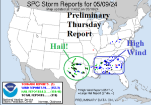
Fig. 1-2: NOAA/SPC preliminary severe weather reports for Thursday and final report for Wednesday. Hail damage reports numbered 538 for the 2 days.
Discussion: The severe weather outbreaks of the past 2 days produced a rare excessive amount of hail damage reports (538) centered on Texas yesterday and the Missouri Valley on Wednesday (Fig. 1-2). Damaging wind was focused on the southeast quadrant of the U.S. while Wednesday’s tornadoes were mostly focused on Southern Illinois and Southeast Missouri.
The next event unfolds this weekend across the southern Great Plains and Texas with 1-3 in. of rain likely by Sunday night (Fig. 3). Early next week the wet weather shifts into the Southeast and intensifies with excessive flooding rains likely from New Orleans to Jacksonville (Fig. 4). The middle of next week features another heavy rain event centered on Louisiana (Fig. 5). 7-day totals reach 10 in. of rain across Louisiana and Mississippi.
The U.S. populated weight CDD forecast is in-between the 10-year and 30-year normal through the remainder of May (Fig. 6).
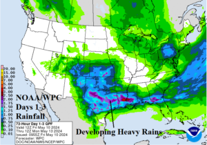
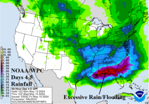
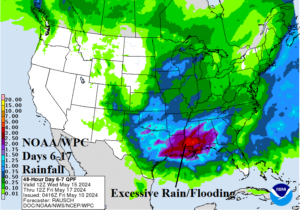
Fig. 3-5: NOAA/WPC rainfall forecast through the next 7 days across the U.S.
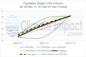
Fig. 6: The U.S. population weight CDD forecast utilizing all models, their consensus, and comparing with 24 hours ago and the 10-year/30-year normal.