Over 1,000 Severe Weather Reports Past 2 Days Most of Which Were Hail Damage
05/10/2024, 8:47 am EDTFirst Major U.S. Heatwave of Season Ahead for Texas
05/14/2024, 1:40 pm EDT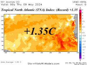
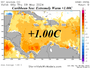
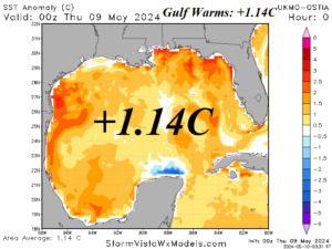
Fig 1-3: Daily SSTA across the main development region for hurricanes across the tropical North Atlantic, Caribbean Sea, and Gulf of Mexico.
Discussion: The main development region for North Atlantic hurricanes is located between the eastern edge of the Caribbean Sea and off the northwest coast of Africa. Conveniently, the tropical North Atlantic (TNA) index is an SSTA for this region. The TNA index remains at record levels with a +1.35C value observed late last week (Fig. 1). The TNA index has not changed much during the past 30 days. The TNA index has observed record warm anomalies since last September. The Caribbean Sea has a robust SSTA of +1.00 (Fig. 2). The trend is about 0.2C warmer during the past 14 days. In the Gulf of Mexico, rapid warming has occurred. The basin average is a robust warm +1.14C (Fig. 3) which is almost 1C warmer than one month ago. The Gulf of Mexico warming is likely attributed to the nearby Mexico heatwave and attendant strong upper-level subtropical ridge.