Can I Use Southern Oscillation Index to Approximate Multivariate ENSO Index?
10/20/2025, 7:28 pm EDT
U.S. Gas Population Weight HDD Forecast for 2025-26 Cold Season
10/23/2025, 8:27 am EDT
Climate Impact Company Tropical Feature
Issued: Tuesday October 21, 2025
Highlight: Concern…Melissa could over-achieve given warm Caribbean Sea, and cause devastating flooding to Hispaniola.

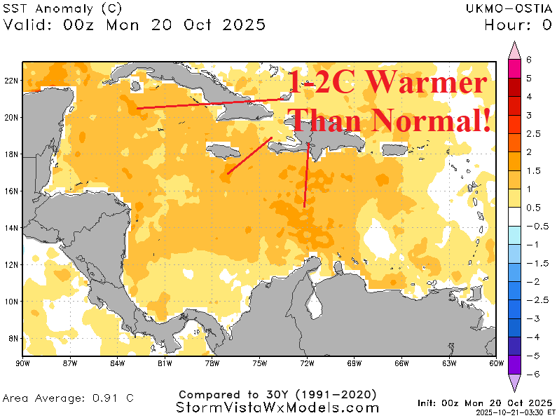
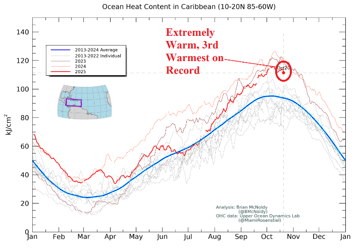
Fig. 1-3: The daily sea surface temperature observations and anomalies across the Caribbean Sea plus recognition of the 3rd warmest upper ocean heat signature on record..
Discussion: At 11AM EDT, NOAA/NHC named Melissa the 13th tropical cyclone of the 2025 season. The preliminary 5-day forecast track by NOAA/NHC indicates a slow west-northwest to north-northwest drift into the Northern Caribbean Sea and slow strengthening to a hurricane later this week. Upper shear is inhibiting development. However, once an organized inner core has formed, given the 86F/30C SST which is 1-2C warmer than normal and 3rd warmest upper ocean heat on record for the Caribbean Sea (Fig. 1-3), there is potential for rapid intensification (RI) as early as Thursday (HWRF) or later this week (HMON) to a strong category-2 hurricane or category-3 major hurricane (Fig. 4-5). HWRF and HMON are farther north and near Haiti later this week. HWRF takes Melissia across the Dominican Republic Friday/Friday night while HMON leaves Melissa just west of Haiti for FRI/SAT. NOAA/NHC recognizes the influence of very warm SST forecasting up to 30 inches of rain near the slow moving west-northwest to northwest track the next few days. The concern is that this type of rainfall could extend northward and given the orography of the Dominican Republic cause an extreme rainfall and flooding event.


Fig. 4-5: HWRF and HMON peak intensity forecast for Melissa later this week.


