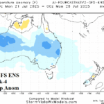
Australia Week 2-4 Outlook: Comparing ECM and AI Temperature Forecasts
07/01/2025, 5:27 am EDT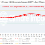
Impressive CDD’s for U.S. and Europe
07/07/2025, 4:58 am EDT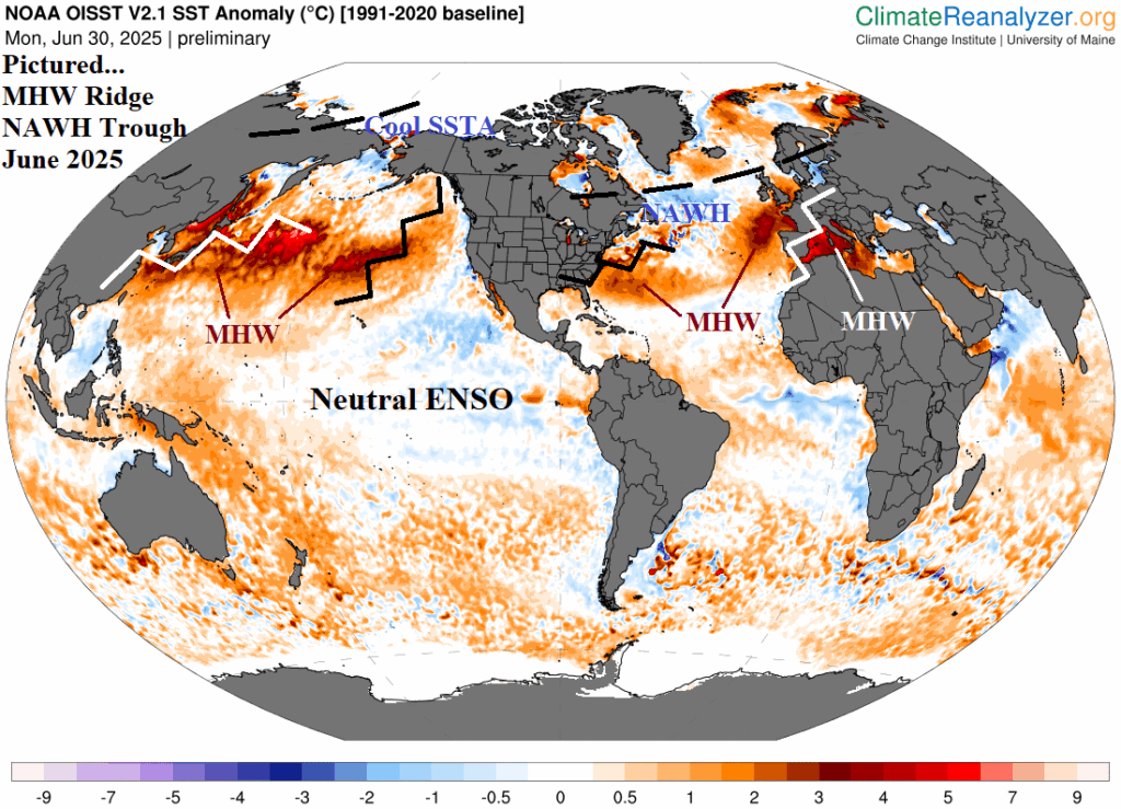
![]()
Climate Impact Company Daily Feature
Issued: Wednesday, July 2, 2025
Review: Marine heatwaves and the June 2025 northern hemisphere climate.
Executive summary: Neutral or weak ENSO events do not imply low-skill climate forecasts. Recognizing the new mid-latitude (mostly warm) SSTA regimes foreshadow climate patterns ahead and recognize the potential for extreme events such as heatwaves, droughts, and flooding rainfall episodes. This phenomenon was vividly present during June 2025 when marine heatwave-driven high pressure ridge areas produced exceptional to record heat in Europe, the East U.S., and East Asia particularly Japan. MHW’s are resilient and usually intensify during summertime implying the JUN-25 hot risk areas are likely to repeat, and may intensify, during the month 1-3 ahead timeframe. MHW’s (and cool areas, such as the North Atlantic warm hole) are excellent climate regime predictors and identify weather extremes within that regime indicators, all (somewhat) independent of ENSO.
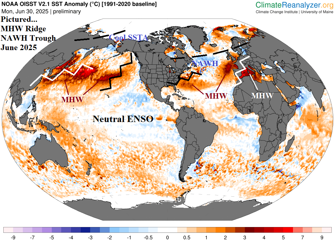
Fig. 1: The daily global SSTA analysis from the University of Maine with annotated June 2025 ridge/trough locations.
Discussion: There is a sentiment out there that climate forecasts are less reliable now due to neutral El Nino southern oscillation (ENSO). Climate Impact Company completely disagrees. Unless a strong ENSO event is present, the mid-latitude ocean sea surface temperature anomaly (SSTA) regimes are taking over as excellent predictors of 1-3-month climate patterns. During the past decade, the mid-latitude oceans have warmed dramatically, usually most evident during mid-to-late summer although in recent years, also influencing winter climate. This observation is true in BOTH hemispheres so while this discussion is regarding North America and Eurasia climate, South America and especially Australia are both profoundly affected. The warming oceans are consolidating into regions of warming referred to as marine heatwaves (MHW). Poleward oceanic warming accelerates high latitude springtime snow and ice-melt which causes fresh water to runoff of land masses and form stratified cool water layers in the upper ocean, most famously south of Greenland and known as the North Atlantic warm hole (NAWH).
These regions of (mostly) warm and cool SSTA are great climate influencers. MHW’s are so large that they are well-correlated with warming the atmosphere aloft to produce amplified high-pressure ridge areas. The phenomenon was on full display during June 2025, most famously in the Mediterranean Sea and west/southwest of Europe where an intense MHW was well-correlated with an upper-level high-pressure ridge bringing historic heat and dryness to Europe. Keep in mind that the SSTA patterns described are notoriously resilient and their attendant climate patterns are difficult to break down. Consequently, the climate pattern intact is likely to persist for 1-3 months.
MHW-inspired upper-level high-pressure ridge areas were also observed across the central North Atlantic extending westward into the East U.S. where an extremely hot JUN-25 climate was observed. The back side of the ridge encouraged moist southerly flow from the Gulf of Mexico which encouraged a wet JUN-25 for the Southwest to the Mid-south U.S. An amplified upper ridge formed across the MHW in the Northeast Pacific. Coastal East Asia and Japan observed a hot JUN-25 due to the MHW-inspired upper ridge extending to their east.
The NAWH south of Greenland is associated with an elongated upper trough extending from Hudson Bay to south of Greenland and into Northwest Eurasia during JUN-25. The upper trough cooled Western Russia and Northeast Canada during early summer and represents a source region of cool air that will try to knock down the hot Europe ridge.
Because MHW’s usually intensify during the summer season, the atmosphere-ocean relationships described are unlikely to change much. The next opportunity for any significant change will be the peak of tropical cyclone season influence on mid-latitude upper air patterns.
In summary, neutral or weak ENSO events do not imply low skill climate forecasts. Recognizing the new mid-latitude (mostly warm) SSTA regimes can not only foreshadow climate patterns ahead but also recognize the potential for extreme events such as heatwaves, droughts, and flooding rainfall episodes.