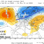
12Z GFS Ends (Temporarily) Europe Heatwave in 6-10 Days
06/30/2025, 1:40 pm EDT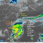
TD 3 Expected to Become a TS; Drift Into South Carolina Tomorrow
07/05/2025, 7:01 am EDT
Climate Impact Company Early AG Market ALERT
Issued: Tuesday July 1, 2025
Highlight: Europe heat and dryness is resilient. Showery U.S. AG Belt.
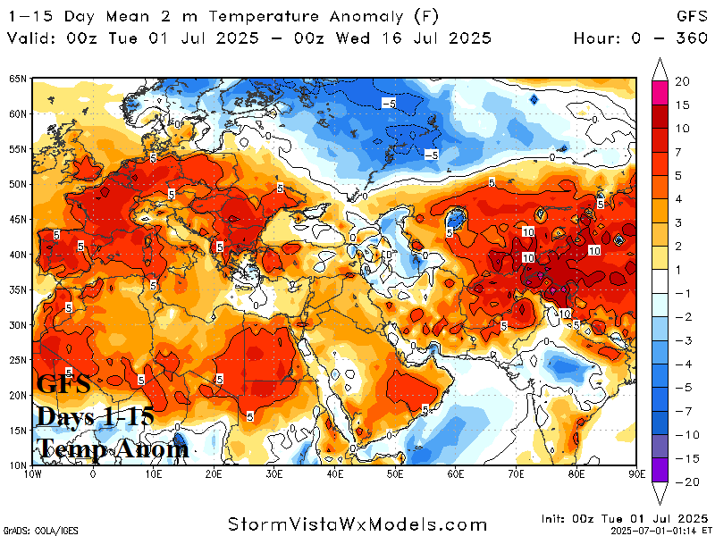

Fig. 1-2: The GFS 15-day temperature anomaly and percent of normal rainfall forecast for Europe/Western Russia.


Fig. 3-4: The JUN-25 percent of normal precipitation observations across the U.S. and 15-day GFS precipitation anomaly outlook.
Discussion: During yesterday’s model runs, some hope of breaking down the Europe heatwave appeared. Midday model runs (GFS) suggested a temporary breakdown during the 6-10-day period followed by regenerating heat in the extended range. The outlooks from overnight are increasingly resilient to breaking down the hot and dry weather pattern. The 15-day GFS temperature anomalies forecast stays hot across West and South Europe (Fig. 1). Thunderstorm activity appears over South-central Europe otherwise dryness is dominant (Fig. 2). Western Russia maintains the cool and wet trough.
The JUN-25 precipitation pattern across the U.S. featured a very dry regime in the West while an active Southwest U.S. Monsoon appeared (Fig. 3). East of the Continental Divide was showery. Preferred is the showery GFS in the 15-day outlook (Fig. 4) as U.S. Crops are off to a good start to the warm season.
Regarding ENSO, the equatorial Pacific upper ocean heat anomalies stay marginally warm in JUN-25. Implied is no risk of La Nina return, although NCEP CFS V2 is boldly forecasting La Nina for late 2025, with marginal support pointed toward El Nino.

Fig. 5: The 12-month upper ocean heat anomalies in the equatorial Pacific.