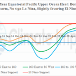
Equatorial Pacific Upper Ocean Heat Remains Marginally Warm in June
07/01/2025, 5:40 am EDT
Tropical Storm Chantal Moves Inland South of Myrtle Beach, SC
07/06/2025, 7:03 am EDT
Climate Impact Company North Atlantic Basin 10-Day Monitor
Issued: Saturday July 5, 2025, 7:00AM EDT
Highlight: Deep tropics stay ALL CLEAR; 3rd subtropics storm of year about to form off South Carolina Coast.

Fig. 1: Satellite view of Tropical Depression Three.
Discussion: Tropical Depression Three is located at 30.8N/78.6W or about 160 miles south-southeast of Charleston, SC. Maximum sustained wind is 35 mph and present movement north-northeast at 2 mph. Central pressure is 1010 MB.
TD3 is located over the Gulf Stream which explains the north-northeast slow drift. The center of TD3 is on the western edge of the attendant thunderstorm activity which identifies TD3 as a disorganized system (Fig. 1). Locally, the shear pattern is light and should allow some intensification over the next 24 hours. The steering pattern should tilt northwestward over the next 24 hours in-between a weak subtropical ridge to the east-northeast of the system and a closed upper-level low in the northeastern Gulf of Mexico.
TD3 is located over the warm 84-85F Gulf Stream. SST cool to 82-83F as this system drifts north and northwest before landfall.
The GFS and ECM operational models each strengthen TD 3 from 101 MB now to 1000 MB at landfall on the central to south-central South Carolina Coast tomorrow morning around 8AM EDT. The lowering low pressure should be enough to upgrade TD3 to a tropical storm (Chantal, the 3rd storm of the season).
NOAA/NHC has adjusted their forecast track farther east at landfall, the upper coast of South Carolina around 6-8AM tomorrow morning as a minimal tropical storm (Fig. 2). The eastward adjustment of their track is based on the short-term slow northeast drift implying a delay in the northwest turn.
Tropical cyclone models are slower to the South Carolina Coast and keep this system weak, barely a tropical storm.
A Tropical Storm Watch is posted for Little River Inlet to Cape Fear. NOAA/WPC indicates several inches of rain today in northeast South Carolina and southeast North Carolina. Heavy rain lingers along the South Carolina/North Carolina border on Sunday. The wet weather will drift northeastward through the Northeast Coastal Communities MON/TUE.
In summary, marginal tropical storm conditions (gusts to 40 mph mostly in heavy thundershowers) for the upper coast of South Carolina/lower coast of North Carolina develop late today and continue into tomorrow. In the wet weather zone, there is some flash flood potential. The storm surge associated with this system is minor, 1-3 feet.
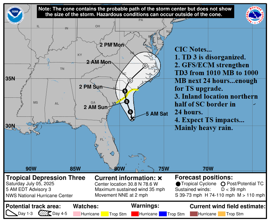
Fig. 2: NOAA/NHC forecast track for T.D. Three.