So Where Is The Cold Air?
02/15/2024, 7:30 pm ESTExtreme (Cold and Warm) Temperature in North America Next Week
02/22/2024, 8:06 am EST
Fig. 1: The global SSTA analysis for Feb. 19, 2024, reveals widespread warmth.
AG Traders and farmer learning point: Australia Bureau of Meteorology issued a statement earlier today that El Nino continues to weaken and that 4 of 7 global models dissipate El Nino by April while the other 3 indicate May. The Bureau also stated that about 50% of all El Nino events since 1900 are followed by neutral ENSO and 40-50% by La Nina. The Bureau emphasized, and Climate Impact Company fully agrees, that the warming of the oceans during the past 50 years could cause interruptions in our historical understanding of ENSO events including making forecasts. During the past year (APR-23 to JAN-24) the global oceans is the warmest on record. The ENSO forecast for the second half of 2024 is developing La Nina but forecast confidence is low due to influence of the record warm global SSTA regime. Stay tuned on ENSO forecasts and climate implications!
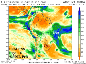
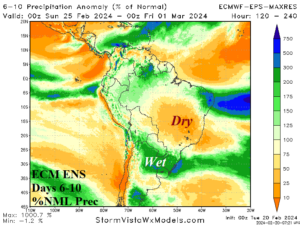
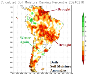
Fig. 2-4: ECMWF MAXRES 1-5-day and 6-10-day percent of normal rainfall forecast across South America plus the daily soil moisture anomaly analysis.
South America discussion: The 10-day outlook has not changed according to ECMWF MAXRES. Emphasized is heavy rain across Eastern Brazil this week with dryness projected for Paraguay and Northeast Argentina (Fig. 2). The weather pattern is unusually changeable for February. During the 6-10-day period, the model shifts wet weather to Paraguay/Northeast Argentina while Brazil turns drier (Fig. 3). Daily soil moisture anomaly analysis reveals continued drought across Southwest to East-central and Northwest Brazil while recent rains have eased Argentina regenerating drought concern (Fig. 4).
Australia discussion: Over-achieving rains continue across North and East Australia. Last week, extreme rainfall was observed on the North Coast with widespread moderate rains on the East Coast (Fig. 5). Western Australia observed no rain. The AI FORECASTNET V2 (model) projects searing heat across the dry zone of the western half of Australia through the next 15 days (Fig. 6).
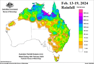
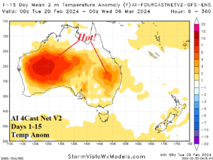
Fig. 5-6: Australia 7-day observed rainfall and the AI FORECASTNET V2 15-day temperature anomaly outlook.