ENSO Predictability Comment
02/20/2024, 5:15 am ESTEast-central U.S. Soils Trending Drier
02/25/2024, 3:26 pm EST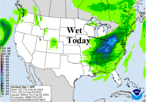
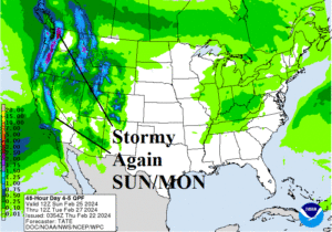
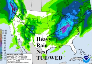
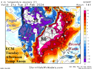
Fig. 1-4: NOAA/WPC 24-hour precipitation forecast for today, SUN/MON, and TUE/WED of next week plus ECM temperature anomaly forecast for next Tuesday afternoon.
Discussion: An inch (or more) of rain is forecast across the eastern Ohio Valley today where a slight risk of flooding exists (Fig. 1). The wet weather is focused along and ahead of a cold front which causes warmer southerly wind into the East today. The wet weather moves off the East Coast tomorrow. Storminess regenerates on the West Coast late weekend mainly in coastal Washington/Oregon (Fig. 2). Precipitation is mostly snow TUE/WED of next week extending across the Central Continental Divide (Fig. 3). At that time, heavy rains regenerate in the Ohio Valley plus the Coastal Northwest. The pattern is fast-moving and produces dramatic thermal contrast from one air mass to the next. An example of the extremes is indicated by ECMWF for next Tuesday afternoon when arctic air surges into Southwest Canada featuring temperatures of -20F to -30F while ahead of the arctic front record warm low 80’s extend to Kansas (Fig. 4).
The U.S. gas population weight HDD forecast yields continued LOW DEMAND heating for late winter although embedded within the mild pattern are brief cold periods especially Northeast (Fig. 5).

Fig. 5: The U.S. gas population weight HDD forecast utilizing all models, their consensus, and comparing with 24 hours ago and the 10-year/30-year normal.